more stats
7.0 miles
Distance
62 ft
Climb
-1,868 ft
Descent
01:27:59
Avg time
-1,806 ft
Altitude change
3,163 ft
Altitude min
4,969 ft
Altitude max
4,969 ft
Altitude start
3,163 ft
Altitude end
-4.9%
Grade
-100.1%
Grade max
11%
Grade min
5,089 ft
Distance climb
6 miles
Distance down
574 ft
Distance flat
01:27:59
Avg time

Laurel Mountain Details

  • Activities
    • Mountain Bike
    • Hike
    • Trail Running
  • Riding Area
    North Mills River
    Mills River, North Carolina
  • Difficulty Rating
  • Local Popularity
    40 in Mountain Biking [+]
    • 55 in Trail Running
    • 40 in Hiking
  • Global Ranking
    #103848 in Mountain Biking [+]
    • #71957 in Trail Running
    • #121996 in Hiking
  • Hiking SAC Scale
    T2 Mountain Hiking
  • Trail Type
    Singletrack
  • Bike Type
    AM, XC
  • Direction
    Both Directions
    Popular Direction Shown
  • Climb Difficulty
    Black Diamond
  • Physical Rating
    Hard
  • Season
    Year Round
  • Dogs Allowed
    Yes
  • eBike Allowed
  • Ride in Rain
    Yes
  • Land Owner
    U.S. Forest Service

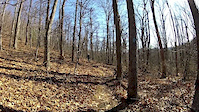
Singletrack trail that follows a steady, grinding grade until hitting Sassafras Gap. At this point, it is mostly hike a bike until shortly before it intersects Pilot Rock

Access Info

3 usual parking spots: Mills River Recreation Area ($3 fee)- climb a long, step gravel road to the crest of the ridge. Trail is 100 yards past crest on right. 2nd aceess point - Park at the crest on the gravel road directly across from the trail. 3rd option - Pullovers at the base of Pilot Cove or Pilot Rock trail

Trail Supporters

  • USFS
    Land Manager

Recent Activity on Trail

Past Week
  • 0 rides
  •  
6 Months
  • 5 rides
  • 37 miles avg distance
All
  • 75 rides
  • Last: Jun 5, 2026
c1c2c3c4
January
February
March
April
May
June
July
August
September
October
November
December
update trails status or condition

Laurel Mountain Trail Reports

statusdatedescription
Sep 19, 2025 @ 12:40am (America/New_York)
Sep 18, 2025
Fallen trees have been cleared and the thick sections of briars and nettles have been trimmed back. Trail is running about as good as it gets. Not...
Aug 1, 2025 @ 9:35pm
Aug 1, 2025
trees down
Jul 5, 2025 @ 5:24pm
Jul 5, 2025
large trees blocking the trail .25 mi from the bottom.
May 1, 2025 @ 8:52am
May 1, 2025
Jan 4, 2025 @ 2:22pm
Jan 4, 2025
Tree down towards the bottom. Rest of it is somewhat icy but in great shape overall.
more »
Status:
on Sep 19, 2025
Ideal
Avg: 3.65 (18 votes)
Your vote: 0

view (738)
close
3D
Trail Conditions
  • Unknown
  • Snow Groomed
  • Snow Packed
  • Snow Covered
  • Snow Cover Partial
  • Freeze/thaw Cycle
  • Icy
  • Prevalent Mud
  • Wet
  • Variable
  • Ideal
  • Dry
  • Very Dry
Trail Flow (Ridden Direction)
Trailforks scans users ridelogs to determine the most popular direction each trail is ridden. A good flowing trail network will have most trails flowing in a single direction according to their intension.
The colour categories are based on what percentage of riders are riding a trail in its intended direction.
  • > 96%
  • > 90%
  • > 80%
  • > 70%
  • > 50%
  • < 50%
  • bi-directional trail
  • no data
Trail Last Ridden
Trailforks scans ridelogs to determine the last time a trail was ridden.
  • < 2 days
  • < 1 week
  • < 2 weeks
  • < 1 month
  • < 6 months
  • > 6 months
Trail Ridden Direction
The intended direction a trail should be ridden.
  • Downhill Only
  • Downhill Primary
  • Both Directions
  • Uphill Primary
  • Uphill Only
  • One Direction
Contribute Details
Colors indicate trail is missing specified detail.
  • Description
  • Photos
  • Description & Photos
  • Videos
Trail Popularity ?
Trailforks scans ridelogs to determine which trails are ridden the most in the last 9 months. Trails are compared with nearby trails in the same city region with a possible 25 colour shades. Think of this as a heatmap, more rides = more kinetic energy = warmer colors.
  • most popular
  • popular
  • less popular
  • not popular
ATV/ORV/OHV Filter
Max Vehicle Width
inches
US Cell Coverage
Legend
cell carrier legend

Radar Time
Activity Recordings
Trailforks uses anonymized public activity data. ?
Activity Recordings
Trailforks uses anonymized public activity data. ?
Personal Heatmap
Activity Types
all / none
Options
2
Date range month
Winter Trails
Warning A routing network for winter maps does not exist. Selecting trails using the winter trails layer has been disabled.
Missing Trails
Most Popular
Least Popular
Trails are colored based on popularity. The more popular a trail is, the more red. Less popular trails trend towards green.
Jump Magnitude Heatmap
Heatmap of where riders jump on trails. Zoom in to see individual jumps, click circles to view jump details.
BC Backroad Status

Service Road Atlas is a free to use, community-driven service for viewing and creating reports on the numerous back-country service roads around B.C. and Alberta.

map legend
Slope Aspect
Direction the slope faces
Flat N NE E SE S SW W NW
Trails Deemphasized
Trails are shown in grey.
disable
Only show trails with no bike usage.
Enable
Suggested Layers
Based on selected activity type

    Save the current map location and zoom level as your default home location whenever this page is loaded.

    Save
        Directions to laurel-mountain trailhead (35.411300, -82.747390)

        Photos

        41 more »
        172 |
        Oct 28, 2022 @ 10:33am
        Oct 28, 2022
        160 |
        Oct 28, 2022 @ 10:29am
        Oct 28, 2022
        184 |
        Oct 28, 2022 @ 10:29am
        Oct 28, 2022
        173 |
        Oct 28, 2022 @ 10:29am
        Oct 28, 2022

        Videos

        1 more »
        Slate Rock Creek
        4:47 | 770 | Dec 21, 2011 , Mills River

        Routes with this trail

        5.0 13 miles 1,921 ft 2 Loop
        This is one of our favorite routes for Laurel Mountain and Pilot Rock that are featured in Freehub...
        3.0 42 miles 6,477 ft 16 Loop
        Pisgah Epic covering some of the best of the area. This route starts at the bottom, climbs up to the Blue...
        143 miles 22,745 ft 29 Loop
        Tour de Brevard - The Showstopper This extremely difficult course throughout the entirety of the...

        Trail Events

        9 Reviews & Comments


        We hope you've been enjoying Trailforks!

        Create a FREE account to view trail comments and much more.

        • By blowmyfuseTF Pro & contributors
        • #35523 - 8,499 views

        Frequently Asked Questions About Laurel Mountain

        Where is Laurel Mountain located?
        Laurel Mountain is located in North Mills River, Mills River, North Carolina, United States. It is part of the North Mills River trail network. The trailhead is located at coordinates 35.4113, -82.74739.
        How hard is Laurel Mountain?
        Laurel Mountain is rated as Black Diamond difficulty. The physical rating is Hard. The average grade is 4.9%. The climb difficulty is rated Black Diamond.
        What is the elevation gain for Laurel Mountain?
        Laurel Mountain has 62 ft of elevation gain. The trail has 1,868 ft of elevation descent. The elevation ranges from 3,163 ft to 4,969 ft.
        Is Laurel Mountain a point to point trail?
        Laurel Mountain is not a point to point trail. The direction is Both Directions. The trail type is singletrack.

        Hit the Trail

        Open in App

        Get this trail on your phone instantly.
        open trail in app

        Download Trail

        Save to wishlist, Garmin & download.
        save the trail

        Find Related Routes

        Find routes and users activities that include this trail.
        find routes for this trail

        You must enter a description before submitting.