more stats
1,837 ft
Distance
6 ft
Climb
-266 ft
Descent
00:03:55
Avg time
-260 ft
Altitude change
2,152 ft
Altitude min
2,418 ft
Altitude max
2,418 ft
Altitude start
2,159 ft
Altitude end
-14.1%
Grade
-41.5%
Grade max
3.4%
Grade min
217 ft
Distance climb
1,581 ft
Distance down
43 ft
Distance flat
00:03:55
Avg time

Ledges Details

  • Activities
    • Mountain Bike
    • E-Bike
  • Riding Area
    Nelson's North Shore
    Nelson, British Columbia
  • Difficulty Rating
  • Voted Difficulty
    Double Black Diamond (2 votes)
  • Local Popularity
    90 in Mountain Biking [+]
    • 75 in E-Biking
  • Global Ranking
    #40053 in Mountain Biking [+]
    • #50505 in E-Biking
  • Trail Type
    Singletrack
  • Bike Type
    DH, AM
  • Direction
    Downhill Only[+]
    Popular Direction Shown
    • Downhill Only for E-Biking
  • Dogs Allowed
    Yes
  • eBike Allowed
    Yes up to Class 1
  • TTFs on Trail
    Rock Face

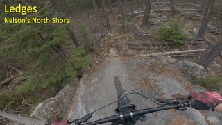
Rarely steep with a wide variety of slabby and rocky terrain, in a good
mixture of descending and all-mountain shredding. At powerlines, turn
left and after 200m of pedaling, you will see two trailheads nearly sideby-
side. First is lower Goose Bumps, next is part two of Ledges.

This trail is unsanctioned.

Recent Activity on Trail

Past Week
  • 1 rides
  • 4 miles average
6 Months
  • 23 rides
  • 6 miles avg distance
All
  • 319 rides
  • Last: Jun 20, 2026
c1c2c3c4
January
February
March
April
May
June
July
August
September
October
November
December
Status:
on Apr 19, 2026
Ideal
Avg: 4.17 (23 votes)
Your vote: 0

view (2,186)
close
3D
Trail Conditions
  • Unknown
  • Snow Groomed
  • Snow Packed
  • Snow Covered
  • Snow Cover Partial
  • Freeze/thaw Cycle
  • Icy
  • Prevalent Mud
  • Wet
  • Variable
  • Ideal
  • Dry
  • Very Dry
Trail Flow (Ridden Direction)
Trailforks scans users ridelogs to determine the most popular direction each trail is ridden. A good flowing trail network will have most trails flowing in a single direction according to their intension.
The colour categories are based on what percentage of riders are riding a trail in its intended direction.
  • > 96%
  • > 90%
  • > 80%
  • > 70%
  • > 50%
  • < 50%
  • bi-directional trail
  • no data
Trail Last Ridden
Trailforks scans ridelogs to determine the last time a trail was ridden.
  • < 2 days
  • < 1 week
  • < 2 weeks
  • < 1 month
  • < 6 months
  • > 6 months
Trail Ridden Direction
The intended direction a trail should be ridden.
  • Downhill Only
  • Downhill Primary
  • Both Directions
  • Uphill Primary
  • Uphill Only
  • One Direction
Contribute Details
Colors indicate trail is missing specified detail.
  • Description
  • Photos
  • Description & Photos
  • Videos
Trail Popularity ?
Trailforks scans ridelogs to determine which trails are ridden the most in the last 9 months. Trails are compared with nearby trails in the same city region with a possible 25 colour shades. Think of this as a heatmap, more rides = more kinetic energy = warmer colors.
  • most popular
  • popular
  • less popular
  • not popular
ATV/ORV/OHV Filter
Max Vehicle Width
inches
US Cell Coverage
Legend
cell carrier legend

Radar Time
Activity Recordings
Trailforks uses anonymized public activity data. ?
Activity Recordings
Trailforks uses anonymized public activity data. ?
Personal Heatmap
Activity Types
all / none
Options
2
Date range month
Winter Trails
Warning A routing network for winter maps does not exist. Selecting trails using the winter trails layer has been disabled.
Missing Trails
Most Popular
Least Popular
Trails are colored based on popularity. The more popular a trail is, the more red. Less popular trails trend towards green.
Jump Magnitude Heatmap
Heatmap of where riders jump on trails. Zoom in to see individual jumps, click circles to view jump details.
BC Backroad Status

Service Road Atlas is a free to use, community-driven service for viewing and creating reports on the numerous back-country service roads around B.C. and Alberta.

map legend
Slope Aspect
Direction the slope faces
Flat N NE E SE S SW W NW
Trails Deemphasized
Trails are shown in grey.
disable
Only show trails with no bike usage.
Enable
Suggested Layers
Based on selected activity type

    Save the current map location and zoom level as your default home location whenever this page is loaded.

    Save
        Directions to ledges trailhead (49.616260, -117.129030)

        Photos

        38 more »
        489 |
        Nov 30, 2014 @ 5:51pm
        Nov 30, 2014
        73 |
        Sep 22, 2025 @ 8:47pm
        Sep 22, 2025
        72 |
        Sep 22, 2025 @ 8:47pm
        Sep 22, 2025
        90 |
        Jul 22, 2024 @ 12:17pm
        Jul 22, 2024

        Videos

        3 more »
        Ledges (Nelson's North Shore)
        3:11 | 545 | Apr 22, 2022 , Nelson
        youtuber Mountain Biking: Ledges, Nelson, BC
        4:28 | 995 | Jan 27, 2020 , Nelson
        Ledges, Nelson BC
        3:31 | 1409 | May 21, 2011 , Nelson

        Trail Products

        4 Reviews & Comments


        We hope you've been enjoying Trailforks!

        Create a FREE account to view trail comments and much more.

        • #2286 - 6,161 views

        Frequently Asked Questions About Ledges

        Where is Ledges located?
        Ledges is located in Nelson's North Shore, Nelson, British Columbia, Canada. It is part of the Nelson's North Shore trail network. The trailhead is located at coordinates 49.61626, -117.12903.
        How hard is Ledges?
        Ledges is rated as Black Diamond difficulty. The average grade is 14.1%.
        What is the elevation gain for Ledges?
        Ledges has 6 ft of elevation gain. The trail has 266 ft of elevation descent. The elevation ranges from 2,152 ft to 2,418 ft.
        Is Ledges a point to point trail?
        Yes, Ledges is a point to point trail. The direction is Downhill Only. The trail type is singletrack.

        Hit the Trail

        Open in App

        Get this trail on your phone instantly.
        open trail in app

        Download Trail

        Save to wishlist, Garmin & download.
        save the trail

        Find Related Routes

        Find routes and users activities that include this trail.
        find routes for this trail

        You must enter a description before submitting.