more stats
1.4 miles
Distance
3 ft
Climb
-691 ft
Descent
00:05:33
Avg time
-689 ft
Altitude change
9,165 ft
Altitude min
9,854 ft
Altitude max
9,854 ft
Altitude start
9,167 ft
Altitude end
-9.5%
Grade
-47.2%
Grade max
4.2%
Grade min
190 ft
Distance climb
1 mile
Distance down
266 ft
Distance flat
00:05:33
Avg time

Lemonade Details

  • Activities
    • Mountain Bike
    • E-Bike
  • Riding Area
    Angel Fire Bike Park
    Angel Fire, New Mexico
  • Difficulty Rating
  • Local Popularity
    25 in Mountain Biking
  • Global Ranking
    #109791 in Mountain Biking
  • Trail Type
    Singletrack
  • Bike Type
    AM
  • Direction
    Downhill Only
    Popular Direction Shown
  • eBike Allowed
  • TTFs on Trail
    Berm, Bridge, Jump
  • Land Owner

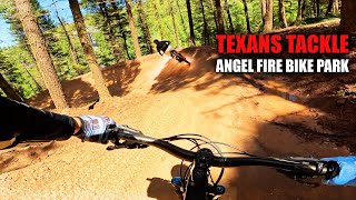
Really fun and flowing trail with big berms. Not as difficult as Angel's Plunge.

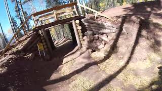
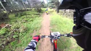
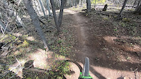
This trail starts with a drop right under the chairlift and quickly enters a short section of single track through the trees. Then you are into the new loam section. True loam, this area has no particular lines, they are still being bedded in and has a good off-camber and a nice steep into a hard turn. Then you are on the motorway. Leaving your fingers off the brakes will let you easily see speeds of over 30 mph here. You might want to scrub some of that speed for the optional jumps on the left. After a brief section of big berms and little jumps (you've got to really work the berms to make the jumps) you are back onto more motorway. As you finish the motorway, you will re-enter the woods and some rocky and rooty single track that, unless it has rained (or is raining) is going to be dusty. Lots of fun twists and turns here. Finally there is a fast section into a big left hand berm that takes you to a nice table top and back out under the chair lift to continue on to Lower Boogie or Pinball

Bike Park

Recent Activity on Trail

Past Week
  • 3 rides
  • 43 miles average
6 Months
  • 11 rides
  • 40 miles avg distance
All
  • 215 rides
  • Last: Jun 17, 2026
c1c2c3c4
January
February
March
April
May
June
July
August
September
October
November
December
update trails status or condition

Lemonade Trail Reports

Status:
on Jun 17, 2026
Ideal
Avg: 4.06 (8 votes)
Your vote: 0

view (2,382)
close
3D
Trail Conditions
  • Unknown
  • Snow Groomed
  • Snow Packed
  • Snow Covered
  • Snow Cover Partial
  • Freeze/thaw Cycle
  • Icy
  • Prevalent Mud
  • Wet
  • Variable
  • Ideal
  • Dry
  • Very Dry
Trail Flow (Ridden Direction)
Trailforks scans users ridelogs to determine the most popular direction each trail is ridden. A good flowing trail network will have most trails flowing in a single direction according to their intension.
The colour categories are based on what percentage of riders are riding a trail in its intended direction.
  • > 96%
  • > 90%
  • > 80%
  • > 70%
  • > 50%
  • < 50%
  • bi-directional trail
  • no data
Trail Last Ridden
Trailforks scans ridelogs to determine the last time a trail was ridden.
  • < 2 days
  • < 1 week
  • < 2 weeks
  • < 1 month
  • < 6 months
  • > 6 months
Trail Ridden Direction
The intended direction a trail should be ridden.
  • Downhill Only
  • Downhill Primary
  • Both Directions
  • Uphill Primary
  • Uphill Only
  • One Direction
Contribute Details
Colors indicate trail is missing specified detail.
  • Description
  • Photos
  • Description & Photos
  • Videos
Trail Popularity ?
Trailforks scans ridelogs to determine which trails are ridden the most in the last 9 months. Trails are compared with nearby trails in the same city region with a possible 25 colour shades. Think of this as a heatmap, more rides = more kinetic energy = warmer colors.
  • most popular
  • popular
  • less popular
  • not popular
ATV/ORV/OHV Filter
Max Vehicle Width
inches
US Cell Coverage
Legend
cell carrier legend

Radar Time
Activity Recordings
Trailforks uses anonymized public activity data. ?
Activity Recordings
Trailforks uses anonymized public activity data. ?
Personal Heatmap
Activity Types
all / none
Options
2
Date range month
Winter Trails
Warning A routing network for winter maps does not exist. Selecting trails using the winter trails layer has been disabled.
Missing Trails
Most Popular
Least Popular
Trails are colored based on popularity. The more popular a trail is, the more red. Less popular trails trend towards green.
Jump Magnitude Heatmap
Heatmap of where riders jump on trails. Zoom in to see individual jumps, click circles to view jump details.
BC Backroad Status

Service Road Atlas is a free to use, community-driven service for viewing and creating reports on the numerous back-country service roads around B.C. and Alberta.

map legend
Slope Aspect
Direction the slope faces
Flat N NE E SE S SW W NW
Trails Deemphasized
Trails are shown in grey.
disable
Only show trails with no bike usage.
Enable
Suggested Layers
Based on selected activity type

    Save the current map location and zoom level as your default home location whenever this page is loaded.

    Save
        Directions to lemonade trailhead (36.377510, -105.248840)

        Photos

        7 more »
        39 |
        Oct 30, 2022 @ 4:12pm
        Oct 30, 2022
        36 |
        Oct 30, 2022 @ 4:12pm
        Oct 30, 2022
        62 |
        Oct 30, 2022 @ 4:11pm
        Oct 30, 2022
        44 |
        Oct 30, 2022 @ 4:11pm
        Oct 30, 2022

        Videos

        4 more »
        Angel Fire Bike Park 2024 | Almost every...
        52:22 | 57 | Jan 6, 2025 , Angel Fire
        Angel Fire Bike Park // Lemonade Flow trail...
        3:35 | 201 | Oct 30, 2022 , Angel Fire
        LEMONADE Trail - Angel Fire Bike Park Gravity...
        3:17 | 452 | Mar 14, 2018 , Angel Fire
        Washout on Lemonade
        0:20 | 96 | Sep 25, 2020 , Angel Fire

        Reviews / Comments

        No reviews yet, be the first to write a review or ask a question.
        Use trail reports to comment on trail conditions.


        We hope you've been enjoying Trailforks!

        Create a FREE account to view trail comments and much more.

        Frequently Asked Questions About Lemonade

        Where is Lemonade located?
        Lemonade is located in Angel Fire Bike Park, Angel Fire, New Mexico, United States. It is part of the Angel Fire Bike Park trail network. The trailhead is located at coordinates 36.37751, -105.24884.
        How hard is Lemonade?
        Lemonade is rated as Blue difficulty. The average grade is 9.5%.
        What is the elevation gain for Lemonade?
        Lemonade has 3 ft of elevation gain. The trail has 691 ft of elevation descent. The elevation ranges from 9,165 ft to 9,854 ft.
        Is Lemonade a point to point trail?
        Yes, Lemonade is a point to point trail. The direction is Downhill Only. The trail type is singletrack.

        Hit the Trail

        Open in App

        Get this trail on your phone instantly.
        open trail in app

        Download Trail

        Save to wishlist, Garmin & download.
        save the trail

        Find Related Routes

        Find routes and users activities that include this trail.
        find routes for this trail

        You must enter a description before submitting.