more stats
5,043 ft
Distance
36 ft
Climb
-589 ft
Descent
00:10:17
Avg time
-552 ft
Altitude change
4,095 ft
Altitude min
4,648 ft
Altitude max
4,648 ft
Altitude start
4,094 ft
Altitude end
-11%
Grade
-43.6%
Grade max
14.6%
Grade min
633 ft
Distance climb
3,999 ft
Distance down
407 ft
Distance flat
00:10:17
Avg time

LESS Details

  • Activities
    • Mountain Bike
    • Hike
    • Trail Running
  • Riding Area
    Westside - Sproatt
    Whistler, British Columbia
  • AKA
    LESS LOTS
  • Difficulty Rating
  • Local Popularity
    65 in Mountain Biking [+]
    • 45 in Trail Running
    • 45 in Hiking
  • Global Ranking
    #45490 in Mountain Biking [+]
    • #91034 in Trail Running
    • #102325 in Hiking
  • Trail Type
    Singletrack
  • Bike Type
    AM, XC
  • Climb Difficulty
    Black Diamond
  • Physical Rating
    Moderate
  • eBike Allowed
  • TTFs on Trail
    Berm, Bridge
  • Year Opened
    2017

DOGS ARE NOT PERMITTED on the Mount Sproatt and Rainbow Mountain Alpine Trail Network to minimize potential conflict with wildlife.
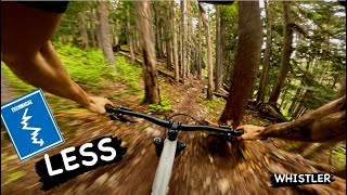
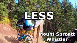
E BIKES ARE NOT PERMITTED on these trails (i.e. anything above Flank: Lord of the Squirrels, Into the Mystic, With a Twist, On the Rocks, Happy Hour, Pot of Gold, LESS & Don't Look Back). The reason for this is to support environmental considerations, user safety and grizzly bear management in the alpine.

Less allows riders to have a less physical decent that starts from just bellow the alpine. The trail construction was just finished mid summer 2018 so its very dry and dusty along the bottom half of the route. If you can avoid riding the trail till the rains return in the fall you will enjoy it more and the trail will be in much better shape for years to come.

Additionally this will allow use early and late season when/if the alpine portion is closed due to snow and/or wet conditions.

Access Info

starts at ~1440m elv on Into the Mystic

Trail Supporters
Local Trail Association

Recent Activity on Trail

Past Week
  • 3 rides
  • 11 miles average
6 Months
  • 4 rides
  • 11 miles avg distance
All
  • 468 rides
  • Last: Jun 3, 2026
c1c2c3c4
January
February
March
April
May
June
July
August
September
October
November
December
update trails status or condition

LESS Trail Reports

statusdatedescription
Jun 3, 2026 @ 7:34pm (America/Vancouver)
2 days
reporter Cleared all deadfall. Still flow killing snow in the first 200m. should be GTG by the weekend (Jun 6) WORCA trail crew
May 21, 2026 @ 1:23pm (America/Vancouver)
May 21, 2026
Give it a couple more weeks for the snow to melt. Still significant minifields of 10-20cm+ snow
May 17, 2026 @ 11:18am (America/Vancouver)
May 17, 2026
Snow covered at the top, lots of pushing the bike. Also lots of fallen trees
Dec 24, 2025 @ 10:07pm (America/Vancouver)
Dec 24, 2025
Sep 12, 2025 @ 11:29am (America/Vancouver)
Sep 12, 2025
more »
Status:
on Jun 3, 2026
Snow Covered
Avg: 4.19 (15 votes)
Your vote: 0

view (2,102)
close
3D
Trail Conditions
  • Unknown
  • Snow Groomed
  • Snow Packed
  • Snow Covered
  • Snow Cover Partial
  • Freeze/thaw Cycle
  • Icy
  • Prevalent Mud
  • Wet
  • Variable
  • Ideal
  • Dry
  • Very Dry
Trail Flow (Ridden Direction)
Trailforks scans users ridelogs to determine the most popular direction each trail is ridden. A good flowing trail network will have most trails flowing in a single direction according to their intension.
The colour categories are based on what percentage of riders are riding a trail in its intended direction.
  • > 96%
  • > 90%
  • > 80%
  • > 70%
  • > 50%
  • < 50%
  • bi-directional trail
  • no data
Trail Last Ridden
Trailforks scans ridelogs to determine the last time a trail was ridden.
  • < 2 days
  • < 1 week
  • < 2 weeks
  • < 1 month
  • < 6 months
  • > 6 months
Trail Ridden Direction
The intended direction a trail should be ridden.
  • Downhill Only
  • Downhill Primary
  • Both Directions
  • Uphill Primary
  • Uphill Only
  • One Direction
Contribute Details
Colors indicate trail is missing specified detail.
  • Description
  • Photos
  • Description & Photos
  • Videos
Trail Popularity ?
Trailforks scans ridelogs to determine which trails are ridden the most in the last 9 months. Trails are compared with nearby trails in the same city region with a possible 25 colour shades. Think of this as a heatmap, more rides = more kinetic energy = warmer colors.
  • most popular
  • popular
  • less popular
  • not popular
ATV/ORV/OHV Filter
Max Vehicle Width
inches
US Cell Coverage
Legend
cell carrier legend

Radar Time
Activity Recordings
Trailforks uses anonymized public activity data. ?
Activity Recordings
Trailforks uses anonymized public activity data. ?
Personal Heatmap
Activity Types
all / none
Options
2
Date range month
Winter Trails
Warning A routing network for winter maps does not exist. Selecting trails using the winter trails layer has been disabled.
Missing Trails
Most Popular
Least Popular
Trails are colored based on popularity. The more popular a trail is, the more red. Less popular trails trend towards green.
Jump Magnitude Heatmap
Heatmap of where riders jump on trails. Zoom in to see individual jumps, click circles to view jump details.
BC Backroad Status

Service Road Atlas is a free to use, community-driven service for viewing and creating reports on the numerous back-country service roads around B.C. and Alberta.

map legend
Slope Aspect
Direction the slope faces
Flat N NE E SE S SW W NW
Trails Deemphasized
Trails are shown in grey.
disable
Only show trails with no bike usage.
Enable
Suggested Layers
Based on selected activity type

    Save the current map location and zoom level as your default home location whenever this page is loaded.

    Save
        Directions to less trailhead (50.106500, -123.051680)

        Photos

        30 more »
        144 |
        Aug 4, 2022 @ 12:20pm
        Aug 4, 2022
        214 |
        Jul 21, 2020 @ 8:23am
        Jul 21, 2020
        203 |
        Jul 17, 2020 @ 5:38pm
        Jul 17, 2020
        316 |
        Jun 26, 2019 @ 9:28am
        Jun 26, 2019

        Videos

        4 more »
        youtuber LESS | Blue Trail | Whistler 2024
        11:35 | 149 | Jul 16, 2024 , Whistler
        WESTSIDE BLUE LOAMERS - LESS, Lord of the...
        28:33 | 63 | Nov 3, 2024 , Whistler
        Whistler’s most epic ride: Into the Mystic!
        40:37 | 187 | Jun 5, 2023 , Whistler
        LESS - Mount Sproatt, Whistler, BC (A fast fun...
        6:53 | 511 | Sep 30, 2021 , Whistler

        Routes with this trail

        11 miles 2,662 ft 10
        Less ambitious ride than LOTS
        13 miles 3,126 ft 10 Loop
        Starting from the Rainbow Park lot, or pedalling in from the Whistler Village via the Valley Trail. Climb...
        1.0 61 miles 17,303 ft 40 Loop
        Just a loop that i made for fun.

        Trail Products

        11 Reviews & Comments


        We hope you've been enjoying Trailforks!

        Create a FREE account to view trail comments and much more.

        • By flipfantasiaTF Pro WORCA & contributors
        • #104742 - 11,927 views

        Frequently Asked Questions About LESS

        Where is LESS located?
        LESS is located in Westside - Sproatt, Whistler, British Columbia, Canada. It is part of the Westside - Sproatt trail network. The trailhead is located at coordinates 50.1065, -123.05168.
        How hard is LESS?
        LESS is rated as Blue difficulty. The physical rating is Moderate. The average grade is 11%. The climb difficulty is rated Black Diamond.
        What is the elevation gain for LESS?
        LESS has 11 m of elevation gain. The trail has 180 m of elevation descent. The elevation ranges from 1,248 m to 1,417 m.
        How long is LESS?
        LESS is 1.5 km long. The trail type is singletrack.

        Hit the Trail

        Open in App

        Get this trail on your phone instantly.
        open trail in app

        Download Trail

        Save to wishlist, Garmin & download.
        save the trail

        Find Related Routes

        Find routes and users activities that include this trail.
        find routes for this trail

        You must enter a description before submitting.