more stats
2,028 ft
Distance
6 ft
Climb
-154 ft
Descent
00:02:02
Avg time
-148 ft
Altitude change
1,169 ft
Altitude min
1,325 ft
Altitude max
1,325 ft
Altitude start
1,178 ft
Altitude end
-7.3%
Grade
-19.9%
Grade max
5.8%
Grade min
305 ft
Distance climb
1,696 ft
Distance down
23 ft
Distance flat
00:02:02
Avg time

LET'ER SEND Details

  • Activities
    • Mountain Bike
    • E-Bike
    • Hike
    • Trail Running
  • Riding Area
  • Difficulty Rating
  • Local Popularity
    35 in Mountain Biking [+]
    • 80 in E-Biking
    • 5 in Trail Running
    • 70 in Hiking
  • Global Ranking
    #31387 in Mountain Biking [+]
    • #304557 in Trail Running
    • #314921 in Hiking
  • Trail Type
    Machine Groomed
  • Bike Type
    DH, AM, DJ
  • Direction
    Downhill Only
  • Trail Visibility
    Always easy to follow
  • Dogs Allowed
    Yes
  • eBike Allowed
    Yes up to Class 1
  • TTFs on Trail
    Berm, Jump, Gap Jump
  • Year Opened
    2020
  • Land Owner
    City of Pendleton

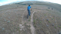
Downhill jump line with sweeping berms, gaps and tables. The jumps range from 10 to 25 feet. There are 2 trail crossing gaps at the end of the line, and there are a lot of critters digging holes in berms and landings so look before you leap.

Local Trail Association
Traditionally Indigenous Territory

Recent Activity on Trail

Past Week
  • 0 rides
  •  
6 Months
  • 1 rides
  • 15 miles avg distance
All
  • 40 rides
  • Last: Apr 27, 2026
c1c2c3c4
January
February
March
April
May
June
July
August
September
October
November
December
update trails status or condition

LET'ER SEND Trail Reports

statusdatedescription
Jul 15, 2025 @ 2:21pm
Jul 15, 2025
Last jump completely covered in weeds and unrideable
Feb 24, 2024 @ 4:52am
Feb 24, 2024
Dirt is a little soft after freeze thaw, but it's definitely ridable
Aug 20, 2022 @ 8:22am
Aug 20, 2022
Mostly clear of weeds on the jump line. Aggressive gap jumps should only be attempted after inspecting the trail for soft sections of dirt or...
Nov 6, 2021 @ 11:20am
Nov 6, 2021
Apr 14, 2021 @ 7:46pm
Apr 14, 2021
more »
Status:
on Jul 15, 2025
Avg: 4.1 (3 votes)
Your vote: 0

view (201)
close
3D
Trail Conditions
  • Unknown
  • Snow Groomed
  • Snow Packed
  • Snow Covered
  • Snow Cover Partial
  • Freeze/thaw Cycle
  • Icy
  • Prevalent Mud
  • Wet
  • Variable
  • Ideal
  • Dry
  • Very Dry
Trail Flow (Ridden Direction)
Trailforks scans users ridelogs to determine the most popular direction each trail is ridden. A good flowing trail network will have most trails flowing in a single direction according to their intension.
The colour categories are based on what percentage of riders are riding a trail in its intended direction.
  • > 96%
  • > 90%
  • > 80%
  • > 70%
  • > 50%
  • < 50%
  • bi-directional trail
  • no data
Trail Last Ridden
Trailforks scans ridelogs to determine the last time a trail was ridden.
  • < 2 days
  • < 1 week
  • < 2 weeks
  • < 1 month
  • < 6 months
  • > 6 months
Trail Ridden Direction
The intended direction a trail should be ridden.
  • Downhill Only
  • Downhill Primary
  • Both Directions
  • Uphill Primary
  • Uphill Only
  • One Direction
Contribute Details
Colors indicate trail is missing specified detail.
  • Description
  • Photos
  • Description & Photos
  • Videos
Trail Popularity ?
Trailforks scans ridelogs to determine which trails are ridden the most in the last 9 months. Trails are compared with nearby trails in the same city region with a possible 25 colour shades. Think of this as a heatmap, more rides = more kinetic energy = warmer colors.
  • most popular
  • popular
  • less popular
  • not popular
ATV/ORV/OHV Filter
Max Vehicle Width
inches
US Cell Coverage
Legend
cell carrier legend

Radar Time
Activity Recordings
Trailforks uses anonymized public activity data. ?
Activity Recordings
Trailforks uses anonymized public activity data. ?
Personal Heatmap
Activity Types
all / none
Options
2
Date range month
Winter Trails
Warning A routing network for winter maps does not exist. Selecting trails using the winter trails layer has been disabled.
Missing Trails
Most Popular
Least Popular
Trails are colored based on popularity. The more popular a trail is, the more red. Less popular trails trend towards green.
Jump Magnitude Heatmap
Heatmap of where riders jump on trails. Zoom in to see individual jumps, click circles to view jump details.
BC Backroad Status

Service Road Atlas is a free to use, community-driven service for viewing and creating reports on the numerous back-country service roads around B.C. and Alberta.

map legend
Slope Aspect
Direction the slope faces
Flat N NE E SE S SW W NW
Trails Deemphasized
Trails are shown in grey.
disable
Only show trails with no bike usage.
Enable
Suggested Layers
Based on selected activity type

    Save the current map location and zoom level as your default home location whenever this page is loaded.

    Save
        Directions to let-er-send trailhead (45.684230, -118.855970)

        Photos

        27 more »
        169 |
        Jan 30, 2022 @ 2:57pm
        Jan 30, 2022
        135 |
        Nov 27, 2021 @ 2:49pm
        Nov 27, 2021
        171 |
        Nov 27, 2021 @ 2:44pm
        Nov 27, 2021
        269 |
        Mar 14, 2021 @ 7:43pm
        Mar 14, 2021

        Videos

        2 more »
        Huge Jumps! Let`er Send & Tower Trail...
        0:57 | 521 | Mar 24, 2022 , Pendleton
        Follow cam!
        0:28 | 348 | Jan 8, 2021 , Pendleton

        Technical Trail Features (TTF)

        Reviews / Comments

        No reviews yet, be the first to write a review or ask a question.
        Use trail reports to comment on trail conditions.


        We hope you've been enjoying Trailforks!

        Create a FREE account to view trail comments and much more.

        • By thailanderTF Pro & contributors
        • #386112 - 1,589 views

        Frequently Asked Questions About LET'ER SEND

        Where is LET'ER SEND located?
        LET'ER SEND is located in Pendleton Adventure Trails Recreational Area, Pendleton, Oregon, United States. It is part of the Pendleton Adventure Trails Recreational Area trail network. The trailhead is located at coordinates 45.68423, -118.85597.
        How hard is LET'ER SEND?
        LET'ER SEND is rated as Double Black Diamond difficulty. The average grade is 7.3%.
        What is the elevation gain for LET'ER SEND?
        LET'ER SEND has 6 ft of elevation gain. The trail has 154 ft of elevation descent. The elevation ranges from 1,169 ft to 1,325 ft.
        Is LET'ER SEND a point to point trail?
        Yes, LET'ER SEND is a point to point trail. The direction is Downhill Only. The trail type is machine groomed.

        Hit the Trail

        Open in App

        Get this trail on your phone instantly.
        open trail in app

        Download Trail

        Save to wishlist, Garmin & download.
        save the trail

        Find Related Routes

        Find routes and users activities that include this trail.
        find routes for this trail

        You must enter a description before submitting.