more stats
2.5 miles
Distance
701 ft
Climb
-46 ft
Descent
00:31:24
Avg time
655 ft
Altitude change
626 ft
Altitude min
1,281 ft
Altitude max
626 ft
Altitude start
1,283 ft
Altitude end
4.9%
Grade
-13%
Grade max
24.6%
Grade min
2 miles
Distance climb
991 ft
Distance down
1,765 ft
Distance flat
00:31:24
Avg time

Level Up Details

  • Activities
    • Mountain Bike
    • Hike
    • Trail Running
  • Riding Area
    Capitol Forest
    Olympia, Washington
  • Difficulty Rating
  • Local Popularity
    100 in Mountain Biking [+]
    • 5 in Trail Running
    • 65 in Hiking
  • Global Ranking
    #34451 in Mountain Biking [+]
    • #128355 in Trail Running
    • #2205 in Hiking
  • Trail Type
    Singletrack
  • Bike Type
    AM, XC
  • Direction
    Both Directions
    Popular Direction Shown
  • Climb Difficulty
    Green
  • Physical Rating
    Easy
  • Trail Visibility
    Always easy to follow
  • Family Friendly
    Yes
  • Dogs Allowed
    Yes
  • eBike Allowed
  • Year Opened
    2018
  • Land Owner
    Washington DNR

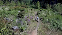
Level Up, a recent addition to trail network in the Fall Creek area. It serves as an alternative to climbing the road on the way to the top of Little Larch Mountain and it is a good trail to practice skills building. It is a joyful beginner trail to ride in both directions.

Local Trail Association
Traditionally Indigenous Territory

Recent Activity on Trail

Past Week
  • 5 rides
  • 12 miles average
6 Months
  • 64 rides
  • 10 miles avg distance
All
  • 506 rides
  • Last: Jun 16, 2026
c1c2c3c4
January
February
March
April
May
June
July
August
September
October
November
December
update trails status or condition

Level Up Trail Reports

statusdatedescription
Jun 11, 2026 @ 12:22pm (America/Vancouver)
Jun 11, 2026
Feb 21, 2026 @ 11:17am (America/Vancouver)
Feb 21, 2026
Couple places before the road crossing, after you exit the tree cover, with patches of snow, but light enough you can ride it. After the road...
Dec 22, 2025 @ 3:27pm (America/Los_Angeles)
Dec 22, 2025
In surprisingly good condition. Lots of small branches down. One large tree down near C-6000. Otherwise in great shape.
Nov 30, 2025 @ 11:37am (America/Vancouver)
Nov 30, 2025
Oct 23, 2025 @ 12:13pm (America/Vancouver)
Oct 23, 2025
Wet but very rideable
more »
Status:
on Jun 11, 2026
Ideal
Avg: 4.2 (9 votes)
Your vote: 0

view (2,531)
close
3D
Trail Conditions
  • Unknown
  • Snow Groomed
  • Snow Packed
  • Snow Covered
  • Snow Cover Partial
  • Freeze/thaw Cycle
  • Icy
  • Prevalent Mud
  • Wet
  • Variable
  • Ideal
  • Dry
  • Very Dry
Trail Flow (Ridden Direction)
Trailforks scans users ridelogs to determine the most popular direction each trail is ridden. A good flowing trail network will have most trails flowing in a single direction according to their intension.
The colour categories are based on what percentage of riders are riding a trail in its intended direction.
  • > 96%
  • > 90%
  • > 80%
  • > 70%
  • > 50%
  • < 50%
  • bi-directional trail
  • no data
Trail Last Ridden
Trailforks scans ridelogs to determine the last time a trail was ridden.
  • < 2 days
  • < 1 week
  • < 2 weeks
  • < 1 month
  • < 6 months
  • > 6 months
Trail Ridden Direction
The intended direction a trail should be ridden.
  • Downhill Only
  • Downhill Primary
  • Both Directions
  • Uphill Primary
  • Uphill Only
  • One Direction
Contribute Details
Colors indicate trail is missing specified detail.
  • Description
  • Photos
  • Description & Photos
  • Videos
Trail Popularity ?
Trailforks scans ridelogs to determine which trails are ridden the most in the last 9 months. Trails are compared with nearby trails in the same city region with a possible 25 colour shades. Think of this as a heatmap, more rides = more kinetic energy = warmer colors.
  • most popular
  • popular
  • less popular
  • not popular
ATV/ORV/OHV Filter
Max Vehicle Width
inches
US Cell Coverage
Legend
cell carrier legend

Radar Time
Activity Recordings
Trailforks uses anonymized public activity data. ?
Activity Recordings
Trailforks uses anonymized public activity data. ?
Personal Heatmap
Activity Types
all / none
Options
2
Date range month
Winter Trails
Warning A routing network for winter maps does not exist. Selecting trails using the winter trails layer has been disabled.
Missing Trails
Most Popular
Least Popular
Trails are colored based on popularity. The more popular a trail is, the more red. Less popular trails trend towards green.
Jump Magnitude Heatmap
Heatmap of where riders jump on trails. Zoom in to see individual jumps, click circles to view jump details.
BC Backroad Status

Service Road Atlas is a free to use, community-driven service for viewing and creating reports on the numerous back-country service roads around B.C. and Alberta.

map legend
Slope Aspect
Direction the slope faces
Flat N NE E SE S SW W NW
Trails Deemphasized
Trails are shown in grey.
disable
Only show trails with no bike usage.
Enable
Suggested Layers
Based on selected activity type

    Save the current map location and zoom level as your default home location whenever this page is loaded.

    Save
        Directions to level-up trailhead (46.940290, -123.125620)

        Photos

        7 more »
        45 |
        Apr 9, 2025 @ 5:48pm
        Apr 9, 2025
        158 |
        Oct 15, 2020 @ 10:24pm
        Oct 15, 2020
        178 |
        Jun 19, 2019 @ 9:14am
        Jun 19, 2019
        152 |
        Jun 19, 2019 @ 9:14am
        Jun 19, 2019

        Videos

        1 more »
        Level Up Trail
        0:24 | 488 | Jul 6, 2019 , Olympia

        Routes with this trail

        4 miles 788 ft 1
        A route that shows total mileage for if you were to pedal the climb trail instead of shuttle.
        15 miles 2,810 ft 2
        The 2nd Annual Summer Classic Team Enduro - presented by Race Cascadia. Stage 1: Little Larch - the first...
        5.0 21 miles 3,228 ft 22 Loop
        This is a ride that ties all the classic short loops out of Fall Creek together.

        8 Reviews & Comments


        We hope you've been enjoying Trailforks!

        Create a FREE account to view trail comments and much more.

        • By AcwuestTF Pro & contributors
        • #148295 - 4,858 views

        Frequently Asked Questions About Level Up

        Where is Level Up located?
        Level Up is located in Capitol Forest, Olympia, Washington, United States. It is part of the Capitol Forest trail network. The trailhead is located at coordinates 46.94029, -123.12562.
        How hard is Level Up?
        Level Up is rated as Green difficulty. The physical rating is Easy. The average grade is 4.9%. The climb difficulty is rated Green.
        What is the elevation gain for Level Up?
        Level Up has 701 ft of elevation gain. The trail has 46 ft of elevation descent. The elevation ranges from 626 ft to 1,281 ft.
        Is Level Up a point to point trail?
        Level Up is not a point to point trail. The direction is Both Directions. The trail type is singletrack.

        Hit the Trail

        Open in App

        Get this trail on your phone instantly.
        open trail in app

        Download Trail

        Save to wishlist, Garmin & download.
        save the trail

        Find Related Routes

        Find routes and users activities that include this trail.
        find routes for this trail

        You must enter a description before submitting.