more stats
2.3 miles
Distance
319 ft
Climb
-281 ft
Descent
00:18:59
Avg time
37 ft
Altitude change
7,766 ft
Altitude min
8,001 ft
Altitude max
7,953 ft
Altitude start
7,989 ft
Altitude end
0.3%
Grade
-20.5%
Grade max
26.3%
Grade min
1 mile
Distance climb
1 mile
Distance down
410 ft
Distance flat
00:18:59
Avg time

Lewis Peak Details

  • Activities
    • Mountain Bike
    • Hike
    • Trail Running
    • Dirtbike/Moto
  • Riding Area
  • Difficulty Rating
  • Local Popularity
    55 in Mountain Biking [+]
    • 80 in Trail Running
    • 85 in Hiking
    • 100 in Dirtbiking
  • Global Ranking
    #109939 in Mountain Biking [+]
    • #76837 in Trail Running
    • #51775 in Hiking
    • #404 in Dirtbiking
  • Hiking SAC Scale
    T2 Mountain Hiking
  • Trail Exposure
    Normal
  • Trail Type
    Singletrack
  • Bike Type
    AM, XC
  • Direction
    Both Directions[+]
    • Both Directions for Trail Running
    • Both Directions for Hiking
    • Both Directions for Dirtbiking
  • Climb Difficulty
    Blue
  • Physical Rating
    Moderate
  • Trail Visibility
    Always easy to follow
  • Dogs Allowed
    Yes
  • eBike Allowed
  • Lighting
    No

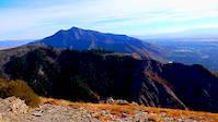
This trail will take you from the main (South) Skyline trail out to Lewis Peak with surrounding views of Ogden. Good tree cover through portions of the trail. There are some very rubbly sections of trail, but overall this trail is not difficult.

Trail Supporters

  • USFS
    Land Manager
Traditionally Indigenous Territory

Recent Activity on Trail

Past Week
  • 1 rides
  • 26 miles average
6 Months
  • 4 rides
  • 26 miles avg distance
All
  • 61 rides
  • Last: Jun 21, 2026
c1c2c3c4
January
February
March
April
May
June
July
August
September
October
November
December
update trails status or condition

Lewis Peak Trail Reports

statusdatedescription
Nov 12, 2025 @ 10:29am (America/Boise)
Nov 12, 2025
80% good. About mile 4.5 to mile 5 there are some wet spots. Would be fine to hit early morning but was a little greasy coming down.
Jun 29, 2025 @ 6:32am
Jun 29, 2025
Sep 20, 2024 @ 10:10am
Sep 20, 2024
Oct 16, 2023 @ 5:54am
Oct 16, 2023
Sep 23, 2023 @ 10:04am
Sep 23, 2023
more »
Status:
on Nov 12, 2025
Freeze/thaw Cycle
Avg: 4.08 (6 votes)
Your vote: 0

view (1,228)
close
3D
Trail Conditions
  • Unknown
  • Snow Groomed
  • Snow Packed
  • Snow Covered
  • Snow Cover Partial
  • Freeze/thaw Cycle
  • Icy
  • Prevalent Mud
  • Wet
  • Variable
  • Ideal
  • Dry
  • Very Dry
Trail Flow (Ridden Direction)
Trailforks scans users ridelogs to determine the most popular direction each trail is ridden. A good flowing trail network will have most trails flowing in a single direction according to their intension.
The colour categories are based on what percentage of riders are riding a trail in its intended direction.
  • > 96%
  • > 90%
  • > 80%
  • > 70%
  • > 50%
  • < 50%
  • bi-directional trail
  • no data
Trail Last Ridden
Trailforks scans ridelogs to determine the last time a trail was ridden.
  • < 2 days
  • < 1 week
  • < 2 weeks
  • < 1 month
  • < 6 months
  • > 6 months
Trail Ridden Direction
The intended direction a trail should be ridden.
  • Downhill Only
  • Downhill Primary
  • Both Directions
  • Uphill Primary
  • Uphill Only
  • One Direction
Contribute Details
Colors indicate trail is missing specified detail.
  • Description
  • Photos
  • Description & Photos
  • Videos
Trail Popularity ?
Trailforks scans ridelogs to determine which trails are ridden the most in the last 9 months. Trails are compared with nearby trails in the same city region with a possible 25 colour shades. Think of this as a heatmap, more rides = more kinetic energy = warmer colors.
  • most popular
  • popular
  • less popular
  • not popular
ATV/ORV/OHV Filter
Max Vehicle Width
inches
US Cell Coverage
Legend
cell carrier legend

Radar Time
Activity Recordings
Trailforks uses anonymized public activity data. ?
Activity Recordings
Trailforks uses anonymized public activity data. ?
Personal Heatmap
Activity Types
all / none
Options
2
Date range month
Winter Trails
Warning A routing network for winter maps does not exist. Selecting trails using the winter trails layer has been disabled.
Missing Trails
Most Popular
Least Popular
Trails are colored based on popularity. The more popular a trail is, the more red. Less popular trails trend towards green.
Jump Magnitude Heatmap
Heatmap of where riders jump on trails. Zoom in to see individual jumps, click circles to view jump details.
BC Backroad Status

Service Road Atlas is a free to use, community-driven service for viewing and creating reports on the numerous back-country service roads around B.C. and Alberta.

map legend
Slope Aspect
Direction the slope faces
Flat N NE E SE S SW W NW
Trails Deemphasized
Trails are shown in grey.
disable
Only show trails with no bike usage.
Enable
Suggested Layers
Based on selected activity type

    Save the current map location and zoom level as your default home location whenever this page is loaded.

    Save
        Directions to lewis-peak trailhead (41.290800, -111.892960)

        Photos

        89 more »
        103 |
        Jan 27, 2021 @ 3:11pm
        Jan 27, 2021
        53 |
        Oct 16, 2020 @ 3:54am
        Oct 16, 2020
        53 |
        Oct 16, 2020 @ 3:55am
        Oct 16, 2020
        44 |
        Oct 16, 2020 @ 3:55am
        Oct 16, 2020

        Videos

        1 more »
        Lewis Peak View
        0:47 | 53 | Oct 16, 2020 , Ogden

        Routes with this trail

        2.5 29 miles 7,402 ft 8
        Starting at the Pineview Reservoir. All major routes. Out and back. The uphill from North Odgen pass is...
        2.0 5 miles 2,200 ft 4 Out & Back
        This route is being created for comprehensiveness. Although the top section is bike friendly and moderate...
        3.0 18 miles 3,703 ft 2

        5 Reviews & Comments


        We hope you've been enjoying Trailforks!

        Create a FREE account to view trail comments and much more.

        • By toddTF Pro Trailforks & contributors
        • #11030 - 3,705 views

        Frequently Asked Questions About Lewis Peak

        Where is Lewis Peak located?
        Lewis Peak is located in South Skyline / Mount Lewis, Ogden, Utah, United States. It is part of the South Skyline / Mount Lewis trail network. The trailhead is located at coordinates 41.2908, -111.89296.
        How hard is Lewis Peak?
        Lewis Peak is rated as Blue difficulty. The physical rating is Moderate. The average grade is 0.3%. The climb difficulty is rated Blue.
        What is the elevation gain for Lewis Peak?
        Lewis Peak has 319 ft of elevation gain. The trail has 281 ft of elevation descent. The elevation ranges from 7,766 ft to 8,001 ft.
        Is Lewis Peak a point to point trail?
        Lewis Peak is not a point to point trail. The direction is Both Directions. The trail type is singletrack.

        Hit the Trail

        Open in App

        Get this trail on your phone instantly.
        open trail in app

        Download Trail

        Save to wishlist, Garmin & download.
        save the trail

        Find Related Routes

        Find routes and users activities that include this trail.
        find routes for this trail

        You must enter a description before submitting.