


Open in App
Get this trail on your phone instantly.

This all-singletrack river trail along the Lewis River in southwest Washington holds its own and is a great all around summer ride. Be sure to take in the views of the lower, middle, and upper falls at the northern end of the trail.
Need to Know
The ride as described below is a true out-and-back singletrack route that traces the the adjacent river. It can easily be set up as a point-to-point shuttle or be done as a loop by utilizing FR 90 to start or end the ride. The trail sees high mountain biker and hiker traffic on weekends throughout the summer. Sections of this trail are very steep or traverse exposed slopes. Made more difficult by the creeks running through, which means some sections are always muddy.
Description
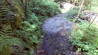
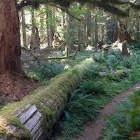
From the small parking area off of FR 9039 on the east side of the river, ride across the bridge and access the south trailhead on the right. From south to north the trail climbs at a mild grade as you ride against the flow of the Lewis River with great views of the water along the way. The tread is varied with fast, smooth segments combined with intermittent short, technical root-packed sections. As you ride through the shady old-growth forest you'll encounter constant short ups and downs as the trail crosses several creeks and streams that feed the river.
Just prior to the 10-mile mark, the trail crosses FR 90 and leads to the Lower Falls Campground. As you continue north take in the views of the lower, middle, and upper falls of the river - any of which make a great spot for a lunch break. Shortly thereafter the trail ends at FR 90 where you can turn around and retrace your route (or to make up some time you can return on FR 90 to the southern trailhead).
As of June 15, 2021 there is 3 months of parking restrictions on FS 90. If you plan on parking anywhere near FS 90, you need to purchase a day parking pass prior to arrival at this website: https://www.recreation.gov/timed-entry/10087203
| c1 | c2 | c3 | c4 |
|---|---|---|---|
January | February | March | April |
May | June | July | August |
September | October | November | December |

Service Road Atlas is a free to use, community-driven service for viewing and creating reports on the numerous back-country service roads around B.C. and Alberta.
Save the current map location and zoom level as your default home location whenever this page is loaded.
SaveWe hope you've been enjoying Trailforks!
Create a FREE account to view trail comments and much more.
You must enter a description before submitting.

