more stats
4,465 ft
Distance
98 ft
Climb
-178 ft
Descent
00:06:59
Avg time
-80 ft
Altitude change
716 ft
Altitude min
802 ft
Altitude max
796 ft
Altitude start
716 ft
Altitude end
-1.79%
Grade
-21.554%
Grade max
17.517%
Grade min
1,552 ft
Distance climb
2,887 ft
Distance down
26 ft
Distance flat
00:06:59
Avg time

Lilac Trail Details

  • Activities
    • Mountain Bike
    • E-Bike
    • Hike
    • Trail Running
  • Riding Area
    Black Mountain
    San Diego, California
  • Difficulty Rating
  • Voted Difficulty
    Blue (3 votes)
  • Local Popularity
    95 in Mountain Biking [+]
    • 95 in E-Biking
    • 100 in Trail Running
    • 95 in Hiking
  • Global Ranking
    #44090 in Mountain Biking [+]
    • #26751 in E-Biking
    • #9433 in Trail Running
    • #41223 in Hiking
  • Trail Type
    Singletrack
  • Direction
    Both Directions
    Popular Direction Shown
  • Dogs Allowed
    Yes
  • eBike Allowed
    Yes up to Class 1

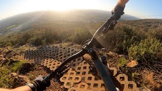
Blue because it has a rock-garden and cornery-bridge that can be challenging for beginners. No shame in walking.

Disclaimer

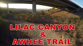
Not suitable for adaptive MTB. Use Carmel Valley Rd to access Awhee.

Local Trail Association
Traditionally Indigenous Territory

Recent Activity on Trail

Past Week
  • 9 rides
  • 9 miles average
6 Months
  • 194 rides
  • 15 miles avg distance
All
  • 1,391 rides
  • Last: Jun 20, 2026
c1c2c3c4
January
February
March
April
May
June
July
August
September
October
November
December
Status:
on Apr 27, 2026
Ideal
Avg: 4.25 (14 votes)
Your vote: 0

view (9,554)
close
3D
Trail Conditions
  • Unknown
  • Snow Groomed
  • Snow Packed
  • Snow Covered
  • Snow Cover Partial
  • Freeze/thaw Cycle
  • Icy
  • Prevalent Mud
  • Wet
  • Variable
  • Ideal
  • Dry
  • Very Dry
Trail Flow (Ridden Direction)
Trailforks scans users ridelogs to determine the most popular direction each trail is ridden. A good flowing trail network will have most trails flowing in a single direction according to their intension.
The colour categories are based on what percentage of riders are riding a trail in its intended direction.
  • > 96%
  • > 90%
  • > 80%
  • > 70%
  • > 50%
  • < 50%
  • bi-directional trail
  • no data
Trail Last Ridden
Trailforks scans ridelogs to determine the last time a trail was ridden.
  • < 2 days
  • < 1 week
  • < 2 weeks
  • < 1 month
  • < 6 months
  • > 6 months
Trail Ridden Direction
The intended direction a trail should be ridden.
  • Downhill Only
  • Downhill Primary
  • Both Directions
  • Uphill Primary
  • Uphill Only
  • One Direction
Contribute Details
Colors indicate trail is missing specified detail.
  • Description
  • Photos
  • Description & Photos
  • Videos
Trail Popularity ?
Trailforks scans ridelogs to determine which trails are ridden the most in the last 9 months. Trails are compared with nearby trails in the same city region with a possible 25 colour shades. Think of this as a heatmap, more rides = more kinetic energy = warmer colors.
  • most popular
  • popular
  • less popular
  • not popular
ATV/ORV/OHV Filter
Max Vehicle Width
inches
US Cell Coverage
Legend
cell carrier legend

Radar Time
Activity Recordings
Trailforks uses anonymized public activity data. ?
Activity Recordings
Trailforks uses anonymized public activity data. ?
Personal Heatmap
Activity Types
all / none
Options
2
Date range month
Winter Trails
Warning A routing network for winter maps does not exist. Selecting trails using the winter trails layer has been disabled.
Missing Trails
Most Popular
Least Popular
Trails are colored based on popularity. The more popular a trail is, the more red. Less popular trails trend towards green.
Jump Magnitude Heatmap
Heatmap of where riders jump on trails. Zoom in to see individual jumps, click circles to view jump details.
BC Backroad Status

Service Road Atlas is a free to use, community-driven service for viewing and creating reports on the numerous back-country service roads around B.C. and Alberta.

map legend
Slope Aspect
Direction the slope faces
Flat N NE E SE S SW W NW
Trails Deemphasized
Trails are shown in grey.
disable
Only show trails with no bike usage.
Enable
Suggested Layers
Based on selected activity type

    Save the current map location and zoom level as your default home location whenever this page is loaded.

    Save
        Directions to lilac-trail trailhead (32.992430, -117.116500)

        Photos

        21 more »
        46 |
        Apr 22, 2026 @ 7:07am
        Apr 22, 2026
        31 |
        Apr 22, 2026 @ 7:07am
        Apr 22, 2026
        35 |
        Apr 19, 2026 @ 3:07pm
        Apr 19, 2026
        25 |
        Mar 21, 2026 @ 11:14am
        Mar 21, 2026

        Videos

        9 more »
        Tunnels to Black Widow 2025. San Diego trial...
        10:48 | 34 | Oct 19, 2025 , San Diego
        Golden Hour at Black Mountain - MTB in San...
        23:48 | 196 | Feb 21, 2024 , San Diego
        Lilac Trail Highlights | Black Mountain Part...
        3:03 | 446 | Mar 4, 2022 , San Diego
        Black Mountain Park: Lilac Canyon and Ahwee Trails
        9:16 | 246 | Dec 15, 2021 , San Diego

        Routes with this trail

        4.9 13 miles 1,827 ft 14 Loop
        Black Mountain with East Ridge Trails, Minor's Loop Downhill and s. Starting from Black Mountain Ranch...
        5.0 15 miles 2,313 ft 19 Loop
        No, this isn't the . However, you might wonder if perhaps you've made a wrong turn and stumbled into one...
        3.7 45 miles 4,490 ft 31 Point to Point
        Get ready for something NEW! An east to west, 45 mile adventure starting at /Goodan Ranch down Beeler...

        4 Reviews & Comments


        We hope you've been enjoying Trailforks!

        Create a FREE account to view trail comments and much more.

        • By The-dirt-farmerTF Pro & contributors
        • #44725 - 6,362 views

        Frequently Asked Questions About Lilac Trail

        Where is Lilac Trail located?
        Lilac Trail is located in Black Mountain, San Diego, California, United States. It is part of the Black Mountain trail network. The trailhead is located at coordinates 32.99243, -117.1165.
        How hard is Lilac Trail?
        Lilac Trail is rated as Blue difficulty. The average grade is 1.79%.
        What is the elevation gain for Lilac Trail?
        Lilac Trail has 98 ft of elevation gain. The trail has 178 ft of elevation descent. The elevation ranges from 716 ft to 802 ft.
        Is Lilac Trail a point to point trail?
        Lilac Trail is not a point to point trail. The direction is Both Directions. The trail type is singletrack.

        Hit the Trail

        Open in App

        Get this trail on your phone instantly.
        open trail in app

        Download Trail

        Save to wishlist, Garmin & download.
        save the trail

        Find Related Routes

        Find routes and users activities that include this trail.
        find routes for this trail

        You must enter a description before submitting.