more stats
1.1 miles
Distance
219 ft
Climb
-178 ft
Descent
00:12:25
Avg time
40 ft
Altitude change
591 ft
Altitude min
728 ft
Altitude max
643 ft
Altitude start
682 ft
Altitude end
0.7%
Grade
-27%
Grade max
38.1%
Grade min
2,635 ft
Distance climb
2,306 ft
Distance down
807 ft
Distance flat
00:12:25
Avg time

Lions Head Details

  • Activities
    • Mountain Bike
    • Hike
    • Trail Running
  • Riding Area
  • Difficulty Rating
  • Local Popularity
    65 in Mountain Biking [+]
    • 80 in Trail Running
    • 65 in Hiking
  • Global Ranking
    #113138 in Mountain Biking [+]
    • #36262 in Trail Running
    • #106966 in Hiking
  • Trail Type
    Singletrack
  • Bike Type
    AM, XC
  • Direction
    Both Directions
  • Climb Difficulty
    Blue
  • Physical Rating
    Moderate
  • Trail Visibility
    Always easy to follow
  • Family Friendly
    Yes
  • eBike Allowed
  • TTFs on Trail
    Drop, Ladder Bridge
  • Land Owner
    SANParks

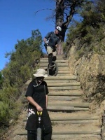
Trail around Lion's Head that links up Pat's Track on the Signal Hill side and Kloof Road on Camps Bay/The Glen on the other side. Ride-able in both direction with a couple of short portages up some steps.

Access Info

Signage on Kloof road at the hairpin bent, or accessable from Pat's Track at the kramat between Lion's Head & Signal Hill saddle.

Recent Activity on Trail

Past Week
  • 2 rides
  • 32 miles average
6 Months
  • 3 rides
  • 32 miles avg distance
All
  • 26 rides
  • Last: Jun 12, 2026
c1c2c3c4
January
February
March
April
May
June
July
August
September
October
November
December
update trails status or condition

Lions Head Trail Reports

statusdatedescription
Feb 20, 2025 @ 11:35am
Feb 20, 2025
The part of the trial after meeting with Top Rd is not that mtb friendly anymore. To many washed out stairs to be able to climb with mtb. The last...
Jan 12, 2025 @ 8:51am
Jan 12, 2025
End section down towards The Glen has some dangerous steel pins protruding. Take care not to impale yourself or destroy a tire / wheel.
Jan 7, 2023 @ 1:52am
Jan 7, 2023
Section at the water bars is in need of work...
Oct 15, 2022 @ 11:32pm
Oct 15, 2022
Leaking valve box next to trail. At last bench on the Kloof Nek road end...
Sep 11, 2022 @ 6:30am
Sep 11, 2022
Water bar section requires a bit of maintenance... Otherwise all good
more »
Status:
on Feb 20, 2025
Dry
Avg: 3.36 (2 votes)
Your vote: 0

view (866)
close
3D
Trail Conditions
  • Unknown
  • Snow Groomed
  • Snow Packed
  • Snow Covered
  • Snow Cover Partial
  • Freeze/thaw Cycle
  • Icy
  • Prevalent Mud
  • Wet
  • Variable
  • Ideal
  • Dry
  • Very Dry
Trail Flow (Ridden Direction)
Trailforks scans users ridelogs to determine the most popular direction each trail is ridden. A good flowing trail network will have most trails flowing in a single direction according to their intension.
The colour categories are based on what percentage of riders are riding a trail in its intended direction.
  • > 96%
  • > 90%
  • > 80%
  • > 70%
  • > 50%
  • < 50%
  • bi-directional trail
  • no data
Trail Last Ridden
Trailforks scans ridelogs to determine the last time a trail was ridden.
  • < 2 days
  • < 1 week
  • < 2 weeks
  • < 1 month
  • < 6 months
  • > 6 months
Trail Ridden Direction
The intended direction a trail should be ridden.
  • Downhill Only
  • Downhill Primary
  • Both Directions
  • Uphill Primary
  • Uphill Only
  • One Direction
Contribute Details
Colors indicate trail is missing specified detail.
  • Description
  • Photos
  • Description & Photos
  • Videos
Trail Popularity ?
Trailforks scans ridelogs to determine which trails are ridden the most in the last 9 months. Trails are compared with nearby trails in the same city region with a possible 25 colour shades. Think of this as a heatmap, more rides = more kinetic energy = warmer colors.
  • most popular
  • popular
  • less popular
  • not popular
ATV/ORV/OHV Filter
Max Vehicle Width
inches
US Cell Coverage
Legend
cell carrier legend

Radar Time
Activity Recordings
Trailforks uses anonymized public activity data. ?
Activity Recordings
Trailforks uses anonymized public activity data. ?
Personal Heatmap
Activity Types
all / none
Options
2
Date range month
Winter Trails
Warning A routing network for winter maps does not exist. Selecting trails using the winter trails layer has been disabled.
Missing Trails
Most Popular
Least Popular
Trails are colored based on popularity. The more popular a trail is, the more red. Less popular trails trend towards green.
Jump Magnitude Heatmap
Heatmap of where riders jump on trails. Zoom in to see individual jumps, click circles to view jump details.
BC Backroad Status

Service Road Atlas is a free to use, community-driven service for viewing and creating reports on the numerous back-country service roads around B.C. and Alberta.

map legend
Slope Aspect
Direction the slope faces
Flat N NE E SE S SW W NW
Trails Deemphasized
Trails are shown in grey.
disable
Only show trails with no bike usage.
Enable
Suggested Layers
Based on selected activity type

    Save the current map location and zoom level as your default home location whenever this page is loaded.

    Save
        Directions to lions-head trailhead (-33.942680, 18.388140)

        Photos

        8 more »
        179 |
        Jan 20, 2020 @ 2:54am
        Jan 20, 2020
        144 |
        Jan 20, 2020 @ 2:54am
        Jan 20, 2020
        216 |
        Jan 20, 2020 @ 2:54am
        Jan 20, 2020
        177 |
        Jan 14, 2020 @ 2:17am
        Jan 14, 2020

        Videos

        1 more »
        MUni - Lions Loop Cape Town
        0:15 | 192 | Jul 7, 2009 , Cape Town

        Routes with this trail

        12 miles 2,734 ft 5 Loop
        Start at the Cape Wheel, follow the route and end at the Cape Wheel

        2 Reviews & Comments


        We hope you've been enjoying Trailforks!

        Create a FREE account to view trail comments and much more.

        • By bestbeforedead & contributors
        • #196395 - 4,933 views

        Frequently Asked Questions About Lions Head

        Where is Lions Head located?
        Lions Head is located in Lion's Head & Signal Hill, Cape Town, South Africa. It is part of the Lion's Head & Signal Hill trail network. The trailhead is located at coordinates -33.94268, 18.38814.
        How hard is Lions Head?
        Lions Head is rated as Blue difficulty. The physical rating is Moderate. The average grade is 0.7%. The climb difficulty is rated Blue.
        What is the elevation gain for Lions Head?
        Lions Head has 219 ft of elevation gain. The trail has 178 ft of elevation descent. The elevation ranges from 591 ft to 728 ft.
        Is Lions Head a point to point trail?
        Lions Head is not a point to point trail. The direction is Both Directions. The trail type is singletrack.

        Hit the Trail

        Open in App

        Get this trail on your phone instantly.
        open trail in app

        Download Trail

        Save to wishlist, Garmin & download.
        save the trail

        Find Related Routes

        Find routes and users activities that include this trail.
        find routes for this trail

        You must enter a description before submitting.