more stats
2,743 ft
Distance
10 ft
Climb
-210 ft
Descent
00:04:05
Avg time
-201 ft
Altitude change
357 ft
Altitude min
558 ft
Altitude max
558 ft
Altitude start
358 ft
Altitude end
-7.3%
Grade
-36.5%
Grade max
7%
Grade min
387 ft
Distance climb
2,054 ft
Distance down
174 ft
Distance flat
00:04:05
Avg time

Liquid Bread Details

  • Activities
    • Mountain Bike
    • Hike
    • Trail Running
  • Riding Area
    Lord Hill Regional Park
    Snohomish, Washington
  • Difficulty Rating
  • Voted Difficulty
    Green (1 vote)
  • Local Popularity
    70 in Mountain Biking [+]
    • 55 in Trail Running
    • 45 in Hiking
  • Global Ranking
    #71340 in Mountain Biking [+]
    • #82544 in Trail Running
    • #96514 in Hiking
  • Trail Type
    Singletrack
  • Bike Type
    AM, XC
  • Climb Difficulty
    Blue
  • Physical Rating
    Moderate
  • Dogs Allowed
    Yes
  • eBike Allowed
  • Land Owner
    Snohomish County Parks & Recreation

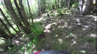
Techy trail with a little bit of everything. Rooty sections, fast and open sections, slow and twisty sections, it's all there. Most ride it downhill, but it can be ridden uphill as a gnarly climb.

Access Info

Begin riding Liquid Bread from the Cuttoff trail. Trail descends to the Main Trail.

Local Trail Association
Traditionally Indigenous Territory

Recent Activity on Trail

Past Week
  • 11 rides
  • 12 miles average
6 Months
  • 123 rides
  • 10 miles avg distance
All
  • 903 rides
  • Last: Jun 27, 2026
c1c2c3c4
January
February
March
April
May
June
July
August
September
October
November
December
update trails status or condition

Liquid Bread Trail Reports

statusdatedescription
Jun 21, 2026 @ 8:05am (America/Vancouver)
Jun 21, 2026
[L=https://www.evergreenmtb.org/trails/ride-reports/rr-9656]Evergreen MTB Report[/L]
Jun 2, 2026 @ 8:25am (America/Vancouver)
Jun 2, 2026
Running great, Even over the roots! [L=https://www.evergreenmtb.org/trails/ride-reports/rr-9626]Evergreen MTB Report[/L]
May 29, 2026 @ 6:56pm (America/Los_Angeles)
May 29, 2026
Brushed and leaf blown
Apr 17, 2026 @ 1:42pm (America/Vancouver)
Apr 17, 2026
[L=https://www.evergreenmtb.org/trails/ride-reports/rr-9557]Evergreen MTB Report[/L]
Mar 23, 2026 @ 8:30am (America/Vancouver)
Mar 23, 2026
Wet roots. [L=https://www.evergreenmtb.org/trails/ride-reports/rr-9512]EvergreenMTB Trail Report[/L]
more »
Status:
on Jun 21, 2026
Ideal
Avg: 3.94 (14 votes)
Your vote: 0

view (2,705)
close
3D
Trail Conditions
  • Unknown
  • Snow Groomed
  • Snow Packed
  • Snow Covered
  • Snow Cover Partial
  • Freeze/thaw Cycle
  • Icy
  • Prevalent Mud
  • Wet
  • Variable
  • Ideal
  • Dry
  • Very Dry
Trail Flow (Ridden Direction)
Trailforks scans users ridelogs to determine the most popular direction each trail is ridden. A good flowing trail network will have most trails flowing in a single direction according to their intension.
The colour categories are based on what percentage of riders are riding a trail in its intended direction.
  • > 96%
  • > 90%
  • > 80%
  • > 70%
  • > 50%
  • < 50%
  • bi-directional trail
  • no data
Trail Last Ridden
Trailforks scans ridelogs to determine the last time a trail was ridden.
  • < 2 days
  • < 1 week
  • < 2 weeks
  • < 1 month
  • < 6 months
  • > 6 months
Trail Ridden Direction
The intended direction a trail should be ridden.
  • Downhill Only
  • Downhill Primary
  • Both Directions
  • Uphill Primary
  • Uphill Only
  • One Direction
Contribute Details
Colors indicate trail is missing specified detail.
  • Description
  • Photos
  • Description & Photos
  • Videos
Trail Popularity ?
Trailforks scans ridelogs to determine which trails are ridden the most in the last 9 months. Trails are compared with nearby trails in the same city region with a possible 25 colour shades. Think of this as a heatmap, more rides = more kinetic energy = warmer colors.
  • most popular
  • popular
  • less popular
  • not popular
ATV/ORV/OHV Filter
Max Vehicle Width
inches
US Cell Coverage
Legend
cell carrier legend

Radar Time
Activity Recordings
Trailforks uses anonymized public activity data. ?
Activity Recordings
Trailforks uses anonymized public activity data. ?
Personal Heatmap
Activity Types
all / none
Options
2
Date range month
Winter Trails
Warning A routing network for winter maps does not exist. Selecting trails using the winter trails layer has been disabled.
Missing Trails
Most Popular
Least Popular
Trails are colored based on popularity. The more popular a trail is, the more red. Less popular trails trend towards green.
Jump Magnitude Heatmap
Heatmap of where riders jump on trails. Zoom in to see individual jumps, click circles to view jump details.
BC Backroad Status

Service Road Atlas is a free to use, community-driven service for viewing and creating reports on the numerous back-country service roads around B.C. and Alberta.

map legend
Slope Aspect
Direction the slope faces
Flat N NE E SE S SW W NW
Trails Deemphasized
Trails are shown in grey.
disable
Only show trails with no bike usage.
Enable
Suggested Layers
Based on selected activity type

    Save the current map location and zoom level as your default home location whenever this page is loaded.

    Save
        Directions to liquid-bread trailhead (47.847150, -122.050680)

        Photos

        6 more »
        43 |
        Jul 13, 2024 @ 12:27pm
        Jul 13, 2024
        60 |
        Jul 13, 2024 @ 12:26pm
        Jul 13, 2024
        277 |
        May 20, 2019 @ 10:44pm
        May 20, 2019
        44 |
        May 26, 2025 @ 3:47pm
        May 26, 2025

        Videos

        2 more »
        Lord Hill Regional Park - Liquid Bread MTB
        3:12 | 473 | Aug 28, 2022 , Snohomish
        Mountain Biking Lord Hill Regional Park -...
        1155 | Sep 5, 2017 , Snohomish

        Routes with this trail

        10 miles 1,380 ft 19
        This route combines both downhill and XC trails to create the 3 longest downhill runs in the park. Expect...
        3.0 8 miles 1,392 ft 20
        This takes the easiest climb from the park's south entrance to access the core mountain bike trails. The...
        11 miles 1,641 ft 17 Loop
        A tour of the drier trails at Lord Hill. Includes downhill and XC sections.

        6 Reviews & Comments


        We hope you've been enjoying Trailforks!

        Create a FREE account to view trail comments and much more.

        Frequently Asked Questions About Liquid Bread

        Where is Liquid Bread located?
        Liquid Bread is located in Lord Hill Regional Park, Snohomish, Washington, United States. It is part of the Lord Hill Regional Park trail network. The trailhead is located at coordinates 47.84715, -122.05068.
        How hard is Liquid Bread?
        Liquid Bread is rated as Blue difficulty. The physical rating is Moderate. The average grade is 7.3%. The climb difficulty is rated Blue.
        What is the elevation gain for Liquid Bread?
        Liquid Bread has 10 ft of elevation gain. The trail has 210 ft of elevation descent. The elevation ranges from 357 ft to 558 ft.
        How long is Liquid Bread?
        Liquid Bread is 2,743 ft long. The trail type is singletrack.

        Hit the Trail

        Open in App

        Get this trail on your phone instantly.
        open trail in app

        Download Trail

        Save to wishlist, Garmin & download.
        save the trail

        Find Related Routes

        Find routes and users activities that include this trail.
        find routes for this trail

        You must enter a description before submitting.