more stats
1.8 miles
Distance
378 ft
Climb
-325 ft
Descent
00:34:33
Avg time
52 ft
Altitude change
1,518 ft
Altitude min
1,734 ft
Altitude max
1,658 ft
Altitude start
1,709 ft
Altitude end
0.6%
Grade
-46.5%
Grade max
37.4%
Grade min
3,825 ft
Distance climb
3,173 ft
Distance down
2,336 ft
Distance flat
00:34:33
Avg time

Lizard Tail Details

  • Activities
    • Mountain Bike
    • E-Bike
    • Hike
    • Trail Running
  • Riding Area
  • Difficulty Rating
  • Voted Difficulty
    Double Black Diamond (1 vote)
  • Local Popularity
    65 in Mountain Biking [+]
    • 60 in E-Biking
    • 5 in Trail Running
    • 65 in Hiking
  • Global Ranking
    #38755 in Mountain Biking [+]
    • #16830 in E-Biking
    • #55131 in Trail Running
    • #77443 in Hiking
  • Hiking SAC Scale
    T2 Mountain Hiking
  • Trail Type
    Singletrack
  • Bike Type
    XC
  • Direction
    Both Directions
  • Climb Difficulty
    Black Diamond
  • Physical Rating
    Hard
  • Trail Visibility
    Always easy to follow
  • Dogs Allowed
    Yes
  • eBike Allowed
    Yes up to Class 1
  • TTFs on Trail
    Berm, Rock Garden
  • Year Opened
    2020
  • Land Owner

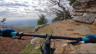
Lizard Tail runs from Sunrise to Sunset Point. It is the only black on the mountain so don’t be fooled by the rollable ribbon heading south from Sunset Point. About a mile and a half in the trail kicks it up a notch in exposure and technicality. A wet weather waterfall sprouts over the trail near the southern termination into the Shared Rim Trail.

Access Info

Access from Sunset or Sunrise Points.

Disclaimer

Beware of ICE @ water fall area in Winter

Trail Supporters

Recent Activity on Trail

Past Week
  • 1 rides
  • 11 miles average
6 Months
  • 11 rides
  • 13 miles avg distance
All
  • 108 rides
  • Last: Jun 15, 2026
c1c2c3c4
January
February
March
April
May
June
July
August
September
October
November
December
update trails status or condition

Lizard Tail Trail Reports

statusdatedescription
Dec 2, 2025 @ 2:08pm (America/Chicago)
Dec 2, 2025
Large tree down across trail, blocking trail
Oct 11, 2025 @ 9:58am (America/Indiana/Vincennes)
Oct 11, 2025
Jun 30, 2025 @ 7:11am
Jun 30, 2025
Rode next morning after a rain. Dirt was perfect. Rocks a tad slippery in places. Great ride, bring your A-Game.
Jul 6, 2024 @ 4:22pm
Jul 6, 2024
Huge tree down at intersection with the hiking trail. Hard to get bikes over - will need chainsaw.
Jul 6, 2024 @ 4:21pm
Jul 6, 2024
Huge tree down at intersection with hiking trail. Hard to get bikes over it.
more »
Status:
on Dec 2, 2025
Wet
Avg: 4.24 (7 votes)
Your vote: 0

view (499)
close
3D
Trail Conditions
  • Unknown
  • Snow Groomed
  • Snow Packed
  • Snow Covered
  • Snow Cover Partial
  • Freeze/thaw Cycle
  • Icy
  • Prevalent Mud
  • Wet
  • Variable
  • Ideal
  • Dry
  • Very Dry
Trail Flow (Ridden Direction)
Trailforks scans users ridelogs to determine the most popular direction each trail is ridden. A good flowing trail network will have most trails flowing in a single direction according to their intension.
The colour categories are based on what percentage of riders are riding a trail in its intended direction.
  • > 96%
  • > 90%
  • > 80%
  • > 70%
  • > 50%
  • < 50%
  • bi-directional trail
  • no data
Trail Last Ridden
Trailforks scans ridelogs to determine the last time a trail was ridden.
  • < 2 days
  • < 1 week
  • < 2 weeks
  • < 1 month
  • < 6 months
  • > 6 months
Trail Ridden Direction
The intended direction a trail should be ridden.
  • Downhill Only
  • Downhill Primary
  • Both Directions
  • Uphill Primary
  • Uphill Only
  • One Direction
Contribute Details
Colors indicate trail is missing specified detail.
  • Description
  • Photos
  • Description & Photos
  • Videos
Trail Popularity ?
Trailforks scans ridelogs to determine which trails are ridden the most in the last 9 months. Trails are compared with nearby trails in the same city region with a possible 25 colour shades. Think of this as a heatmap, more rides = more kinetic energy = warmer colors.
  • most popular
  • popular
  • less popular
  • not popular
ATV/ORV/OHV Filter
Max Vehicle Width
inches
US Cell Coverage
Legend
cell carrier legend

Radar Time
Activity Recordings
Trailforks uses anonymized public activity data. ?
Activity Recordings
Trailforks uses anonymized public activity data. ?
Personal Heatmap
Activity Types
all / none
Options
2
Date range month
Winter Trails
Warning A routing network for winter maps does not exist. Selecting trails using the winter trails layer has been disabled.
Missing Trails
Most Popular
Least Popular
Trails are colored based on popularity. The more popular a trail is, the more red. Less popular trails trend towards green.
Jump Magnitude Heatmap
Heatmap of where riders jump on trails. Zoom in to see individual jumps, click circles to view jump details.
BC Backroad Status

Service Road Atlas is a free to use, community-driven service for viewing and creating reports on the numerous back-country service roads around B.C. and Alberta.

map legend
Slope Aspect
Direction the slope faces
Flat N NE E SE S SW W NW
Trails Deemphasized
Trails are shown in grey.
disable
Only show trails with no bike usage.
Enable
Suggested Layers
Based on selected activity type

    Save the current map location and zoom level as your default home location whenever this page is loaded.

    Save
        Directions to lizard-tail trailhead (35.230310, -93.259000)

        Photos

        16 more »
        49 |
        Oct 11, 2025 @ 7:21pm
        Oct 11, 2025
        61 |
        Oct 11, 2025 @ 7:21pm
        Oct 11, 2025
        140 |
        Jul 25, 2023 @ 6:29pm
        Jul 25, 2023
        158 |
        Jul 25, 2023 @ 6:28pm
        Jul 25, 2023

        Videos

        1 more »
        Scenic & Technical MTB Trails at Mt. Nebo...
        13:14 | 187 | Dec 15, 2024 , Dardanelle

        Routes with this trail

        5.0 14 miles 2,400 ft 6
        What an amazing TOTAL PACKAGE at Mt. Nebo. Amazing views, great trailwork, challenging features, blazing...
        5.0 15 miles 2,492 ft 8
        All of the blacks, all of the blues, and most of the miles.
        1.0 20 miles 2,958 ft 9
        A compilation route of the majority of the trails. Helpful if you are just driving in for the day or...

        5 Reviews & Comments


        We hope you've been enjoying Trailforks!

        Create a FREE account to view trail comments and much more.

        • By ArkansasJoe CATA ARSP & contributors
        • #297439 - 4,032 views

        Frequently Asked Questions About Lizard Tail

        Where is Lizard Tail located?
        Lizard Tail is located in Mount Nebo State Park - Monument Trails, Dardanelle, Arkansas, United States. It is part of the Mount Nebo State Park - Monument Trails trail network. The trailhead is located at coordinates 35.23031, -93.259.
        How hard is Lizard Tail?
        Lizard Tail is rated as Black Diamond difficulty. The physical rating is Hard. The average grade is 0.6%. The climb difficulty is rated Black Diamond.
        What is the elevation gain for Lizard Tail?
        Lizard Tail has 378 ft of elevation gain. The trail has 325 ft of elevation descent. The elevation ranges from 1,518 ft to 1,734 ft.
        Is Lizard Tail a point to point trail?
        Lizard Tail is not a point to point trail. The direction is Both Directions. The trail type is singletrack.

        Hit the Trail

        Open in App

        Get this trail on your phone instantly.
        open trail in app

        Download Trail

        Save to wishlist, Garmin & download.
        save the trail

        Find Related Routes

        Find routes and users activities that include this trail.
        find routes for this trail

        You must enter a description before submitting.