more stats
2.9 miles
Distance
198 ft
Climb
-261 ft
Descent
00:37:22
Avg time
-62 ft
Altitude change
4,318 ft
Altitude min
4,445 ft
Altitude max
4,386 ft
Altitude start
4,324 ft
Altitude end
-0.4%
Grade
-14%
Grade max
16.4%
Grade min
4,482 ft
Distance climb
1 mile
Distance down
4,531 ft
Distance flat
00:37:22
Avg time

Llama Details

  • Activities
    • Mountain Bike
    • Adaptive Bike
    • Horse
    • Hike
    • Trail Running
  • Riding Area
    Bell Rock
    Village Of Oak Creek, Arizona
  • Difficulty Rating
  • Voted Difficulty
    Blue (3 votes)
  • Local Popularity
    80 in Mountain Biking [+]
    • 65 in Trail Running
    • 50 in Hiking
    • 5 in Horseback
  • Global Ranking
    #722 in Mountain Biking [+]
    • #19371 in Trail Running
    • #71889 in Hiking
    • #454 in Horseback
  • Trail Type
    Singletrack
  • Bike Type
  • Direction
    Both Directions
  • Dogs Allowed
    Yes
  • eBike Allowed

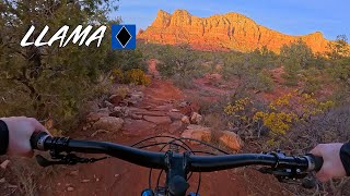
Beginner 10%, intermediate 70% and advanced 20%, 2.8 mile MTB trail which is a bi-directional singletrack that is a twisty up and down trail with several technical uphill sections that will test a lesser skilled rider. The trail tread is mostly packed dirt mixed with rocks and a number of slickrock sections. There is no preferred direction but it is somewhat easier north to south direction. The trail is a great connector for several fun loops.

Adaptive Bike Info
aMTB Blue Rating: Intermediate features and steeper terrain.

Very technical, but actually do-able solo depending on your ability. Best clockwise.

Trail Supporters

  • USFS
    Land Manager
Local Trail Association

Recent Activity on Trail

Past Week
  • 2 rides
  • 13 miles average
6 Months
  • 220 rides
  • 16 miles avg distance
All
  • 1,974 rides
  • Last: Jun 21, 2026
c1c2c3c4
January
February
March
April
May
June
July
August
September
October
November
December
Status:
on Jan 22, 2026
Ideal
Avg: 4.05 (70 votes)
Your vote: 0

view (7,905)
close
3D
Trail Conditions
  • Unknown
  • Snow Groomed
  • Snow Packed
  • Snow Covered
  • Snow Cover Partial
  • Freeze/thaw Cycle
  • Icy
  • Prevalent Mud
  • Wet
  • Variable
  • Ideal
  • Dry
  • Very Dry
Trail Flow (Ridden Direction)
Trailforks scans users ridelogs to determine the most popular direction each trail is ridden. A good flowing trail network will have most trails flowing in a single direction according to their intension.
The colour categories are based on what percentage of riders are riding a trail in its intended direction.
  • > 96%
  • > 90%
  • > 80%
  • > 70%
  • > 50%
  • < 50%
  • bi-directional trail
  • no data
Trail Last Ridden
Trailforks scans ridelogs to determine the last time a trail was ridden.
  • < 2 days
  • < 1 week
  • < 2 weeks
  • < 1 month
  • < 6 months
  • > 6 months
Trail Ridden Direction
The intended direction a trail should be ridden.
  • Downhill Only
  • Downhill Primary
  • Both Directions
  • Uphill Primary
  • Uphill Only
  • One Direction
Contribute Details
Colors indicate trail is missing specified detail.
  • Description
  • Photos
  • Description & Photos
  • Videos
Trail Popularity ?
Trailforks scans ridelogs to determine which trails are ridden the most in the last 9 months. Trails are compared with nearby trails in the same city region with a possible 25 colour shades. Think of this as a heatmap, more rides = more kinetic energy = warmer colors.
  • most popular
  • popular
  • less popular
  • not popular
ATV/ORV/OHV Filter
Max Vehicle Width
inches
US Cell Coverage
Legend
cell carrier legend

Radar Time
Activity Recordings
Trailforks uses anonymized public activity data. ?
Activity Recordings
Trailforks uses anonymized public activity data. ?
Personal Heatmap
Activity Types
all / none
Options
2
Date range month
Winter Trails
Warning A routing network for winter maps does not exist. Selecting trails using the winter trails layer has been disabled.
Missing Trails
Most Popular
Least Popular
Trails are colored based on popularity. The more popular a trail is, the more red. Less popular trails trend towards green.
Jump Magnitude Heatmap
Heatmap of where riders jump on trails. Zoom in to see individual jumps, click circles to view jump details.
BC Backroad Status

Service Road Atlas is a free to use, community-driven service for viewing and creating reports on the numerous back-country service roads around B.C. and Alberta.

map legend
Slope Aspect
Direction the slope faces
Flat N NE E SE S SW W NW
Trails Deemphasized
Trails are shown in grey.
disable
Only show trails with no bike usage.
Enable
Suggested Layers
Based on selected activity type

    Save the current map location and zoom level as your default home location whenever this page is loaded.

    Save
        Directions to llama trailhead (34.805330, -111.761780)

        Photos

        54 more »
        1,282 |
        Jan 18, 2018 @ 8:03am
        Jan 18, 2018
        1,755 |
        Mar 20, 2016 @ 9:33pm
        Mar 20, 2016
        1,273 |
        Sep 15, 2016 @ 2:31pm
        Sep 15, 2016
        398 |
        Dec 4, 2018 @ 10:07pm
        Dec 4, 2018

        Videos

        15 more »
        youtuber ☀️ Arizona #03 - Sedona for beginners -...
        15:27 | 1188 | May 14, 2019 , Village Of Oak Creek
        youtuber Roam Fest Sedona Day 3 | LLAMA TRAIL (GoPro 8)
        14:34 | 751 | Nov 26, 2019 , Village Of Oak Creek
        youtuber Sedona's Hogs Trails are awesome! | Mountain...
        36:46 | 28 | Apr 24, 2026 , Village Of Oak Creek
        LLAMA | Sedona, AZ
        6:05 | 160 | Apr 26, 2025 , Village Of Oak Creek

        Routes with this trail

        4.0 10 miles 897 ft 7 Loop
        Sedona Classics! Featuring some long standing favorites like Slim Shady, , Llama, and trails. There are a...
        5.0 11 miles 945 ft 4 Loop
        Fun loop including my favorite trail . Definitely one that will make you work at times but well worth it....
        5.0 53 miles 5,619 ft 24
        This is for the AES BFL for the year 2021

        12 Reviews & Comments


        We hope you've been enjoying Trailforks!

        Create a FREE account to view trail comments and much more.

        • By toddTF Pro Trailforks & contributors
        • #14546 - 14,488 views

        Frequently Asked Questions About Llama

        Where is Llama located?
        Llama is located in Bell Rock, Village Of Oak Creek, Arizona, United States. It is part of the Bell Rock trail network. The trailhead is located at coordinates 34.80533, -111.76178.
        How hard is Llama?
        Llama is rated as Blue difficulty. The average grade is 0.4%.
        What is the elevation gain for Llama?
        Llama has 198 ft of elevation gain. The trail has 261 ft of elevation descent. The elevation ranges from 4,318 ft to 4,445 ft.
        Is Llama a point to point trail?
        Llama is not a point to point trail. The direction is Both Directions. The trail type is singletrack.

        Hit the Trail

        Open in App

        Get this trail on your phone instantly.
        open trail in app

        Download Trail

        Save to wishlist, Garmin & download.
        save the trail

        Find Related Routes

        Find routes and users activities that include this trail.
        find routes for this trail

        You must enter a description before submitting.