more stats
1.2 miles
Distance
-560 ft
Descent
00:08:53
Avg time
-560 ft
Altitude change
1,471 ft
Altitude min
2,032 ft
Altitude max
2,032 ft
Altitude start
1,473 ft
Altitude end
-8.8%
Grade
-35.5%
Grade max
3.1%
Grade min
43 ft
Distance climb
1 mile
Distance down
194 ft
Distance flat
00:08:53
Avg time

Lo Búnker Details

  • Activities
    • Mountain Bike
    • E-Bike
    • Hike
    • Trail Running
  • Riding Area
  • Difficulty Rating
  • Local Popularity
    75 in Mountain Biking [+]
    • 85 in E-Biking
    • 95 in Trail Running
    • 85 in Hiking
  • Global Ranking
    #14062 in Mountain Biking [+]
    • #25499 in E-Biking
    • #19744 in Trail Running
    • #37059 in Hiking
  • Trail Type
    Singletrack
  • Bike Type
    AM, XC
  • Direction
    Downhill Primary
    Popular Direction Shown
  • Climb Difficulty
    Green
  • Physical Rating
    Moderate
  • Trail Visibility
    Always easy to follow
  • Dogs Allowed
    Yes
  • eBike Allowed
    Yes up to Class 1
  • Land Owner
    Associació Lo Podall

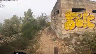
Sender uneix la pista del carener amb la Central Hidroelèctrica passant per Comportes de St. Antoni i el Búnquer de la guerra civil. Després del búnquer hi ha una baixada pronunciada que en dies de fang pot donar problemes, es pot esquivar baixant per la pista. La resta es terreny rocós i sorrenc que drena molt bé l'aigua.

Local Trail Association

Recent Activity on Trail

Past Week
  • 0 rides
  •  
6 Months
  • 19 rides
  • 18 miles avg distance
All
  • 90 rides
  • Last: Apr 24, 2026
c1c2c3c4
January
February
March
April
May
June
July
August
September
October
November
December
Status:
on Apr 24, 2026
Ideal
Avg: 4.09 (5 votes)
Your vote: 0

view (803)
close
3D
Trail Conditions
  • Unknown
  • Snow Groomed
  • Snow Packed
  • Snow Covered
  • Snow Cover Partial
  • Freeze/thaw Cycle
  • Icy
  • Prevalent Mud
  • Wet
  • Variable
  • Ideal
  • Dry
  • Very Dry
Trail Flow (Ridden Direction)
Trailforks scans users ridelogs to determine the most popular direction each trail is ridden. A good flowing trail network will have most trails flowing in a single direction according to their intension.
The colour categories are based on what percentage of riders are riding a trail in its intended direction.
  • > 96%
  • > 90%
  • > 80%
  • > 70%
  • > 50%
  • < 50%
  • bi-directional trail
  • no data
Trail Last Ridden
Trailforks scans ridelogs to determine the last time a trail was ridden.
  • < 2 days
  • < 1 week
  • < 2 weeks
  • < 1 month
  • < 6 months
  • > 6 months
Trail Ridden Direction
The intended direction a trail should be ridden.
  • Downhill Only
  • Downhill Primary
  • Both Directions
  • Uphill Primary
  • Uphill Only
  • One Direction
Contribute Details
Colors indicate trail is missing specified detail.
  • Description
  • Photos
  • Description & Photos
  • Videos
Trail Popularity ?
Trailforks scans ridelogs to determine which trails are ridden the most in the last 9 months. Trails are compared with nearby trails in the same city region with a possible 25 colour shades. Think of this as a heatmap, more rides = more kinetic energy = warmer colors.
  • most popular
  • popular
  • less popular
  • not popular
ATV/ORV/OHV Filter
Max Vehicle Width
inches
US Cell Coverage
Legend
cell carrier legend

Radar Time
Activity Recordings
Trailforks uses anonymized public activity data. ?
Activity Recordings
Trailforks uses anonymized public activity data. ?
Personal Heatmap
Activity Types
all / none
Options
2
Date range month
Winter Trails
Warning A routing network for winter maps does not exist. Selecting trails using the winter trails layer has been disabled.
Missing Trails
Most Popular
Least Popular
Trails are colored based on popularity. The more popular a trail is, the more red. Less popular trails trend towards green.
Jump Magnitude Heatmap
Heatmap of where riders jump on trails. Zoom in to see individual jumps, click circles to view jump details.
BC Backroad Status

Service Road Atlas is a free to use, community-driven service for viewing and creating reports on the numerous back-country service roads around B.C. and Alberta.

map legend
Slope Aspect
Direction the slope faces
Flat N NE E SE S SW W NW
Trails Deemphasized
Trails are shown in grey.
disable
Only show trails with no bike usage.
Enable
Suggested Layers
Based on selected activity type

    Save the current map location and zoom level as your default home location whenever this page is loaded.

    Save
        Directions to lo-bunker trailhead (42.173400, 0.922980)

        Photos

        5 more »
        72 |
        May 18, 2024 @ 1:49am
        May 18, 2024
        77 |
        Jun 3, 2023 @ 5:03am
        Jun 3, 2023
        87 |
        Feb 25, 2023 @ 12:08pm
        Feb 25, 2023
        115 |
        Jul 25, 2022 @ 6:16am
        Jul 25, 2022

        Videos

        1 more »
        Lo Búnker by Territori Lo Podall
        5:48 | 344 | Nov 23, 2023 , Tremp

        Routes with this trail

        4.0 17 miles 2,927 ft 10 Loop
        Ruta molt a prop de Tremp, amb bones vistes i terreny ideal en dies d'humitat. Sense grans pujades però...

        2 Reviews & Comments


        We hope you've been enjoying Trailforks!

        Create a FREE account to view trail comments and much more.

        Frequently Asked Questions About Lo Búnker

        Where is Lo Búnker located?
        Lo Búnker is located in Territori Lo Podall Tremp, Tremp, Spain. It is part of the Territori Lo Podall Tremp trail network. The trailhead is located at coordinates 42.1734, 0.92298.
        How hard is Lo Búnker?
        Lo Búnker is rated as Blue difficulty. The physical rating is Moderate. The average grade is 8.8%. The climb difficulty is rated Green.
        What is the elevation gain for Lo Búnker?
        The trail has 560 ft of elevation descent. The elevation ranges from 1,471 ft to 2,032 ft.
        Is Lo Búnker a point to point trail?
        Lo Búnker is not a point to point trail. The direction is Downhill Primary. The trail type is singletrack.

        Hit the Trail

        Open in App

        Get this trail on your phone instantly.
        open trail in app

        Download Trail

        Save to wishlist, Garmin & download.
        save the trail

        Find Related Routes

        Find routes and users activities that include this trail.
        find routes for this trail

        You must enter a description before submitting.