more stats
2.3 miles
Distance
17 ft
Climb
-407 ft
Descent
00:13:32
Avg time
-389 ft
Altitude change
1,432 ft
Altitude min
1,822 ft
Altitude max
1,821 ft
Altitude start
1,430 ft
Altitude end
-3.2%
Grade
-22.8%
Grade max
5.3%
Grade min
1,375 ft
Distance climb
2 miles
Distance down
1,509 ft
Distance flat
00:13:32
Avg time

Lonberger Path Details

  • Activities
    • Mountain Bike
    • E-Bike
    • Hike
    • Trail Running
  • Riding Area
    Galbraith Gap (Rothrock State Forest)
    State College, Pennsylvania
  • Difficulty Rating
  • Voted Difficulty
    Blue (2 votes)
  • Local Popularity
    100 in Mountain Biking [+]
    • 100 in E-Biking
    • 95 in Trail Running
    • 95 in Hiking
  • Global Ranking
    #33656 in Mountain Biking [+]
    • #1052 in Trail Running
    • #4305 in Hiking
  • Trail Type
    Singletrack
  • Bike Type
    AM, XC, Fat
  • Direction
    Both Directions
    Popular Direction Shown
  • Climb Difficulty
    Blue
  • Physical Rating
    Moderate
  • Season
    All Year
  • Dogs Allowed
    Yes
  • eBike Allowed
  • Land Owner

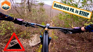
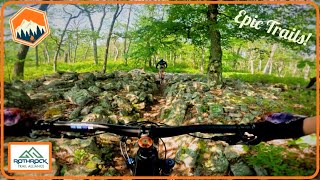
Also known as the magic carpet ride this in the down direction is a fun fast flowing trail that end with a short fast drop down the "yellow brick rd" (a rock armoured section) just before Laurel Run Rd. This is a great beginner through experienced individual trail that is a great end to any ride. Going up you will lose a lung climbing the "yellow brick rd" but then it is a gradual warm. The section before/after the intersection with Kettle Trail is definitely more challenging and is black diamond

Access Info

Off Laurel Run Rd of from Kettle trail or North Meadows Rd

Trail Supporters
Local Trail Association
Traditionally Indigenous Territory

Recent Activity on Trail

Past Week
  • 5 rides
  • 17 miles average
6 Months
  • 71 rides
  • 14 miles avg distance
All
  • 716 rides
  • Last: Jul 4, 2026
c1c2c3c4
January
February
March
April
May
June
July
August
September
October
November
December
update trails status or condition

Lonberger Path Trail Reports

Status:
on May 5, 2026
Ideal
Avg: 4.38 (12 votes)
Your vote: 0

view (3,483)
close
3D
Trail Conditions
  • Unknown
  • Snow Groomed
  • Snow Packed
  • Snow Covered
  • Snow Cover Partial
  • Freeze/thaw Cycle
  • Icy
  • Prevalent Mud
  • Wet
  • Variable
  • Ideal
  • Dry
  • Very Dry
Trail Flow (Ridden Direction)
Trailforks scans users ridelogs to determine the most popular direction each trail is ridden. A good flowing trail network will have most trails flowing in a single direction according to their intension.
The colour categories are based on what percentage of riders are riding a trail in its intended direction.
  • > 96%
  • > 90%
  • > 80%
  • > 70%
  • > 50%
  • < 50%
  • bi-directional trail
  • no data
Trail Last Ridden
Trailforks scans ridelogs to determine the last time a trail was ridden.
  • < 2 days
  • < 1 week
  • < 2 weeks
  • < 1 month
  • < 6 months
  • > 6 months
Trail Ridden Direction
The intended direction a trail should be ridden.
  • Downhill Only
  • Downhill Primary
  • Both Directions
  • Uphill Primary
  • Uphill Only
  • One Direction
Contribute Details
Colors indicate trail is missing specified detail.
  • Description
  • Photos
  • Description & Photos
  • Videos
Trail Popularity ?
Trailforks scans ridelogs to determine which trails are ridden the most in the last 9 months. Trails are compared with nearby trails in the same city region with a possible 25 colour shades. Think of this as a heatmap, more rides = more kinetic energy = warmer colors.
  • most popular
  • popular
  • less popular
  • not popular
ATV/ORV/OHV Filter
Max Vehicle Width
inches
US Cell Coverage
Legend
cell carrier legend

Radar Time
Activity Recordings
Trailforks uses anonymized public activity data. ?
Activity Recordings
Trailforks uses anonymized public activity data. ?
Personal Heatmap
Activity Types
all / none
Options
2
Date range month
Winter Trails
Warning A routing network for winter maps does not exist. Selecting trails using the winter trails layer has been disabled.
Missing Trails
Most Popular
Least Popular
Trails are colored based on popularity. The more popular a trail is, the more red. Less popular trails trend towards green.
Jump Magnitude Heatmap
Heatmap of where riders jump on trails. Zoom in to see individual jumps, click circles to view jump details.
BC Backroad Status

Service Road Atlas is a free to use, community-driven service for viewing and creating reports on the numerous back-country service roads around B.C. and Alberta.

map legend
Slope Aspect
Direction the slope faces
Flat N NE E SE S SW W NW
Trails Deemphasized
Trails are shown in grey.
disable
Only show trails with no bike usage.
Enable
Suggested Layers
Based on selected activity type

    Save the current map location and zoom level as your default home location whenever this page is loaded.

    Save
        Directions to lonberger-path trailhead (40.746060, -77.747140)

        Photos

        44 more »
        77 |
        Aug 3, 2024 @ 10:30am
        Aug 3, 2024
        78 |
        Aug 3, 2024 @ 10:29am
        Aug 3, 2024
        81 |
        Jun 16, 2023 @ 3:48pm
        Jun 16, 2023
        73 |
        Jun 16, 2023 @ 3:48pm
        Jun 16, 2023

        Videos

        7 more »
        This place gets SKETCHY!  Rothrock state...
        12:57 | 66 | Jul 8, 2025 , State College
        State College Has Some Awesome Trails!...
        10:30 | 38 | Jul 8, 2025 , State College
        Rothrocks Backcountry Riding is Epic!
        15:08 | 14 | Jul 8, 2025 , State College
        Rothrock Levo 10.19.24
        100 | Oct 30, 2024 , State College

        Routes with this trail

        3.7 35 miles 4,277 ft 25 Loop
        Overview The 36-mile Rothrock TrailMix course provides a combination of some of the best trails within...
        5.0 32 miles 3,886 ft 18
        This is a close relative to the Rothrock TrailMix NMBA Epic, but with two changes: one, it starts in a...
        4.7 12 miles 1,029 ft 11 Loop
        This is a staple loop of the area typically run in the direction of up , left up to to the Beer Tap,...

        Trail Products

        6 Reviews & Comments


        We hope you've been enjoying Trailforks!

        Create a FREE account to view trail comments and much more.

        • By SaclydesdaleTF Pro NMBA & contributors
        • #21768 - 4,991 views

        Frequently Asked Questions About Lonberger Path

        Where is Lonberger Path located?
        Lonberger Path is located in Galbraith Gap (Rothrock State Forest), State College, Pennsylvania, United States. It is part of the Galbraith Gap (Rothrock State Forest) trail network. The trailhead is located at coordinates 40.74606, -77.74714.
        How hard is Lonberger Path?
        Lonberger Path is rated as Blue difficulty. The physical rating is Moderate. The average grade is 3.2%. The climb difficulty is rated Blue.
        What is the elevation gain for Lonberger Path?
        Lonberger Path has 5 m of elevation gain. The trail has 124 m of elevation descent. The elevation ranges from 436 m to 555 m.
        Is Lonberger Path a point to point trail?
        Lonberger Path is not a point to point trail. The direction is Both Directions. The trail type is singletrack.

        Hit the Trail

        Open in App

        Get this trail on your phone instantly.
        open trail in app

        Download Trail

        Save to wishlist, Garmin & download.
        save the trail

        Find Related Routes

        Find routes and users activities that include this trail.
        find routes for this trail

        You must enter a description before submitting.