more stats
4,516 ft
Distance
127 ft
Climb
-122 ft
Descent
00:10:01
Avg time
6 ft
Altitude change
4,710 ft
Altitude min
4,777 ft
Altitude max
4,717 ft
Altitude start
4,723 ft
Altitude end
0.127%
Grade
-20.713%
Grade max
16.205%
Grade min
1,461 ft
Distance climb
1,642 ft
Distance down
1,414 ft
Distance flat
00:10:01
Avg time

Lone Peak Details

  • Activities
    • Mountain Bike
    • Hike
    • Trail Running
  • Riding Area
    Highland Hollow
    Highland UT, Utah
  • Difficulty Rating
  • Local Popularity
    50 in Mountain Biking [+]
    • 5 in Trail Running
    • 5 in Hiking
  • Global Ranking
    #121406 in Mountain Biking [+]
    • #263934 in Trail Running
    • #273750 in Hiking
  • Trail Type
    Singletrack
  • Direction
    Both Directions
  • Dogs Allowed
    Yes
  • eBike Allowed
    Yes up to Class 1

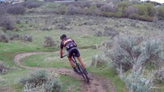
This is the part of the trail that traverses the hillside of the basin. Mostly narrow singletrack with a few sandy and wood chip sections that can make it loose. A few steep switchbacks and a wooden A-Frame in the trees make it one of the more interesting trails in the basin.

Traditionally Indigenous Territory

Recent Activity on Trail

Past Week
  • 0 rides
  •  
6 Months
  • 2 rides
  • 12 miles avg distance
All
  • 25 rides
  • Last: Jun 7, 2026
c1c2c3c4
January
February
March
April
May
June
July
August
September
October
November
December
update trails status or condition

Lone Peak Trail Reports

statusdatedescription
Apr 19, 2024 @ 7:25pm
Apr 19, 2024
Still overgrown and hard to follow. I think part of the trail has been taken over by housing.
Aug 15, 2023 @ 7:46pm
Aug 15, 2023
Over grown and hard to follow
Jun 3, 2021 @ 6:35pm
Jun 3, 2021
Dry and dusty
Jun 27, 2020 @ 6:28am
Jun 27, 2020
Some parts have a ton of Canadian thistle.
Jun 4, 2019 @ 5:55pm
Jun 4, 2019
The weeds are terribly tall and narrow to the trails. Watching riders through these trails reminds me of the raptors coming in on the park rangers...
more »
Status:
on Apr 19, 2024
Dry
Avg: 3.44 (5 votes)
Your vote: 0

view (329)
close
3D
Trail Conditions
  • Unknown
  • Snow Groomed
  • Snow Packed
  • Snow Covered
  • Snow Cover Partial
  • Freeze/thaw Cycle
  • Icy
  • Prevalent Mud
  • Wet
  • Variable
  • Ideal
  • Dry
  • Very Dry
Trail Flow (Ridden Direction)
Trailforks scans users ridelogs to determine the most popular direction each trail is ridden. A good flowing trail network will have most trails flowing in a single direction according to their intension.
The colour categories are based on what percentage of riders are riding a trail in its intended direction.
  • > 96%
  • > 90%
  • > 80%
  • > 70%
  • > 50%
  • < 50%
  • bi-directional trail
  • no data
Trail Last Ridden
Trailforks scans ridelogs to determine the last time a trail was ridden.
  • < 2 days
  • < 1 week
  • < 2 weeks
  • < 1 month
  • < 6 months
  • > 6 months
Trail Ridden Direction
The intended direction a trail should be ridden.
  • Downhill Only
  • Downhill Primary
  • Both Directions
  • Uphill Primary
  • Uphill Only
  • One Direction
Contribute Details
Colors indicate trail is missing specified detail.
  • Description
  • Photos
  • Description & Photos
  • Videos
Trail Popularity ?
Trailforks scans ridelogs to determine which trails are ridden the most in the last 9 months. Trails are compared with nearby trails in the same city region with a possible 25 colour shades. Think of this as a heatmap, more rides = more kinetic energy = warmer colors.
  • most popular
  • popular
  • less popular
  • not popular
ATV/ORV/OHV Filter
Max Vehicle Width
inches
US Cell Coverage
Legend
cell carrier legend

Radar Time
Activity Recordings
Trailforks uses anonymized public activity data. ?
Activity Recordings
Trailforks uses anonymized public activity data. ?
Personal Heatmap
Activity Types
all / none
Options
2
Date range month
Winter Trails
Warning A routing network for winter maps does not exist. Selecting trails using the winter trails layer has been disabled.
Missing Trails
Most Popular
Least Popular
Trails are colored based on popularity. The more popular a trail is, the more red. Less popular trails trend towards green.
Jump Magnitude Heatmap
Heatmap of where riders jump on trails. Zoom in to see individual jumps, click circles to view jump details.
BC Backroad Status

Service Road Atlas is a free to use, community-driven service for viewing and creating reports on the numerous back-country service roads around B.C. and Alberta.

map legend
Slope Aspect
Direction the slope faces
Flat N NE E SE S SW W NW
Trails Deemphasized
Trails are shown in grey.
disable
Only show trails with no bike usage.
Enable
Suggested Layers
Based on selected activity type

    Save the current map location and zoom level as your default home location whenever this page is loaded.

    Save
        Directions to lone-peak trailhead (40.425355, -111.824167)

        Photos

        4 more »
        188 |
        Oct 24, 2016 @ 8:56am
        Oct 24, 2016
        240 |
        Oct 24, 2016 @ 8:55am
        Oct 24, 2016
        205 |
        Oct 24, 2016 @ 8:55am
        Oct 24, 2016
        171 |
        Oct 24, 2016 @ 8:55am
        Oct 24, 2016

        Videos

        1 more »
        Highland Hollow trails
        1224 | Apr 27, 2017 , Highland UT

        5 Reviews & Comments


        We hope you've been enjoying Trailforks!

        Create a FREE account to view trail comments and much more.

        • By toddTF Pro Trailforks & contributors
        • #72121 - 2,434 views

        Frequently Asked Questions About Lone Peak

        Where is Lone Peak located?
        Lone Peak is located in Highland Hollow, Highland UT, Utah, United States. It is part of the Highland Hollow trail network. The trailhead is located at coordinates 40.42536, -111.82417.
        How hard is Lone Peak?
        Lone Peak is rated as Blue difficulty. The average grade is 0.127%.
        What is the elevation gain for Lone Peak?
        Lone Peak has 127 ft of elevation gain. The trail has 122 ft of elevation descent. The elevation ranges from 4,710 ft to 4,777 ft.
        Is Lone Peak a point to point trail?
        Lone Peak is not a point to point trail. The direction is Both Directions. The trail type is singletrack.

        Hit the Trail

        Open in App

        Get this trail on your phone instantly.
        open trail in app

        Download Trail

        Save to wishlist, Garmin & download.
        save the trail

        Find Related Routes

        Find routes and users activities that include this trail.
        find routes for this trail

        You must enter a description before submitting.