more stats
4,570 ft
Distance
-873 ft
Descent
00:06:47
Avg time
-875 ft
Altitude change
4,213 ft
Altitude min
5,088 ft
Altitude max
5,088 ft
Altitude start
4,213 ft
Altitude end
-19.1%
Grade
-76.1%
Grade max
-1.7%
Grade min
4,537 ft
Distance down
33 ft
Distance flat
00:06:47
Avg time

Look Out Details

  • Activities
    • Mountain Bike
    • E-Bike
  • Riding Area
    Panorama Mountain Resort
    Panorama, British Columbia
  • Difficulty Rating
  • Local Popularity
    90 in Mountain Biking [+]
    • 90 in E-Biking
  • Global Ranking
    #40447 in Mountain Biking [+]
    • #39140 in E-Biking
  • Trail Type
    Singletrack
  • Bike Type
    DH
  • Direction
    Downhill Only
    Popular Direction Shown
  • Trail Visibility
    Always easy to follow
  • eBike Allowed
    Yes up to Class 1
  • TTFs on Trail
    Berm, Drop, Jump, Ladder Bridge, Rock Garden
  • Land Owner

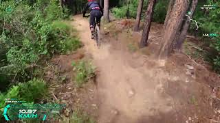
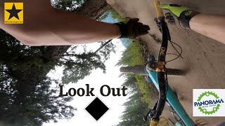
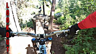
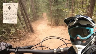
Upper: Steep technical section, wood features, roots, rocks, feeding into fast flowy flat corner section. Lower: Fast single track with a bit of everything. Berms, roots, rocks and features. True blue tech.

Bike Park

Recent Activity on Trail

Past Week
  • 0 rides
  •  
6 Months
  • 0 rides
  •  
All
  • 155 rides
  • Last: Jul 10, 2025
c1c2c3c4
January
February
March
April
May
June
July
August
September
October
November
December
update trails status or condition

Look Out Trail Reports

statusdatedescription
Sep 2, 2025 @ 9:33am
Sep 2, 2025
-- Trail Closed for the 2025 Season --
Aug 13, 2025 @ 5:28am
Aug 13, 2025
A few wet spots that you can easily go around
Jul 8, 2025 @ 10:14am
Jul 8, 2025
Jun 27, 2025 @ 7:52am
Jun 27, 2025
Apr 30, 2025 @ 6:31am
Apr 30, 2025
more »
Status:
on Jun 5, 2026
Avg: 4.36 (17 votes)
Your vote: 0

view (1,671)
close
3D
Trail Conditions
  • Unknown
  • Snow Groomed
  • Snow Packed
  • Snow Covered
  • Snow Cover Partial
  • Freeze/thaw Cycle
  • Icy
  • Prevalent Mud
  • Wet
  • Variable
  • Ideal
  • Dry
  • Very Dry
Trail Flow (Ridden Direction)
Trailforks scans users ridelogs to determine the most popular direction each trail is ridden. A good flowing trail network will have most trails flowing in a single direction according to their intension.
The colour categories are based on what percentage of riders are riding a trail in its intended direction.
  • > 96%
  • > 90%
  • > 80%
  • > 70%
  • > 50%
  • < 50%
  • bi-directional trail
  • no data
Trail Last Ridden
Trailforks scans ridelogs to determine the last time a trail was ridden.
  • < 2 days
  • < 1 week
  • < 2 weeks
  • < 1 month
  • < 6 months
  • > 6 months
Trail Ridden Direction
The intended direction a trail should be ridden.
  • Downhill Only
  • Downhill Primary
  • Both Directions
  • Uphill Primary
  • Uphill Only
  • One Direction
Contribute Details
Colors indicate trail is missing specified detail.
  • Description
  • Photos
  • Description & Photos
  • Videos
Trail Popularity ?
Trailforks scans ridelogs to determine which trails are ridden the most in the last 9 months. Trails are compared with nearby trails in the same city region with a possible 25 colour shades. Think of this as a heatmap, more rides = more kinetic energy = warmer colors.
  • most popular
  • popular
  • less popular
  • not popular
ATV/ORV/OHV Filter
Max Vehicle Width
inches
US Cell Coverage
Legend
cell carrier legend

Radar Time
Activity Recordings
Trailforks uses anonymized public activity data. ?
Activity Recordings
Trailforks uses anonymized public activity data. ?
Personal Heatmap
Activity Types
all / none
Options
2
Date range month
Winter Trails
Warning A routing network for winter maps does not exist. Selecting trails using the winter trails layer has been disabled.
Missing Trails
Most Popular
Least Popular
Trails are colored based on popularity. The more popular a trail is, the more red. Less popular trails trend towards green.
Jump Magnitude Heatmap
Heatmap of where riders jump on trails. Zoom in to see individual jumps, click circles to view jump details.
BC Backroad Status

Service Road Atlas is a free to use, community-driven service for viewing and creating reports on the numerous back-country service roads around B.C. and Alberta.

map legend
Slope Aspect
Direction the slope faces
Flat N NE E SE S SW W NW
Trails Deemphasized
Trails are shown in grey.
disable
Only show trails with no bike usage.
Enable
Suggested Layers
Based on selected activity type

    Save the current map location and zoom level as your default home location whenever this page is loaded.

    Save
        Directions to look-out trailhead (50.445330, -116.228230)

        Photos

        2 more »
        121 |
        Aug 13, 2020 @ 8:46am
        Aug 13, 2020
        149 |
        Aug 13, 2020 @ 8:46am
        Aug 13, 2020

        Videos

        6 more »
        Panorama Mountain Resort - Look Out!◇
        7:59 | 390 | Sep 22, 2022 , Panorama
        Look Out - Panorama Bike Park-With Crash!
        0:41 | 157 | Aug 23, 2022 , Panorama
        look out
        143 | Aug 31, 2021 , Panorama
        Panorama Bike Park - Look Out (New Section)
        2:06 | 425 | Sep 1, 2020 , Panorama

        Routes with this trail

        14 miles 4,343 ft 11 Race
        Boobs on Tubes enduro 2025 route
        4.7 12 miles 4,182 ft 11 Race
        Enduro route 3 option, if ready

        1 Review & Comments


        We hope you've been enjoying Trailforks!

        Create a FREE account to view trail comments and much more.

        • By Tekmisfit & contributors
        • #2442 - 3,199 views

        Frequently Asked Questions About Look Out

        Where is Look Out located?
        Look Out is located in Panorama Mountain Resort, Panorama, British Columbia, Canada. It is part of the Panorama Mountain Resort trail network. The trailhead is located at coordinates 50.44533, -116.22823.
        How hard is Look Out?
        Look Out is rated as Black Diamond difficulty. The average grade is 19.1%.
        What is the elevation gain for Look Out?
        The trail has 873 ft of elevation descent. The elevation ranges from 4,213 ft to 5,088 ft.
        Is Look Out a point to point trail?
        Yes, Look Out is a point to point trail. The direction is Downhill Only. The trail type is singletrack.

        Hit the Trail

        Open in App

        Get this trail on your phone instantly.
        open trail in app

        Download Trail

        Save to wishlist, Garmin & download.
        save the trail

        Find Related Routes

        Find routes and users activities that include this trail.
        find routes for this trail

        You must enter a description before submitting.