more stats
4,780 ft
Distance
-299 ft
Descent
00:04:35
Avg time
-299 ft
Altitude change
7,267 ft
Altitude min
7,566 ft
Altitude max
7,566 ft
Altitude start
7,267 ft
Altitude end
-6.2%
Grade
-35.8%
Grade max
-1.1%
Grade min
4,754 ft
Distance down
26 ft
Distance flat
00:04:35
Avg time

Loose Moose Details

  • Activities
    • Mountain Bike
    • Adaptive Bike
  • Riding Area
    Park City Mountain Resort
    Park City, Utah
  • Difficulty Rating
  • Local Popularity
    95 in Mountain Biking
  • Global Ranking
    #48314 in Mountain Biking
  • Trail Type
    Singletrack
  • Bike Type
    DH, AM, XC, Fat, Adaptive MTB
  • Direction
    Downhill Only[+]
    Popular Direction Shown
    • Downhill Only for Adaptive Biking
  • Family Friendly
    Yes
  • eBike Allowed
  • TTFs on Trail
    Berm

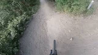
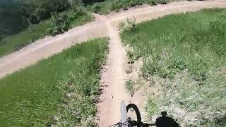
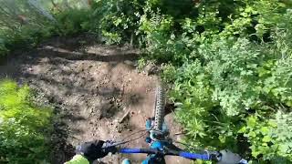
This downhill bike trail cuts connects Jennis to CMG cutting out an uphill section on Jenni's. Starting just under the Payday chairlift at a switchback mid-way down Jenni's Trail, Loose Moose heads downhill at a mellow grade ensured by the numerous switchbacks. End up at another random switchback on the lower part of CMG (this part of CMG is for downhill biking only) and watch for non-bikers making their way uphill. You'll cross a couple of ski runs, but mostly be riding through aspen woodlands next to the alpine coaster. There are lots of berms, but watch out for ones that are blown out. This trail and CMG do not get much maintenance anymore.

Adaptive Bike Info
aMTB Blue Rating: Intermediate features and steeper terrain.

4’ wide. this trail update is part of the bigger picture of having a top to bottom (Crescent Lift) adaptive friendly trail which this trail system has needed for a while.

Local Trail Association
Traditionally Indigenous Territory

Recent Activity on Trail

Past Week
  • 26 rides
  • 14 miles average
6 Months
  • 198 rides
  • 12 miles avg distance
All
  • 2,103 rides
  • Last: Jun 30, 2026
c1c2c3c4
January
February
March
April
May
June
July
August
September
October
November
December
update trails status or condition

Loose Moose Trail Reports

Status:
on Jun 22, 2026
Very Dry
Avg: 3.95 (19 votes)
Your vote: 0

view (10,130)
close
3D
Trail Conditions
  • Unknown
  • Snow Groomed
  • Snow Packed
  • Snow Covered
  • Snow Cover Partial
  • Freeze/thaw Cycle
  • Icy
  • Prevalent Mud
  • Wet
  • Variable
  • Ideal
  • Dry
  • Very Dry
Trail Flow (Ridden Direction)
Trailforks scans users ridelogs to determine the most popular direction each trail is ridden. A good flowing trail network will have most trails flowing in a single direction according to their intension.
The colour categories are based on what percentage of riders are riding a trail in its intended direction.
  • > 96%
  • > 90%
  • > 80%
  • > 70%
  • > 50%
  • < 50%
  • bi-directional trail
  • no data
Trail Last Ridden
Trailforks scans ridelogs to determine the last time a trail was ridden.
  • < 2 days
  • < 1 week
  • < 2 weeks
  • < 1 month
  • < 6 months
  • > 6 months
Trail Ridden Direction
The intended direction a trail should be ridden.
  • Downhill Only
  • Downhill Primary
  • Both Directions
  • Uphill Primary
  • Uphill Only
  • One Direction
Contribute Details
Colors indicate trail is missing specified detail.
  • Description
  • Photos
  • Description & Photos
  • Videos
Trail Popularity ?
Trailforks scans ridelogs to determine which trails are ridden the most in the last 9 months. Trails are compared with nearby trails in the same city region with a possible 25 colour shades. Think of this as a heatmap, more rides = more kinetic energy = warmer colors.
  • most popular
  • popular
  • less popular
  • not popular
ATV/ORV/OHV Filter
Max Vehicle Width
inches
US Cell Coverage
Legend
cell carrier legend

Radar Time
Activity Recordings
Trailforks uses anonymized public activity data. ?
Activity Recordings
Trailforks uses anonymized public activity data. ?
Personal Heatmap
Activity Types
all / none
Options
2
Date range month
Winter Trails
Warning A routing network for winter maps does not exist. Selecting trails using the winter trails layer has been disabled.
Missing Trails
Most Popular
Least Popular
Trails are colored based on popularity. The more popular a trail is, the more red. Less popular trails trend towards green.
Jump Magnitude Heatmap
Heatmap of where riders jump on trails. Zoom in to see individual jumps, click circles to view jump details.
BC Backroad Status

Service Road Atlas is a free to use, community-driven service for viewing and creating reports on the numerous back-country service roads around B.C. and Alberta.

map legend
Slope Aspect
Direction the slope faces
Flat N NE E SE S SW W NW
Trails Deemphasized
Trails are shown in grey.
disable
Only show trails with no bike usage.
Enable
Suggested Layers
Based on selected activity type

    Save the current map location and zoom level as your default home location whenever this page is loaded.

    Save
        Directions to loose-moose trailhead (40.642710, -111.507830)

        Photos

        3 more »
        73 |
        Jun 23, 2022 @ 9:13am
        Jun 23, 2022
        67 |
        Jun 23, 2022 @ 9:13am
        Jun 23, 2022
        116 |
        Jul 30, 2021 @ 8:23am
        Jul 30, 2021

        Videos

        4 more »
        Loose Moose: 00:00-1:04
        2:01 | 306 | Jul 18, 2022 , Park City
        6/25/22 Loose Moose
        4:36 | 314 | Jun 27, 2022 , Park City
        6/14/22 Jenni’s to Loose Moose
        0:59 | 282 | Jun 15, 2022 , Park City
        loose moose 7-29-21
        0:21 | 40 | Jul 30, 2021 , Park City

        Routes with this trail

        4.0 7 miles 286 ft 5 Shuttled
        Fun trails in park city/deer valley. Probably a shuttle route.
        5 miles 861 ft 3
        Jenni’s lower, Jenni’s upper to , down and then return
        23 miles 3,588 ft 11
        Base to 9k and back to base

        4 Reviews & Comments


        We hope you've been enjoying Trailforks!

        Create a FREE account to view trail comments and much more.

        • By toddTF Pro Trailforks & contributors
        • #11693 - 4,705 views

        Frequently Asked Questions About Loose Moose

        Where is Loose Moose located?
        Loose Moose is located in Park City Mountain Resort, Park City, Utah, United States. It is part of the Park City Mountain Resort trail network. The trailhead is located at coordinates 40.64271, -111.50783.
        How hard is Loose Moose?
        Loose Moose is rated as Blue difficulty. The average grade is 6.2%.
        What is the elevation gain for Loose Moose?
        The trail has 91 m of elevation descent. The elevation ranges from 2,215 m to 2,306 m.
        Is Loose Moose a point to point trail?
        Yes, Loose Moose is a point to point trail. The direction is Downhill Only. The trail type is singletrack.

        Hit the Trail

        Open in App

        Get this trail on your phone instantly.
        open trail in app

        Download Trail

        Save to wishlist, Garmin & download.
        save the trail

        Find Related Routes

        Find routes and users activities that include this trail.
        find routes for this trail

        You must enter a description before submitting.