more stats
9.2 miles
Distance
841 ft
Climb
-841 ft
Descent
01:06:04
Avg time
-1 ft
Altitude change
160 ft
Altitude min
393 ft
Altitude max
246 ft
Altitude start
246 ft
Altitude end
-23.2%
Grade max
27.1%
Grade min
3 miles
Distance climb
3 miles
Distance down
3 miles
Distance flat
01:06:04
Avg time

Los Pinchos Details

  • Activities
    • Mountain Bike
    • E-Bike
    • Hike
    • Trail Running
  • Riding Area
  • Difficulty Rating
  • Local Popularity
    70 in Mountain Biking [+]
    • 55 in E-Biking
    • 5 in Trail Running
    • 5 in Hiking
  • Global Ranking
    #39859 in Mountain Biking [+]
    • #56190 in E-Biking
    • #128382 in Trail Running
    • #121467 in Hiking
  • Trail Type
    Singletrack
  • Bike Type
    AM, XC
  • Direction
    Both Directions
    Popular In Reverse
  • Climb Difficulty
    Blue
  • Physical Rating
    Moderate
  • Trail Visibility
    Always easy to follow
  • Season
    Jan - Dec
  • Dogs Allowed
    Yes
  • eBike Allowed
    Yes up to Class 1
  • TTFs on Trail
    Bridge, Rock Garden

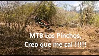
The trail is well-maintained and marked with signs and arrows. This is a dry area with very little rainfall. You'll be riding below tree shadows about 30% of the time. It's a scenic route with moderate ascents and descents.

The trail's surface is predominantly dusty hard-park with some loose rocks. You'll find some cactus thorns so carry spare tubes if necessary.

Access Info

Right on front of "La Casa de Los Pinchos" there's a gate to enter the trail.

Traditionally Indigenous Territory

Recent Activity on Trail

Past Week
  • 0 rides
  •  
6 Months
  • 8 rides
  • 14 miles avg distance
All
  • 188 rides
  • Last: Jun 19, 2026
c1c2c3c4
January
February
March
April
May
June
July
August
September
October
November
December
Status:
on May 30, 2024
Ideal
Avg: 4.24 (6 votes)
Your vote: 0

view (4,207)
close
3D
Trail Conditions
  • Unknown
  • Snow Groomed
  • Snow Packed
  • Snow Covered
  • Snow Cover Partial
  • Freeze/thaw Cycle
  • Icy
  • Prevalent Mud
  • Wet
  • Variable
  • Ideal
  • Dry
  • Very Dry
Trail Flow (Ridden Direction)
Trailforks scans users ridelogs to determine the most popular direction each trail is ridden. A good flowing trail network will have most trails flowing in a single direction according to their intension.
The colour categories are based on what percentage of riders are riding a trail in its intended direction.
  • > 96%
  • > 90%
  • > 80%
  • > 70%
  • > 50%
  • < 50%
  • bi-directional trail
  • no data
Trail Last Ridden
Trailforks scans ridelogs to determine the last time a trail was ridden.
  • < 2 days
  • < 1 week
  • < 2 weeks
  • < 1 month
  • < 6 months
  • > 6 months
Trail Ridden Direction
The intended direction a trail should be ridden.
  • Downhill Only
  • Downhill Primary
  • Both Directions
  • Uphill Primary
  • Uphill Only
  • One Direction
Contribute Details
Colors indicate trail is missing specified detail.
  • Description
  • Photos
  • Description & Photos
  • Videos
Trail Popularity ?
Trailforks scans ridelogs to determine which trails are ridden the most in the last 9 months. Trails are compared with nearby trails in the same city region with a possible 25 colour shades. Think of this as a heatmap, more rides = more kinetic energy = warmer colors.
  • most popular
  • popular
  • less popular
  • not popular
ATV/ORV/OHV Filter
Max Vehicle Width
inches
US Cell Coverage
Legend
cell carrier legend

Radar Time
Activity Recordings
Trailforks uses anonymized public activity data. ?
Activity Recordings
Trailforks uses anonymized public activity data. ?
Personal Heatmap
Activity Types
all / none
Options
2
Date range month
Winter Trails
Warning A routing network for winter maps does not exist. Selecting trails using the winter trails layer has been disabled.
Missing Trails
Most Popular
Least Popular
Trails are colored based on popularity. The more popular a trail is, the more red. Less popular trails trend towards green.
Jump Magnitude Heatmap
Heatmap of where riders jump on trails. Zoom in to see individual jumps, click circles to view jump details.
BC Backroad Status

Service Road Atlas is a free to use, community-driven service for viewing and creating reports on the numerous back-country service roads around B.C. and Alberta.

map legend
Slope Aspect
Direction the slope faces
Flat N NE E SE S SW W NW
Trails Deemphasized
Trails are shown in grey.
disable
Only show trails with no bike usage.
Enable
Suggested Layers
Based on selected activity type

    Save the current map location and zoom level as your default home location whenever this page is loaded.

    Save
        Directions to los-pinchos trailhead (18.035010, -66.240730)

        Photos

        59 more »
        85 |
        Jul 24, 2022 @ 6:52am
        Jul 24, 2022
        86 |
        Jul 24, 2022 @ 6:52am
        Jul 24, 2022
        61 |
        Jul 24, 2022 @ 6:52am
        Jul 24, 2022
        78 |
        Jul 24, 2022 @ 6:52am
        Jul 24, 2022

        Videos

        4 more »
        Los Pinchos MTB 'La ruta que nunca defrauda'
        9:51 | 312 | Jun 2, 2023 , Salinas
        Los Pinchos MTB, te caiste?
        14:23 | 222 | Mar 29, 2022 , Salinas
        #mtblospinchos
        5:35 | 466 | Jun 4, 2020 , Salinas
        Los Pinchos, Salinas, PR - MTB PR Trails 2017
        8:58 | 702 | Dec 7, 2018 , Salinas

        3 Reviews & Comments


        We hope you've been enjoying Trailforks!

        Create a FREE account to view trail comments and much more.

        • By rampagusTF Pro Monagas & contributors
        • #34091 - 6,165 views

        Frequently Asked Questions About Los Pinchos

        Where is Los Pinchos located?
        Los Pinchos is located in Los Pinchos Trail Network, Salinas, Puerto Rico. It is part of the Los Pinchos Trail Network trail network. The trailhead is located at coordinates 18.03501, -66.24073.
        How hard is Los Pinchos?
        Los Pinchos is rated as Blue difficulty. The physical rating is Moderate. The climb difficulty is rated Blue.
        What is the elevation gain for Los Pinchos?
        Los Pinchos has 841 ft of elevation gain. The trail has 841 ft of elevation descent. The elevation ranges from 160 ft to 393 ft.
        Is Los Pinchos a point to point trail?
        Los Pinchos is not a point to point trail. The direction is Both Directions. The trail type is singletrack.

        Hit the Trail

        Open in App

        Get this trail on your phone instantly.
        open trail in app

        Download Trail

        Save to wishlist, Garmin & download.
        save the trail

        Find Related Routes

        Find routes and users activities that include this trail.
        find routes for this trail

        You must enter a description before submitting.