more stats
2.2 miles
Distance
61 ft
Climb
-646 ft
Descent
00:22:47
Avg time
-587 ft
Altitude change
5,488 ft
Altitude min
6,132 ft
Altitude max
6,075 ft
Altitude start
5,489 ft
Altitude end
-5%
Grade
-28.9%
Grade max
14.3%
Grade min
1,978 ft
Distance climb
2 miles
Distance down
522 ft
Distance flat
00:22:47
Avg time

Lower Bitterbrush Details

  • Activities
    • Mountain Bike
    • Hike
    • Trail Running
  • Riding Area
    Hall Ranch
    Lyons, Colorado
  • Difficulty Rating
  • Voted Difficulty
    Black Diamond (5 votes)
  • Local Popularity
    90 in Mountain Biking [+]
    • 80 in Trail Running
    • 70 in Hiking
  • Global Ranking
    #13984 in Mountain Biking [+]
    • #2108 in Trail Running
    • #72272 in Hiking
  • Hiking SAC Scale
    T1 Hiking
  • Trail Type
    Singletrack
  • Bike Type
    AM
  • Direction
    Both Directions
    Popular Direction Shown
  • Climb Difficulty
    Black Diamond
  • Physical Rating
    Hard
  • Trail Visibility
    Sometimes hard to follow
  • eBike Allowed
  • TTFs on Trail
    Rock Face, Rock Garden
  • Land Owner

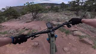
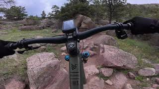
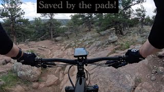
Very deserving of its black diamond rating. Lower Bitterbrush reminds me of desert riding in southern Utah, almost like a steeper version of UPS/LPS in Moab. Suffice it to say, there are many technical rock features, interspersed with brief patches of singletrack to catch your breath. Many of the rock features have multiple lines, so get creative

Local Trail Association

Recent Activity on Trail

Past Week
  • 3 rides
  • 12 miles average
6 Months
  • 162 rides
  • 13 miles avg distance
All
  • 917 rides
  • Last: Jun 17, 2026
c1c2c3c4
January
February
March
April
May
June
July
August
September
October
November
December
update trails status or condition

Lower Bitterbrush Trail Reports

statusdatedescription
Jun 10, 2026 @ 6:03pm (America/Denver)
Jun 10, 2026
May 22, 2026 @ 5:12pm (America/Denver)
May 22, 2026
Trail is open. Please update conditions if you ride
May 19, 2026 @ 1:25pm (America/Denver)
May 19, 2026
Trails closed for muddy conditions. Status will be update when trail reopens.
May 8, 2026 @ 1:18pm (America/Denver)
May 8, 2026
Trail is open. Please update conditions if you ride.
May 5, 2026 @ 11:31am (America/Denver)
May 5, 2026
Closed for muddy conditions. Status will be updated when trail reopens
more »
Status:
on Jun 10, 2026
Dry
Avg: 4.37 (37 votes)
Your vote: 0

view (9,880)
close
3D
Trail Conditions
  • Unknown
  • Snow Groomed
  • Snow Packed
  • Snow Covered
  • Snow Cover Partial
  • Freeze/thaw Cycle
  • Icy
  • Prevalent Mud
  • Wet
  • Variable
  • Ideal
  • Dry
  • Very Dry
Trail Flow (Ridden Direction)
Trailforks scans users ridelogs to determine the most popular direction each trail is ridden. A good flowing trail network will have most trails flowing in a single direction according to their intension.
The colour categories are based on what percentage of riders are riding a trail in its intended direction.
  • > 96%
  • > 90%
  • > 80%
  • > 70%
  • > 50%
  • < 50%
  • bi-directional trail
  • no data
Trail Last Ridden
Trailforks scans ridelogs to determine the last time a trail was ridden.
  • < 2 days
  • < 1 week
  • < 2 weeks
  • < 1 month
  • < 6 months
  • > 6 months
Trail Ridden Direction
The intended direction a trail should be ridden.
  • Downhill Only
  • Downhill Primary
  • Both Directions
  • Uphill Primary
  • Uphill Only
  • One Direction
Contribute Details
Colors indicate trail is missing specified detail.
  • Description
  • Photos
  • Description & Photos
  • Videos
Trail Popularity ?
Trailforks scans ridelogs to determine which trails are ridden the most in the last 9 months. Trails are compared with nearby trails in the same city region with a possible 25 colour shades. Think of this as a heatmap, more rides = more kinetic energy = warmer colors.
  • most popular
  • popular
  • less popular
  • not popular
ATV/ORV/OHV Filter
Max Vehicle Width
inches
US Cell Coverage
Legend
cell carrier legend

Radar Time
Activity Recordings
Trailforks uses anonymized public activity data. ?
Activity Recordings
Trailforks uses anonymized public activity data. ?
Personal Heatmap
Activity Types
all / none
Options
2
Date range month
Winter Trails
Warning A routing network for winter maps does not exist. Selecting trails using the winter trails layer has been disabled.
Missing Trails
Most Popular
Least Popular
Trails are colored based on popularity. The more popular a trail is, the more red. Less popular trails trend towards green.
Jump Magnitude Heatmap
Heatmap of where riders jump on trails. Zoom in to see individual jumps, click circles to view jump details.
BC Backroad Status

Service Road Atlas is a free to use, community-driven service for viewing and creating reports on the numerous back-country service roads around B.C. and Alberta.

map legend
Slope Aspect
Direction the slope faces
Flat N NE E SE S SW W NW
Trails Deemphasized
Trails are shown in grey.
disable
Only show trails with no bike usage.
Enable
Suggested Layers
Based on selected activity type

    Save the current map location and zoom level as your default home location whenever this page is loaded.

    Save
        Directions to lower-bitterbrush trailhead (40.220360, -105.305940)

        Photos

        42 more »
        1,038 |
        Dec 24, 2014 @ 8:58am
        Dec 24, 2014
        288 |
        Oct 5, 2022 @ 4:13pm
        Oct 5, 2022
        411 |
        Oct 5, 2022 @ 4:13pm
        Oct 5, 2022
        604 |
        Feb 19, 2021 @ 2:57pm
        Feb 19, 2021

        Videos

        13 more »
        youtuber Trail Boss:  Mountain Biking Bitterbrush Trail...
        3:53 | 1060 | Apr 16, 2018 , Lyons
        Lower Bitterbrush - Highlights
        4:54 | 179 | May 14, 2025 , Lyons
        Lower Bitterbrush
        12:33 | 75 | May 13, 2025 , Lyons
        Ouch! - fatty vs black tech - Lower...
        13:46 | 200 | May 6, 2024 , Lyons

        Routes with this trail

        5.0 10 miles 1,594 ft 6 Out & Back
        Tackling Hall Ranch up aka "The Rock Garden" bumps this intermediate/advanced area into solid double...
        3.8 12 miles 1,670 ft 5 Loop
        By far the best way to ride Hall Ranch. This ride is best started by parking in the town of Lyons either...
        4.0 14 miles 1,860 ft 7 Loop
        This is a great way to ride Hall Ranch leaving from right in Lyons. No parking hassles. No gnarly...

        9 Reviews & Comments


        We hope you've been enjoying Trailforks!

        Create a FREE account to view trail comments and much more.

        • By toddTF Pro Trailforks & contributors
        • #13702 - 10,671 views

        Frequently Asked Questions About Lower Bitterbrush

        Where is Lower Bitterbrush located?
        Lower Bitterbrush is located in Hall Ranch, Lyons, Colorado, United States. It is part of the Hall Ranch trail network. The trailhead is located at coordinates 40.22036, -105.30594.
        How hard is Lower Bitterbrush?
        Lower Bitterbrush is rated as Black Diamond difficulty. The physical rating is Hard. The average grade is 5%. The climb difficulty is rated Black Diamond.
        What is the elevation gain for Lower Bitterbrush?
        Lower Bitterbrush has 61 ft of elevation gain. The trail has 646 ft of elevation descent. The elevation ranges from 5,488 ft to 6,132 ft.
        Is Lower Bitterbrush a point to point trail?
        Lower Bitterbrush is not a point to point trail. The direction is Both Directions. The trail type is singletrack.

        Hit the Trail

        Open in App

        Get this trail on your phone instantly.
        open trail in app

        Download Trail

        Save to wishlist, Garmin & download.
        save the trail

        Find Related Routes

        Find routes and users activities that include this trail.
        find routes for this trail

        You must enter a description before submitting.