more stats
1,522 ft
Distance
-156 ft
Descent
00:01:44
Avg time
-156 ft
Altitude change
1,133 ft
Altitude min
1,290 ft
Altitude max
1,290 ft
Altitude start
1,132 ft
Altitude end
-10.3%
Grade
-20.4%
Grade max
-2.4%
Grade min
1,440 ft
Distance down
79 ft
Distance flat
00:01:44
Avg time

Lower Expresso Details

  • Activities
    • Mountain Bike
    • E-Bike
    • Trail Running
  • Riding Area
    Mount Fromme
    North Vancouver, British Columbia
  • Difficulty Rating
  • Voted Difficulty
    Blue (9 votes)
  • Local Popularity
    100 in Mountain Biking [+]
    • 100 in E-Biking
    • 75 in Trail Running
  • Global Ranking
    #83 in Mountain Biking [+]
    • #1815 in E-Biking
    • #36582 in Trail Running
  • Trail Type
    Singletrack
  • Bike Type
    DH, AM, XC
  • Trail Visibility
    Always easy to follow
  • Dogs Allowed
    Yes
  • eBike Allowed
  • TTFs on Trail
    A-Frame, Berm, Bridge, Jump, Gap Jump, Ladder Bridge, Rock Garden
  • Year Opened
    2017
  • Land Owner
    DNV

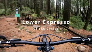
Built with a true community effort, led by the Race Face Shore Corps to connect Expresso with Pennzoil to create one continuous descent, the trail has high speed sections, pumps & rollers and even a couple of A Frame/launchers and table tops to keep things interesting. Everything is rollable so there's no consequences for the intermediate rider. Hit the rock roll near the exit for a happy ending. Thanks to all of the community supporters and volunteers who put their skin in the game including Sacre-Davey Engineering, Steed Cycles, Santa Cruz Bicycles, Arc'teryx & Methanex. Thank you to the District of North Vancouver for the permission and support to build the trail.

Trail Supporters
Local Trail Association

Recent Activity on Trail

Past Week
  • 99 rides
  • 10 miles average
6 Months
  • 1,559 rides
  • 8 miles avg distance
All
  • 15,472 rides
  • Last: Jun 21, 2026
c1c2c3c4
January
February
March
April
May
June
July
August
September
October
November
December
Status:
on Jun 18, 2026
Very Dry
Avg: 4.7 (89 votes)
Your vote: 0

view (93,644)
close
3D
Trail Conditions
  • Unknown
  • Snow Groomed
  • Snow Packed
  • Snow Covered
  • Snow Cover Partial
  • Freeze/thaw Cycle
  • Icy
  • Prevalent Mud
  • Wet
  • Variable
  • Ideal
  • Dry
  • Very Dry
Trail Flow (Ridden Direction)
Trailforks scans users ridelogs to determine the most popular direction each trail is ridden. A good flowing trail network will have most trails flowing in a single direction according to their intension.
The colour categories are based on what percentage of riders are riding a trail in its intended direction.
  • > 96%
  • > 90%
  • > 80%
  • > 70%
  • > 50%
  • < 50%
  • bi-directional trail
  • no data
Trail Last Ridden
Trailforks scans ridelogs to determine the last time a trail was ridden.
  • < 2 days
  • < 1 week
  • < 2 weeks
  • < 1 month
  • < 6 months
  • > 6 months
Trail Ridden Direction
The intended direction a trail should be ridden.
  • Downhill Only
  • Downhill Primary
  • Both Directions
  • Uphill Primary
  • Uphill Only
  • One Direction
Contribute Details
Colors indicate trail is missing specified detail.
  • Description
  • Photos
  • Description & Photos
  • Videos
Trail Popularity ?
Trailforks scans ridelogs to determine which trails are ridden the most in the last 9 months. Trails are compared with nearby trails in the same city region with a possible 25 colour shades. Think of this as a heatmap, more rides = more kinetic energy = warmer colors.
  • most popular
  • popular
  • less popular
  • not popular
ATV/ORV/OHV Filter
Max Vehicle Width
inches
US Cell Coverage
Legend
cell carrier legend

Radar Time
Activity Recordings
Trailforks uses anonymized public activity data. ?
Activity Recordings
Trailforks uses anonymized public activity data. ?
Personal Heatmap
Activity Types
all / none
Options
2
Date range month
Winter Trails
Warning A routing network for winter maps does not exist. Selecting trails using the winter trails layer has been disabled.
Missing Trails
Most Popular
Least Popular
Trails are colored based on popularity. The more popular a trail is, the more red. Less popular trails trend towards green.
Jump Magnitude Heatmap
Heatmap of where riders jump on trails. Zoom in to see individual jumps, click circles to view jump details.
BC Backroad Status

Service Road Atlas is a free to use, community-driven service for viewing and creating reports on the numerous back-country service roads around B.C. and Alberta.

map legend
Slope Aspect
Direction the slope faces
Flat N NE E SE S SW W NW
Trails Deemphasized
Trails are shown in grey.
disable
Only show trails with no bike usage.
Enable
Suggested Layers
Based on selected activity type

    Save the current map location and zoom level as your default home location whenever this page is loaded.

    Save
        Directions to lower-expresso trailhead (49.350060, -123.052510)

        Photos

        42 more »
        390 |
        Sep 9, 2018 @ 5:09pm
        Sep 9, 2018
        472 |
        Feb 11, 2018 @ 11:03pm
        Feb 11, 2018
        40 |
        May 13, 2026 @ 11:31am
        May 13, 2026
        73 |
        Apr 30, 2024 @ 10:39pm
        Apr 30, 2024

        Videos

        40 more »
        youtuber HOT LAP 6: Orbea Rise: DIGGER: North Shore MTB
        4:14 | 565 | May 20, 2022 , North Vancouver
        youtuber Lower Expresso to Pennzoil | Mount Fromme,...
        2:30 | 1994 | Jun 2, 2018 , North Vancouver
        youtuber LOWER EXPRESSO: North Shore: Trail Review
        4:02 | 490 | Jun 19, 2021 , North Vancouver
        Lower Expresso | North Vancouver's BEST Blue...
        0:15 | 53 | Nov 29, 2025 , North Vancouver

        Routes with this trail

        5.0 3 miles 975 ft 5
        Fromme Quickie West Side Flow North Shore Relive Your Ride For other ride suggestions for this and other...
        5.0 61 miles 9,228 ft 77 Loop
        NOW REPLACED WITH A BETTER VERSION AFTER A TEST RIDE...
        5.0 3 miles 800 ft 8 Loop
        Great introductory route for this area. Climbing - Moderate difficulty, great introductory single track...

        Trail Events

        4 Reviews & Comments


        We hope you've been enjoying Trailforks!

        Create a FREE account to view trail comments and much more.

        • By WoodroTF Pro & contributors
        • #62441 - 18,329 views

        Frequently Asked Questions About Lower Expresso

        Where is Lower Expresso located?
        Lower Expresso is located in Mount Fromme, North Vancouver, British Columbia, Canada. It is part of the Mount Fromme trail network. The trailhead is located at coordinates 49.35006, -123.05251.
        How hard is Lower Expresso?
        Lower Expresso is rated as Blue difficulty. The average grade is 10.3%.
        What is the elevation gain for Lower Expresso?
        The trail has 156 ft of elevation descent. The elevation ranges from 1,133 ft to 1,290 ft.
        How long is Lower Expresso?
        Lower Expresso is 1,522 ft long. The trail type is singletrack.

        Hit the Trail

        Open in App

        Get this trail on your phone instantly.
        open trail in app

        Download Trail

        Save to wishlist, Garmin & download.
        save the trail

        Find Related Routes

        Find routes and users activities that include this trail.
        find routes for this trail

        You must enter a description before submitting.