more stats
2.0 miles
Distance
220 ft
Climb
-822 ft
Descent
00:33:20
Avg time
-602 ft
Altitude change
497 ft
Altitude min
1,112 ft
Altitude max
1,112 ft
Altitude start
509 ft
Altitude end
-5.6%
Grade
-65.5%
Grade max
35.9%
Grade min
2,812 ft
Distance climb
1 mile
Distance down
1,145 ft
Distance flat
00:33:20
Avg time

Lower Maple Syrup Details

  • Activities
    • Mountain Bike
    • E-Bike
  • Riding Area
    Maple Mountain
    Duncan, British Columbia
  • Difficulty Rating
  • Voted Difficulty
    Black Diamond (3 votes)
  • Local Popularity
    75 in Mountain Biking [+]
    • 80 in E-Biking
  • Global Ranking
    #17397 in Mountain Biking [+]
    • #2922 in E-Biking
  • Trail Type
    Singletrack
  • Bike Type
    AM
  • Direction
    Downhill Only
    Popular Direction Shown
  • Climb Difficulty
    Black Diamond
  • Physical Rating
    Hard
  • Trail Visibility
    Always easy to follow
  • Dogs Allowed
    Yes
  • eBike Allowed
  • TTFs on Trail
    Berm, Bridge, Drop, Jump, Rock Face, Rock Garden
  • Land Owner
    Municipality of North Cowichan

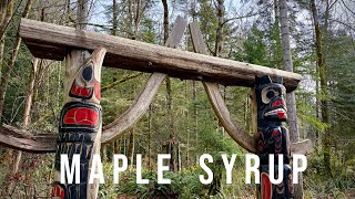
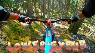
The lower half of the full Maple Mountain descent of Maple Syrup is a stunning trail with beautiful rocky bluffs and beautiful creek crossings. This portion of the trail requires some strong pedalling still for those that have just come from Upper Maple. Using the Story Trail Connector is a great way to enjoy this trail if you aren't looking to pedal all the way to the summit.

Local Trail Association

Recent Activity on Trail

Past Week
  • 0 rides
  •  
6 Months
  • 73 rides
  • 12 miles avg distance
All
  • 693 rides
  • Last: Jun 20, 2026
c1c2c3c4
January
February
March
April
May
June
July
August
September
October
November
December
update trails status or condition

Lower Maple Syrup Trail Reports

statusdatedescription
Jun 11, 2026 @ 12:58pm (America/Vancouver)
Jun 11, 2026
reporter Thank-you recent rain for great conditions
May 10, 2026 @ 11:42am (America/Vancouver)
May 10, 2026
reporter Exceptionally awesome conditions this ride
Apr 18, 2025 @ 10:57am
Apr 18, 2025
reporter
Apr 12, 2025 @ 11:12am
Apr 12, 2025
All clear and running great
Nov 23, 2024 @ 8:48pm
Nov 23, 2024
Minor derbis on the trail after the storm, but no significant damage or fallen trees
more »
Status:
on Jun 11, 2026
Ideal
Avg: 4.17 (54 votes)
Your vote: 0

view (3,477)
close
3D
Trail Conditions
  • Unknown
  • Snow Groomed
  • Snow Packed
  • Snow Covered
  • Snow Cover Partial
  • Freeze/thaw Cycle
  • Icy
  • Prevalent Mud
  • Wet
  • Variable
  • Ideal
  • Dry
  • Very Dry
Trail Flow (Ridden Direction)
Trailforks scans users ridelogs to determine the most popular direction each trail is ridden. A good flowing trail network will have most trails flowing in a single direction according to their intension.
The colour categories are based on what percentage of riders are riding a trail in its intended direction.
  • > 96%
  • > 90%
  • > 80%
  • > 70%
  • > 50%
  • < 50%
  • bi-directional trail
  • no data
Trail Last Ridden
Trailforks scans ridelogs to determine the last time a trail was ridden.
  • < 2 days
  • < 1 week
  • < 2 weeks
  • < 1 month
  • < 6 months
  • > 6 months
Trail Ridden Direction
The intended direction a trail should be ridden.
  • Downhill Only
  • Downhill Primary
  • Both Directions
  • Uphill Primary
  • Uphill Only
  • One Direction
Contribute Details
Colors indicate trail is missing specified detail.
  • Description
  • Photos
  • Description & Photos
  • Videos
Trail Popularity ?
Trailforks scans ridelogs to determine which trails are ridden the most in the last 9 months. Trails are compared with nearby trails in the same city region with a possible 25 colour shades. Think of this as a heatmap, more rides = more kinetic energy = warmer colors.
  • most popular
  • popular
  • less popular
  • not popular
ATV/ORV/OHV Filter
Max Vehicle Width
inches
US Cell Coverage
Legend
cell carrier legend

Radar Time
Activity Recordings
Trailforks uses anonymized public activity data. ?
Activity Recordings
Trailforks uses anonymized public activity data. ?
Personal Heatmap
Activity Types
all / none
Options
2
Date range month
Winter Trails
Warning A routing network for winter maps does not exist. Selecting trails using the winter trails layer has been disabled.
Missing Trails
Most Popular
Least Popular
Trails are colored based on popularity. The more popular a trail is, the more red. Less popular trails trend towards green.
Jump Magnitude Heatmap
Heatmap of where riders jump on trails. Zoom in to see individual jumps, click circles to view jump details.
BC Backroad Status

Service Road Atlas is a free to use, community-driven service for viewing and creating reports on the numerous back-country service roads around B.C. and Alberta.

map legend
Slope Aspect
Direction the slope faces
Flat N NE E SE S SW W NW
Trails Deemphasized
Trails are shown in grey.
disable
Only show trails with no bike usage.
Enable
Suggested Layers
Based on selected activity type

    Save the current map location and zoom level as your default home location whenever this page is loaded.

    Save
        Directions to lower-maple-syrup trailhead (48.831973, -123.617241)

        Photos

        95 more »
        961 |
        Feb 22, 2016 @ 10:59pm
        Feb 22, 2016
        3,118 |
        Oct 28, 2013 @ 9:31am
        Oct 28, 2013
        1,478 |
        Feb 22, 2016 @ 5:11am
        Feb 22, 2016
        41 |
        Jun 16, 2024 @ 10:42am
        Jun 16, 2024

        Videos

        37 more »
        youtuber Maple Syrup - Full Trail - Vancouver Island...
        25:04 | 80 | Jan 28, 2026 , Duncan
        A Swiss biker in BC EP 33 II Lower Maple Syrup...
        9:41 | 82 | Sep 14, 2025 , Duncan
        Lower Maple Syrup
        15:38 | 161 | Sep 22, 2024 , Duncan
        Maple Mountain -   Maple Syrup & Phloem
        3:16 | 452 | Jul 24, 2022 , Duncan

        Routes with this trail

        4.5 9 miles 1,812 ft 11 Loop
        This is an excellent loop, that has a bit of everything. Starting off with some of the best climbing...
        3.5 16 miles 3,021 ft 13
        Maple Mountain Full Maple
        17 miles 3,309 ft 14
        BCBR Rolling Thunder Presented by Transition The Long Course (A) is 27 km 1009 m elev., the Short Course...

        16 Reviews & Comments


        We hope you've been enjoying Trailforks!

        Create a FREE account to view trail comments and much more.

        • By canadakaTF Pro Trailforks & contributors
        • #3276 - 16,632 views

        Frequently Asked Questions About Lower Maple Syrup

        Where is Lower Maple Syrup located?
        Lower Maple Syrup is located in Maple Mountain, Duncan, British Columbia, Canada. It is part of the Maple Mountain trail network. The trailhead is located at coordinates 48.83197, -123.61724.
        How hard is Lower Maple Syrup?
        Lower Maple Syrup is rated as Black Diamond difficulty. The physical rating is Hard. The average grade is 5.6%. The climb difficulty is rated Black Diamond.
        What is the elevation gain for Lower Maple Syrup?
        Lower Maple Syrup has 67 m of elevation gain. The trail has 251 m of elevation descent. The elevation ranges from 152 m to 339 m.
        Is Lower Maple Syrup a point to point trail?
        Yes, Lower Maple Syrup is a point to point trail. The direction is Downhill Only. The trail type is singletrack.

        Hit the Trail

        Open in App

        Get this trail on your phone instantly.
        open trail in app

        Download Trail

        Save to wishlist, Garmin & download.
        save the trail

        Find Related Routes

        Find routes and users activities that include this trail.
        find routes for this trail

        You must enter a description before submitting.