more stats
2,625 ft
Distance
-306 ft
Descent
00:05:30
Avg time
-308 ft
Altitude change
877 ft
Altitude min
1,185 ft
Altitude max
1,185 ft
Altitude start
876 ft
Altitude end
-11.7%
Grade
-34.3%
Grade max
-1.8%
Grade min
2,608 ft
Distance down
20 ft
Distance flat
00:05:30
Avg time

Lower NE Style Details

  • Activities
    • Mountain Bike
  • Riding Area
    Highland Mountain Bike Park
    Northfield, New Hampshire
  • Difficulty Rating
  • Local Popularity
    60 in Mountain Biking
  • Trail Type
    Singletrack
  • Bike Type
    DH, AM, DJ
  • Direction
    Both Directions
    Popular Direction Shown
  • Physical Rating
    Hard
  • Trail Visibility
    Always easy to follow
  • eBike Allowed
  • TTFs on Trail
    Berm, Bridge, Drop, Jump

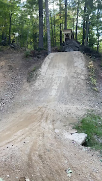
A very popular slope style trail, it starts with a big, wooden bridge that propels the rider into a fun series of berms and jumps. The trail finishes with a great drop into a big berm and a final jump before depositing the rider at the lift.

Bike Park

Traditionally Indigenous Territory

Recent Activity on Trail

Past Week
  • 4 rides
  • 26 miles average
6 Months
  • 11 rides
  • 21 miles avg distance
All
  • 474 rides
  • Last: Jun 12, 2026
c1c2c3c4
January
February
March
April
May
June
July
August
September
October
November
December
Status:
on Jul 13, 2025
Very Dry
Avg: 4.35 (5 votes)
Your vote: 0

view (5,627)
close
3D
Trail Conditions
  • Unknown
  • Snow Groomed
  • Snow Packed
  • Snow Covered
  • Snow Cover Partial
  • Freeze/thaw Cycle
  • Icy
  • Prevalent Mud
  • Wet
  • Variable
  • Ideal
  • Dry
  • Very Dry
Trail Flow (Ridden Direction)
Trailforks scans users ridelogs to determine the most popular direction each trail is ridden. A good flowing trail network will have most trails flowing in a single direction according to their intension.
The colour categories are based on what percentage of riders are riding a trail in its intended direction.
  • > 96%
  • > 90%
  • > 80%
  • > 70%
  • > 50%
  • < 50%
  • bi-directional trail
  • no data
Trail Last Ridden
Trailforks scans ridelogs to determine the last time a trail was ridden.
  • < 2 days
  • < 1 week
  • < 2 weeks
  • < 1 month
  • < 6 months
  • > 6 months
Trail Ridden Direction
The intended direction a trail should be ridden.
  • Downhill Only
  • Downhill Primary
  • Both Directions
  • Uphill Primary
  • Uphill Only
  • One Direction
Contribute Details
Colors indicate trail is missing specified detail.
  • Description
  • Photos
  • Description & Photos
  • Videos
Trail Popularity ?
Trailforks scans ridelogs to determine which trails are ridden the most in the last 9 months. Trails are compared with nearby trails in the same city region with a possible 25 colour shades. Think of this as a heatmap, more rides = more kinetic energy = warmer colors.
  • most popular
  • popular
  • less popular
  • not popular
ATV/ORV/OHV Filter
Max Vehicle Width
inches
US Cell Coverage
Legend
cell carrier legend

Radar Time
Activity Recordings
Trailforks uses anonymized public activity data. ?
Activity Recordings
Trailforks uses anonymized public activity data. ?
Personal Heatmap
Activity Types
all / none
Options
2
Date range month
Winter Trails
Warning A routing network for winter maps does not exist. Selecting trails using the winter trails layer has been disabled.
Missing Trails
Most Popular
Least Popular
Trails are colored based on popularity. The more popular a trail is, the more red. Less popular trails trend towards green.
Jump Magnitude Heatmap
Heatmap of where riders jump on trails. Zoom in to see individual jumps, click circles to view jump details.
BC Backroad Status

Service Road Atlas is a free to use, community-driven service for viewing and creating reports on the numerous back-country service roads around B.C. and Alberta.

map legend
Slope Aspect
Direction the slope faces
Flat N NE E SE S SW W NW
Trails Deemphasized
Trails are shown in grey.
disable
Only show trails with no bike usage.
Enable
Suggested Layers
Based on selected activity type

    Save the current map location and zoom level as your default home location whenever this page is loaded.

    Save
        Directions to lower-ne-style trailhead (43.401130, -71.551500)

        Photos

        2 more »
        101 |
        Nov 7, 2023 @ 9:53am
        Nov 7, 2023
        107 |
        Jul 22, 2022 @ 7:44am
        Jul 22, 2022

        Videos

        1 more »
        Crash on tomb
        0:14 | 85 | Nov 17, 2024 , Northfield

        3 Reviews & Comments


        We hope you've been enjoying Trailforks!

        Create a FREE account to view trail comments and much more.

        • By benjimtb54TF Pro & contributors
        • #462274 - 944 views

        Frequently Asked Questions About Lower NE Style

        Where is Lower NE Style located?
        Lower NE Style is located in Highland Mountain Bike Park, Northfield, New Hampshire, United States. It is part of the Highland Mountain Bike Park trail network. The trailhead is located at coordinates 43.40113, -71.5515.
        How hard is Lower NE Style?
        Lower NE Style is rated as Black Diamond difficulty. The physical rating is Hard. The average grade is 11.7%.
        What is the elevation gain for Lower NE Style?
        The trail has 306 ft of elevation descent. The elevation ranges from 877 ft to 1,185 ft.
        Is Lower NE Style a point to point trail?
        Lower NE Style is not a point to point trail. The direction is Both Directions. The trail type is singletrack.

        Hit the Trail

        Open in App

        Get this trail on your phone instantly.
        open trail in app

        Download Trail

        Save to wishlist, Garmin & download.
        save the trail

        Find Related Routes

        Find routes and users activities that include this trail.
        find routes for this trail

        You must enter a description before submitting.