more stats
2,904 ft
Distance
-528 ft
Descent
00:07:43
Avg time
-528 ft
Altitude change
1,546 ft
Altitude min
2,074 ft
Altitude max
2,074 ft
Altitude start
1,545 ft
Altitude end
-18.2%
Grade
-29.9%
Grade max
-2.4%
Grade min
2,904 ft
Distance down
00:07:43
Avg time

Lower Oilcan Details

  • Activities
    • Mountain Bike
    • E-Bike
    • Hike
    • Trail Running
  • Riding Area
    Mount Fromme
    North Vancouver, British Columbia
  • AKA
    Oilcan
  • Difficulty Rating
  • Voted Difficulty
    Black Diamond (7 votes)
  • Local Popularity
    90 in Mountain Biking [+]
    • 85 in E-Biking
    • 65 in Trail Running
    • 50 in Hiking
  • Global Ranking
    #832 in Mountain Biking [+]
    • #1954 in E-Biking
    • #1618 in Trail Running
    • #21960 in Hiking
  • Trail Type
    Singletrack
  • Bike Type
    DH, AM, XC
  • Direction
    Downhill Primary
    Popular Direction Shown
  • Physical Rating
    Moderate
  • Dogs Allowed
    Yes
  • eBike Allowed
  • TTFs on Trail
    A-Frame, Drop, Ladder Bridge, Log Ride, Rock Face, Rock Garden, Roller Coaster, Skinny, Teeter Totter, Wallride
  • Ride in Rain
    Yes
  • Land Owner
    Grouse (top20m) + District of North Vancouver

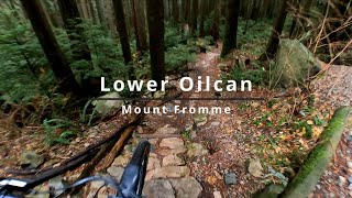
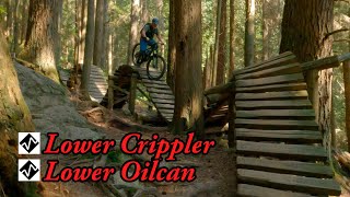
All mountain trail that meanders back and forth, at times pedally. Some technical bits and steeper sections will challenge the intermediate rider. Trail abruptly ends at a t-junction on the BP after a steep fall line chute. Turn left then head down Skid Rd for a rubble fest that will take you to Skid Road Reroute offering an option to climb sections of No Quarter or continue to Lower Dreamweaver by descending further down Skid Rd and hanging a left.

Access Info

Accessed off Mountain Hwy and exits on the Baden Powell.

Trail Supporters

  • Michael Stormer
    Builder
  • Daniel Shaw
    Builder
  • Rob Donovan
    Builder
  • past supporters

Local Trail Association

Recent Activity on Trail

Past Week
  • 15 rides
  • 15.5 km average
6 Months
  • 190 rides
  • 13.4 km avg distance
All
  • 2,458 rides
  • Last: Jun 16, 2026
c1c2c3c4
January
February
March
April
May
June
July
August
September
October
November
December
update trails status or condition

Lower Oilcan Trail Reports

Status:
on Jun 9, 2026
Ideal
Avg: 4.06 (78 votes)
Your vote: 0

view (13,999)
close
3D
Trail Conditions
  • Unknown
  • Snow Groomed
  • Snow Packed
  • Snow Covered
  • Snow Cover Partial
  • Freeze/thaw Cycle
  • Icy
  • Prevalent Mud
  • Wet
  • Variable
  • Ideal
  • Dry
  • Very Dry
Trail Flow (Ridden Direction)
Trailforks scans users ridelogs to determine the most popular direction each trail is ridden. A good flowing trail network will have most trails flowing in a single direction according to their intension.
The colour categories are based on what percentage of riders are riding a trail in its intended direction.
  • > 96%
  • > 90%
  • > 80%
  • > 70%
  • > 50%
  • < 50%
  • bi-directional trail
  • no data
Trail Last Ridden
Trailforks scans ridelogs to determine the last time a trail was ridden.
  • < 2 days
  • < 1 week
  • < 2 weeks
  • < 1 month
  • < 6 months
  • > 6 months
Trail Ridden Direction
The intended direction a trail should be ridden.
  • Downhill Only
  • Downhill Primary
  • Both Directions
  • Uphill Primary
  • Uphill Only
  • One Direction
Contribute Details
Colors indicate trail is missing specified detail.
  • Description
  • Photos
  • Description & Photos
  • Videos
Trail Popularity ?
Trailforks scans ridelogs to determine which trails are ridden the most in the last 9 months. Trails are compared with nearby trails in the same city region with a possible 25 colour shades. Think of this as a heatmap, more rides = more kinetic energy = warmer colors.
  • most popular
  • popular
  • less popular
  • not popular
ATV/ORV/OHV Filter
Max Vehicle Width
inches
US Cell Coverage
Legend
cell carrier legend

Radar Time
Activity Recordings
Trailforks uses anonymized public activity data. ?
Activity Recordings
Trailforks uses anonymized public activity data. ?
Personal Heatmap
Activity Types
all / none
Options
2
Date range month
Winter Trails
Warning A routing network for winter maps does not exist. Selecting trails using the winter trails layer has been disabled.
Missing Trails
Most Popular
Least Popular
Trails are colored based on popularity. The more popular a trail is, the more red. Less popular trails trend towards green.
Jump Magnitude Heatmap
Heatmap of where riders jump on trails. Zoom in to see individual jumps, click circles to view jump details.
BC Backroad Status

Service Road Atlas is a free to use, community-driven service for viewing and creating reports on the numerous back-country service roads around B.C. and Alberta.

map legend
Slope Aspect
Direction the slope faces
Flat N NE E SE S SW W NW
Trails Deemphasized
Trails are shown in grey.
disable
Only show trails with no bike usage.
Enable
Suggested Layers
Based on selected activity type

    Save the current map location and zoom level as your default home location whenever this page is loaded.

    Save
        Directions to lower-oilcan trailhead (49.358060, -123.056590)

        Photos

        425 more »
        771 |
        May 28, 2016 @ 8:18pm
        May 28, 2016
        560 |
        May 12, 2016 @ 1:19am
        May 12, 2016
        783 |
        May 12, 2016 @ 12:48am
        May 12, 2016
        1,160 |
        Jul 22, 2009 @ 10:13pm
        Jul 22, 2009

        Videos

        26 more »
        youtuber FULL SPEED INTO ROCKS AND ROOTS // Oil Can,...
        6:19 | 1944 | Oct 17, 2018 , North Vancouver
        Lower Oilcan | Rough & Rowdy on Fromme....
        4:48 | 181 | Nov 29, 2025 , North Vancouver
        youtuber Lower Oilcan and Lower Crippler
        13:27 | 260 | Oct 11, 2024 , North Vancouver
        One Thing At A Time
        4:43 | 116 | Aug 23, 2024 , North Vancouver

        Trail Lists

        Routes with this trail

        5 miles 1,627 ft 9
        Training route for climbing training
        10 miles 3,025 ft 19 Point to Point
        Collection of new climbing connectors and some old trail creating a Fromme west side access climbing...
        4 miles 671 ft 17 Point to Point
        Route used by Pedalheads Mountain Biking (PHMB) Camps. Location: North Vancouver Level: Advanced Day 1...

        13 Reviews & Comments


        We hope you've been enjoying Trailforks!

        Create a FREE account to view trail comments and much more.

        • By canadakaTF Pro Trailforks & contributors
        • #153 - 27,080 views

        Frequently Asked Questions About Lower Oilcan

        Where is Lower Oilcan located?
        Lower Oilcan is located in Mount Fromme, North Vancouver, British Columbia, Canada. It is part of the Mount Fromme trail network. The trailhead is located at coordinates 49.35806, -123.05659.
        How hard is Lower Oilcan?
        Lower Oilcan is rated as Black Diamond difficulty. The physical rating is Moderate. The average grade is 18.2%.
        What is the elevation gain for Lower Oilcan?
        The trail has 161 m of elevation descent. The elevation ranges from 471 m to 632 m.
        Is Lower Oilcan a point to point trail?
        Lower Oilcan is not a point to point trail. The direction is Downhill Primary. The trail type is singletrack.

        Hit the Trail

        Open in App

        Get this trail on your phone instantly.
        open trail in app

        Download Trail

        Save to wishlist, Garmin & download.
        save the trail

        Find Related Routes

        Find routes and users activities that include this trail.
        find routes for this trail

        You must enter a description before submitting.