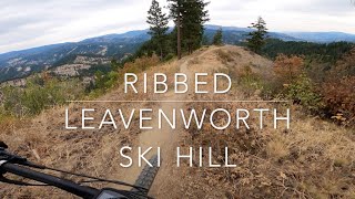
more stats
1.1 miles
Distance
64 ft
Climb
-717 ft
Descent
00:07:08
Avg time
-654 ft
Altitude change
1,529 ft
Altitude min
2,182 ft
Altitude max
2,182 ft
Altitude start
1,529 ft
Altitude end
-11%
Grade
-43.4%
Grade max
24.2%
Grade min
797 ft
Distance climb
4,564 ft
Distance down
528 ft
Distance flat
00:07:08
Avg time

Lower Ribbed Trail Details

  • Activities
    • Mountain Bike
    • E-Bike
  • Riding Area
    Leavenworth Hill
    Leavenworth, Washington
  • Difficulty Rating
  • Voted Difficulty
    Black Diamond (4 votes)
  • Local Popularity
    100 in Mountain Biking [+]
    • 90 in E-Biking
  • Global Ranking
    #24617 in Mountain Biking [+]
    • #2493 in E-Biking
  • Trail Type
    Singletrack
  • Bike Type
    DH, AM
  • Direction
    Downhill Only
    Popular Direction Shown
  • Climb Difficulty
    Double Black Diamond
  • Physical Rating
    Moderate
  • Dogs Allowed
    Yes
  • eBike Allowed
  • TTFs on Trail
    Berm, Drop, Jump, Gap Jump

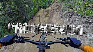
This trail has 25'-30' table tops toward the bottom, hence the double black rating, but don't let that scare you away - anyone comfortable on the ground can have fun here too. Some huge G-outs, an insanely steep switchback, and lots and lots of jumps, but everything can be rolled or avoided.

If you like amazing trails like the newly rebuilt Ribbed trail, support Washington's non-profit Evergreen Mountain Bike Alliance who built it Get a membership. Send them your companies matching donations. Share some of that bonus at work. It directly goes to the construction of trails like this one! https://www.givebig2019.org/evergreen-mountain-bike-alliance

Local Trail Association
Traditionally Indigenous Territory

Recent Activity on Trail

Past Week
  • 0 rides
  •  
6 Months
  • 49 rides
  • 12 miles avg distance
All
  • 411 rides
  • Last: Jun 19, 2026
c1c2c3c4
January
February
March
April
May
June
July
August
September
October
November
December
update trails status or condition

Lower Ribbed Trail Trail Reports

statusdatedescription
May 26, 2026 @ 12:37am (America/Los_Angeles)
May 26, 2026
Right Hip Alley! Multiple new smaller tables, a few gaps and bigger hips on the lower reclaimed log road section. They didn't just bulldoze the...
May 20, 2026 @ 10:03am (America/Vancouver)
May 20, 2026
Love the new work on the tables and jumps and easier alternatives. Good job Central...
May 16, 2026 @ 11:27am (America/Los_Angeles)
May 16, 2026
Excellent condition, lower section freshly rebuilt. Ran into 4 of the builders yesterday. Chased the sunshine and rode it again today....
Jun 24, 2025 @ 8:09am
Jun 24, 2025
Awesome describes it! [L=https://www.evergreenmtb.org/trails/ride-reports/rr-9192]Evergreen MTB Report[/L]
May 30, 2025 @ 9:08am
May 30, 2025
Shaded enough to be awesome still. [L=https://www.evergreenmtb.org/trails/ride-reports/rr-9140]Evergreen MTB Report[/L]
more »
Status:
on May 26, 2026
Snow Cover Partial
Avg: 4.3 (25 votes)
Your vote: 0

view (2,549)
close
3D
Trail Conditions
  • Unknown
  • Snow Groomed
  • Snow Packed
  • Snow Covered
  • Snow Cover Partial
  • Freeze/thaw Cycle
  • Icy
  • Prevalent Mud
  • Wet
  • Variable
  • Ideal
  • Dry
  • Very Dry
Trail Flow (Ridden Direction)
Trailforks scans users ridelogs to determine the most popular direction each trail is ridden. A good flowing trail network will have most trails flowing in a single direction according to their intension.
The colour categories are based on what percentage of riders are riding a trail in its intended direction.
  • > 96%
  • > 90%
  • > 80%
  • > 70%
  • > 50%
  • < 50%
  • bi-directional trail
  • no data
Trail Last Ridden
Trailforks scans ridelogs to determine the last time a trail was ridden.
  • < 2 days
  • < 1 week
  • < 2 weeks
  • < 1 month
  • < 6 months
  • > 6 months
Trail Ridden Direction
The intended direction a trail should be ridden.
  • Downhill Only
  • Downhill Primary
  • Both Directions
  • Uphill Primary
  • Uphill Only
  • One Direction
Contribute Details
Colors indicate trail is missing specified detail.
  • Description
  • Photos
  • Description & Photos
  • Videos
Trail Popularity ?
Trailforks scans ridelogs to determine which trails are ridden the most in the last 9 months. Trails are compared with nearby trails in the same city region with a possible 25 colour shades. Think of this as a heatmap, more rides = more kinetic energy = warmer colors.
  • most popular
  • popular
  • less popular
  • not popular
ATV/ORV/OHV Filter
Max Vehicle Width
inches
US Cell Coverage
Legend
cell carrier legend

Radar Time
Activity Recordings
Trailforks uses anonymized public activity data. ?
Activity Recordings
Trailforks uses anonymized public activity data. ?
Personal Heatmap
Activity Types
all / none
Options
2
Date range month
Winter Trails
Warning A routing network for winter maps does not exist. Selecting trails using the winter trails layer has been disabled.
Missing Trails
Most Popular
Least Popular
Trails are colored based on popularity. The more popular a trail is, the more red. Less popular trails trend towards green.
Jump Magnitude Heatmap
Heatmap of where riders jump on trails. Zoom in to see individual jumps, click circles to view jump details.
BC Backroad Status

Service Road Atlas is a free to use, community-driven service for viewing and creating reports on the numerous back-country service roads around B.C. and Alberta.

map legend
Slope Aspect
Direction the slope faces
Flat N NE E SE S SW W NW
Trails Deemphasized
Trails are shown in grey.
disable
Only show trails with no bike usage.
Enable
Suggested Layers
Based on selected activity type

    Save the current map location and zoom level as your default home location whenever this page is loaded.

    Save
        Directions to lower-ribbed-trail trailhead (47.627830, -120.666280)

        Photos

        19 more »
        35 |
        Apr 15, 2026 @ 2:15pm
        Apr 15, 2026
        38 |
        Apr 15, 2026 @ 11:54am
        Apr 15, 2026
        43 |
        Apr 15, 2026 @ 11:53am
        Apr 15, 2026
        84 |
        Aug 21, 2024 @ 8:49pm
        Aug 21, 2024

        Videos

        6 more »
        youtuber Lower Ribbed just got better: New jumps...
        9:07 | 23 | Jun 2, 2026 , Leavenworth
        Ribbed - Leavenworth Ski Hill - Leavenworth,...
        13:08 | 682 | Oct 11, 2023 , Leavenworth
        Ribbed Trail - Freund Creek MTB [4K]
        9:38 | 718 | May 15, 2022 , Leavenworth
        Leavenworth MTB Jump Line! // Ribbed (GoPro Max)
        11:32 | 1107 | Oct 15, 2020 , Leavenworth

        Routes with this trail

        23 miles 5,910 ft 13 Loop
        This is a great loop that can be ridden from town and incorporates all 3 Ski Hill flow trails without...
        13 miles 2,963 ft 20
        Easiest way to ride trail from ski hill parking lot.
        24 miles 5,411 ft 9 Loop Race
        Beginning at the Leavenworth Ski Hill, pro riders will race Leavenworth's best single track through old...

        12 Reviews & Comments


        We hope you've been enjoying Trailforks!

        Create a FREE account to view trail comments and much more.

        • By ashlemonTF Pro & contributors
        • #178705 - 8,385 views

        Frequently Asked Questions About Lower Ribbed Trail

        Where is Lower Ribbed Trail located?
        Lower Ribbed Trail is located in Leavenworth Hill, Leavenworth, Washington, United States. It is part of the Leavenworth Hill trail network. The trailhead is located at coordinates 47.62783, -120.66628.
        How hard is Lower Ribbed Trail?
        Lower Ribbed Trail is rated as Double Black Diamond difficulty. The physical rating is Moderate. The average grade is 11%. The climb difficulty is rated Double Black Diamond.
        What is the elevation gain for Lower Ribbed Trail?
        Lower Ribbed Trail has 64 ft of elevation gain. The trail has 717 ft of elevation descent. The elevation ranges from 1,529 ft to 2,182 ft.
        Is Lower Ribbed Trail a point to point trail?
        Yes, Lower Ribbed Trail is a point to point trail. The direction is Downhill Only. The trail type is singletrack.

        Hit the Trail

        Open in App

        Get this trail on your phone instantly.
        open trail in app

        Download Trail

        Save to wishlist, Garmin & download.
        save the trail

        Find Related Routes

        Find routes and users activities that include this trail.
        find routes for this trail

        You must enter a description before submitting.