more stats
705 ft
Distance
-50 ft
Descent
00:00:17
Avg time
-50 ft
Altitude change
8,935 ft
Altitude min
8,985 ft
Altitude max
8,985 ft
Altitude start
8,937 ft
Altitude end
-7%
Grade
-13.1%
Grade max
-2.9%
Grade min
705 ft
Distance down
00:00:17
Avg time

Lower Richter Details

  • Activities
    • Mountain Bike
  • Riding Area
    Mammoth Mountain Bike Park
    Mammoth Lakes, California
  • Difficulty Rating
  • Voted Difficulty
    Black Diamond (1 vote)
  • Local Popularity
    50 in Mountain Biking
  • Global Ranking
    #49211 in Mountain Biking
  • Trail Type
    Singletrack
  • Bike Type
    DH
  • Direction
    Downhill Only
    Popular Direction Shown
  • Climb Difficulty
    Green
  • Physical Rating
    Hard
  • Dogs Allowed
    Yes
  • TTFs on Trail
    Berm, Drop, Jump, Rock Garden, Skinny

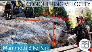
The trail starts with a massive step up into the woods. There are a few jumps and a technical section before a long, steep ladder drops you back out of the woods.

Access Info

Start from Kamikaze or upper Richter. The trail ends across the road from the gondola building.

Trail Supporters

  • USFS
    Land Manager

Bike Park

Recent Activity on Trail

Past Week
  • 0 rides
  •  
6 Months
  • 2 rides
  • 36 miles avg distance
All
  • 288 rides
  • Last: May 10, 2026
c1c2c3c4
January
February
March
April
May
June
July
August
September
October
November
December
update trails status or condition

Lower Richter Trail Reports

statusdatedescription
Jul 10, 2025 @ 1:49pm
Jul 10, 2025
And.... it's closed again.
Jul 8, 2025 @ 10:28pm
Jul 8, 2025
Reopened. Not sure why it was even closed. Ramp is still closed.
Jun 30, 2025 @ 11:59pm
Jun 30, 2025
Closed as of 6/30. No idea why. Was riding fine on 6/29
Aug 10, 2024 @ 1:39am
Aug 10, 2024
There are so many roots and rocks that you don't really need to even think about how dry the dirt is.
Jul 20, 2024 @ 7:23am
Jul 20, 2024
more »
Status:
on Jul 10, 2025
Dry
Avg: 4.19 (9 votes)
Your vote: 0

view (5,559)
close
3D
Trail Conditions
  • Unknown
  • Snow Groomed
  • Snow Packed
  • Snow Covered
  • Snow Cover Partial
  • Freeze/thaw Cycle
  • Icy
  • Prevalent Mud
  • Wet
  • Variable
  • Ideal
  • Dry
  • Very Dry
Trail Flow (Ridden Direction)
Trailforks scans users ridelogs to determine the most popular direction each trail is ridden. A good flowing trail network will have most trails flowing in a single direction according to their intension.
The colour categories are based on what percentage of riders are riding a trail in its intended direction.
  • > 96%
  • > 90%
  • > 80%
  • > 70%
  • > 50%
  • < 50%
  • bi-directional trail
  • no data
Trail Last Ridden
Trailforks scans ridelogs to determine the last time a trail was ridden.
  • < 2 days
  • < 1 week
  • < 2 weeks
  • < 1 month
  • < 6 months
  • > 6 months
Trail Ridden Direction
The intended direction a trail should be ridden.
  • Downhill Only
  • Downhill Primary
  • Both Directions
  • Uphill Primary
  • Uphill Only
  • One Direction
Contribute Details
Colors indicate trail is missing specified detail.
  • Description
  • Photos
  • Description & Photos
  • Videos
Trail Popularity ?
Trailforks scans ridelogs to determine which trails are ridden the most in the last 9 months. Trails are compared with nearby trails in the same city region with a possible 25 colour shades. Think of this as a heatmap, more rides = more kinetic energy = warmer colors.
  • most popular
  • popular
  • less popular
  • not popular
ATV/ORV/OHV Filter
Max Vehicle Width
inches
US Cell Coverage
Legend
cell carrier legend

Radar Time
Activity Recordings
Trailforks uses anonymized public activity data. ?
Activity Recordings
Trailforks uses anonymized public activity data. ?
Personal Heatmap
Activity Types
all / none
Options
2
Date range month
Winter Trails
Warning A routing network for winter maps does not exist. Selecting trails using the winter trails layer has been disabled.
Missing Trails
Most Popular
Least Popular
Trails are colored based on popularity. The more popular a trail is, the more red. Less popular trails trend towards green.
Jump Magnitude Heatmap
Heatmap of where riders jump on trails. Zoom in to see individual jumps, click circles to view jump details.
BC Backroad Status

Service Road Atlas is a free to use, community-driven service for viewing and creating reports on the numerous back-country service roads around B.C. and Alberta.

map legend
Slope Aspect
Direction the slope faces
Flat N NE E SE S SW W NW
Trails Deemphasized
Trails are shown in grey.
disable
Only show trails with no bike usage.
Enable
Suggested Layers
Based on selected activity type

    Save the current map location and zoom level as your default home location whenever this page is loaded.

    Save
        Directions to lower-richter trailhead (37.647950, -119.039460)

        Photos

        No photos have been added for Lower Richter yet, add a photo.

        Videos

        4 more »
        Off the Top - Beach Cruiser - White Bark -...
        18:46 | 143 | Nov 2, 2021 , Mammoth Lakes
        MTB Riding White Bark and Richter on Mammoth...
        12:40 | 153 | Nov 1, 2021 , Mammoth Lakes
        UNP26 - Velocity - Adaptive MTB - Mammoth Bike...
        17:27 | 198 | Dec 5, 2019 , Mammoth Lakes
        UNCUT - Lower Richter - Adaptive MTB - Mammoth...
        0:49 | 273 | Dec 5, 2019 , Mammoth Lakes

        Trail Lists

        Routes with this trail

        6 miles 36 ft 15 Point to Point
        This route skips all the major dilemmas on and is do-able solo for most adaptive riders. There is a short...
        7 miles 44 ft 11
        This is my go-to warm up route. Off the Top and Beach Cruiser are fast and easy while White Bark and...

        Trail Products

        1 Review & Comments


        We hope you've been enjoying Trailforks!

        Create a FREE account to view trail comments and much more.

        • By TheAngryTomatoTF Pro TRAILFORKS & contributors
        • #25043 - 1,946 views

        Frequently Asked Questions About Lower Richter

        Where is Lower Richter located?
        Lower Richter is located in Mammoth Mountain Bike Park, Mammoth Lakes, California, United States. It is part of the Mammoth Mountain Bike Park trail network. The trailhead is located at coordinates 37.64795, -119.03946.
        How hard is Lower Richter?
        Lower Richter is rated as Black Diamond difficulty. The physical rating is Hard. The average grade is 7%. The climb difficulty is rated Green.
        What is the elevation gain for Lower Richter?
        The trail has 50 ft of elevation descent. The elevation ranges from 8,935 ft to 8,985 ft.
        Is Lower Richter a point to point trail?
        Yes, Lower Richter is a point to point trail. The direction is Downhill Only. The trail type is singletrack.

        Hit the Trail

        Open in App

        Get this trail on your phone instantly.
        open trail in app

        Download Trail

        Save to wishlist, Garmin & download.
        save the trail

        Find Related Routes

        Find routes and users activities that include this trail.
        find routes for this trail

        You must enter a description before submitting.