more stats
4,249 ft
Distance
28 ft
Climb
-396 ft
Descent
00:05:41
Avg time
-370 ft
Altitude change
2,285 ft
Altitude min
2,662 ft
Altitude max
2,656 ft
Altitude start
2,287 ft
Altitude end
-8.7%
Grade
-39.6%
Grade max
11.9%
Grade min
696 ft
Distance climb
3,186 ft
Distance down
354 ft
Distance flat
00:05:41
Avg time

Lower Schizo Details

  • Activities
    • Mountain Bike
    • E-Bike
    • Snowshoe
  • Riding Area
    South Canoe
    Salmon Arm, British Columbia
  • Difficulty Rating
  • Local Popularity
    100 in Mountain Biking [+]
    • 95 in E-Biking
    • 5 in Snowshoeing
  • Global Ranking
    #32813 in Mountain Biking [+]
    • #18405 in E-Biking
    • #2636 in Snowshoeing
  • Trail Type
    Singletrack
  • Bike Type
    AM, XC
  • Physical Rating
    Moderate
  • Dogs Allowed
    Yes
  • eBike Allowed
    Yes up to Class 1
  • TTFs on Trail
    A-Frame, Berm, Bridge, Drop, Jump, Ladder Bridge, Rock Garden
  • Land Owner
    http://www.sitesandtrailsbc.ca/

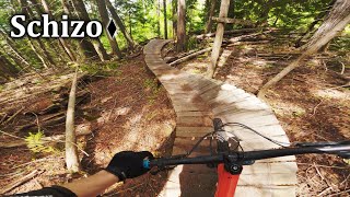
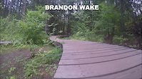
The main link from the upper network back into the lower trails. A couple bridges and a couple steeper sections which are greasy in the wet. Very fast and fun.

Access Info

Can be accessed by Metford Road near the tall red and white tower.

Trail Supporters
Local Trail Association
Traditionally Indigenous Territory

Recent Activity on Trail

Past Week
  • 9 rides
  • 8 miles average
6 Months
  • 195 rides
  • 16 miles avg distance
All
  • 1,304 rides
  • Last: Jun 19, 2026
c1c2c3c4
January
February
March
April
May
June
July
August
September
October
November
December
update trails status or condition

Lower Schizo Trail Reports

statusdatedescription
Apr 6, 2026 @ 1:59pm (America/Vancouver)
Apr 6, 2026
reporter Down tree about 6’ above the Willy’s bog bridge.
Mar 20, 2026 @ 6:01pm (America/Vancouver)
Mar 20, 2026
great conditions as of today.
May 11, 2025 @ 10:00am
May 11, 2025
Apr 11, 2025 @ 6:28pm
Apr 11, 2025
Mar 31, 2025 @ 4:31pm
Mar 31, 2025
reporter Muddy spots
more »
Status:
on Apr 6, 2026
Ideal
Avg: 4.42 (13 votes)
Your vote: 0

view (7,941)
close
3D
Trail Conditions
  • Unknown
  • Snow Groomed
  • Snow Packed
  • Snow Covered
  • Snow Cover Partial
  • Freeze/thaw Cycle
  • Icy
  • Prevalent Mud
  • Wet
  • Variable
  • Ideal
  • Dry
  • Very Dry
Trail Flow (Ridden Direction)
Trailforks scans users ridelogs to determine the most popular direction each trail is ridden. A good flowing trail network will have most trails flowing in a single direction according to their intension.
The colour categories are based on what percentage of riders are riding a trail in its intended direction.
  • > 96%
  • > 90%
  • > 80%
  • > 70%
  • > 50%
  • < 50%
  • bi-directional trail
  • no data
Trail Last Ridden
Trailforks scans ridelogs to determine the last time a trail was ridden.
  • < 2 days
  • < 1 week
  • < 2 weeks
  • < 1 month
  • < 6 months
  • > 6 months
Trail Ridden Direction
The intended direction a trail should be ridden.
  • Downhill Only
  • Downhill Primary
  • Both Directions
  • Uphill Primary
  • Uphill Only
  • One Direction
Contribute Details
Colors indicate trail is missing specified detail.
  • Description
  • Photos
  • Description & Photos
  • Videos
Trail Popularity ?
Trailforks scans ridelogs to determine which trails are ridden the most in the last 9 months. Trails are compared with nearby trails in the same city region with a possible 25 colour shades. Think of this as a heatmap, more rides = more kinetic energy = warmer colors.
  • most popular
  • popular
  • less popular
  • not popular
ATV/ORV/OHV Filter
Max Vehicle Width
inches
US Cell Coverage
Legend
cell carrier legend

Radar Time
Activity Recordings
Trailforks uses anonymized public activity data. ?
Activity Recordings
Trailforks uses anonymized public activity data. ?
Personal Heatmap
Activity Types
all / none
Options
2
Date range month
Winter Trails
Warning A routing network for winter maps does not exist. Selecting trails using the winter trails layer has been disabled.
Missing Trails
Most Popular
Least Popular
Trails are colored based on popularity. The more popular a trail is, the more red. Less popular trails trend towards green.
Jump Magnitude Heatmap
Heatmap of where riders jump on trails. Zoom in to see individual jumps, click circles to view jump details.
BC Backroad Status

Service Road Atlas is a free to use, community-driven service for viewing and creating reports on the numerous back-country service roads around B.C. and Alberta.

map legend
Slope Aspect
Direction the slope faces
Flat N NE E SE S SW W NW
Trails Deemphasized
Trails are shown in grey.
disable
Only show trails with no bike usage.
Enable
Suggested Layers
Based on selected activity type

    Save the current map location and zoom level as your default home location whenever this page is loaded.

    Save
        Directions to lower-schizo trailhead (50.688250, -119.183770)

        Photos

        24 more »
        139 |
        Sep 29, 2020 @ 3:15pm
        Sep 29, 2020
        198 |
        Sep 29, 2020 @ 3:11pm
        Sep 29, 2020
        219 |
        Jul 6, 2020 @ 5:36pm
        Jul 6, 2020
        178 |
        Jul 6, 2020 @ 5:36pm
        Jul 6, 2020

        Videos

        3 more »
        Schizo - South Canoe
        6:32 | 151 | Oct 5, 2024 , Salmon Arm
        Lower Schitzo to Flying Nun
        7:11 | 745 | Aug 30, 2016 , Salmon Arm
        south canoe trails
        3:48 | 396 | Aug 25, 2016 , Salmon Arm

        Routes with this trail

        4.6 6 miles 1,131 ft 10 Loop Race
        The Salty Dog 6-Hour Enduro is one of the longest running mountain bike races in B.C. – Ride solo or in...
        32 miles 6,301 ft 36 Race
        Stage 2 of the 2022 BC Bike Race
        11 miles 2,446 ft 15 Race
        Frost Dog Fat Bike Enduro - 2023. Stage 1 - - KC to just before the connection with . Stage 2 - ALL THE...

        4 Reviews & Comments


        We hope you've been enjoying Trailforks!

        Create a FREE account to view trail comments and much more.

        • By sutra STAB & contributors
        • #49477 - 3,551 views

        Frequently Asked Questions About Lower Schizo

        Where is Lower Schizo located?
        Lower Schizo is located in South Canoe, Salmon Arm, British Columbia, Canada. It is part of the South Canoe trail network. The trailhead is located at coordinates 50.68825, -119.18377.
        How hard is Lower Schizo?
        Lower Schizo is rated as Blue difficulty. The physical rating is Moderate. The average grade is 8.7%.
        What is the elevation gain for Lower Schizo?
        Lower Schizo has 8 m of elevation gain. The trail has 121 m of elevation descent. The elevation ranges from 697 m to 811 m.
        How long is Lower Schizo?
        Lower Schizo is 1.3 km long. The trail type is singletrack.

        Hit the Trail

        Open in App

        Get this trail on your phone instantly.
        open trail in app

        Download Trail

        Save to wishlist, Garmin & download.
        save the trail

        Find Related Routes

        Find routes and users activities that include this trail.
        find routes for this trail

        You must enter a description before submitting.