more stats
1.3 miles
Distance
6 ft
Climb
-809 ft
Descent
00:09:24
Avg time
-804 ft
Altitude change
9,962 ft
Altitude min
10,771 ft
Altitude max
10,766 ft
Altitude start
9,964 ft
Altitude end
-12%
Grade
-39.2%
Grade max
8.9%
Grade min
121 ft
Distance climb
1 mile
Distance down
538 ft
Distance flat
00:09:24
Avg time

Timberline Details

  • Activities
    • Mountain Bike
  • Riding Area
    Brian Head Resort
    Brian Head, Utah
  • Difficulty Rating
  • Voted Difficulty
    Black Diamond (3 votes)
  • Local Popularity
    65 in Mountain Biking
  • Global Ranking
    #66568 in Mountain Biking
  • Trail Type
    Singletrack
  • Bike Type
    DH, AM
  • TTFs on Trail
    Drop, Jump, Log Ride
  • Land Owner
    USFS

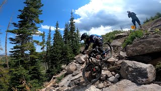
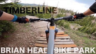
This is a favorite downhill trail for riders that like a mix of technical rocks, some little log drops, and generally loose, but not so steep and loose. Some of the big embedded rocks allow you to roll, send or even go around. A little bit of wood work on one turn, and couple wood senders make it fun to air out a bit.

Once you get most the way down the trail traverses along the slope giving you multiple descent options. If you continue along the trail to the end the trail will become the Malicious Woods trail. The actual timberline trail turns right right after the pass under the lift. There you drop down through the trees with some more big rock technical riding. The trail ends with a little sender off what looks like an old car. Pretty easy, you can kind of roll it with just a little speed or boost the whole car out of the woods and put on the show for riders waiting to catch the next lift.

Trail Supporters

  • USFS
    Land Manager

Bike Park

Local Trail Association
  • trail association logo
  • Please consider joining or donating to the local trail association to support
    trail development & maintenance.
Traditionally Indigenous Territory

Recent Activity on Trail

Past Week
  • 1 rides
  • 46 miles average
6 Months
  • 1 rides
  • 46 miles avg distance
All
  • 151 rides
  • Last: Jun 19, 2026
c1c2c3c4
January
February
March
April
May
June
July
August
September
October
November
December
update trails status or condition

Timberline Trail Reports

statusdatedescription
Sep 21, 2025 @ 7:15pm (America/Denver)
Sep 21, 2025
Fantastic!
Sep 1, 2025 @ 8:49am
Sep 1, 2025
Aug 23, 2025 @ 9:57am
Aug 23, 2025
Jul 28, 2025 @ 2:31pm
Jul 28, 2025
Jul 2, 2025 @ 9:40am
Jul 2, 2025
overnight rains, hero dirt! Trail crew has cleaned up trails, best I've seen them!
more »
Status:
on Sep 21, 2025
Ideal
Avg: 4.15 (9 votes)
Your vote: 0

view (1,974)
close
3D
Trail Conditions
  • Unknown
  • Snow Groomed
  • Snow Packed
  • Snow Covered
  • Snow Cover Partial
  • Freeze/thaw Cycle
  • Icy
  • Prevalent Mud
  • Wet
  • Variable
  • Ideal
  • Dry
  • Very Dry
Trail Flow (Ridden Direction)
Trailforks scans users ridelogs to determine the most popular direction each trail is ridden. A good flowing trail network will have most trails flowing in a single direction according to their intension.
The colour categories are based on what percentage of riders are riding a trail in its intended direction.
  • > 96%
  • > 90%
  • > 80%
  • > 70%
  • > 50%
  • < 50%
  • bi-directional trail
  • no data
Trail Last Ridden
Trailforks scans ridelogs to determine the last time a trail was ridden.
  • < 2 days
  • < 1 week
  • < 2 weeks
  • < 1 month
  • < 6 months
  • > 6 months
Trail Ridden Direction
The intended direction a trail should be ridden.
  • Downhill Only
  • Downhill Primary
  • Both Directions
  • Uphill Primary
  • Uphill Only
  • One Direction
Contribute Details
Colors indicate trail is missing specified detail.
  • Description
  • Photos
  • Description & Photos
  • Videos
Trail Popularity ?
Trailforks scans ridelogs to determine which trails are ridden the most in the last 9 months. Trails are compared with nearby trails in the same city region with a possible 25 colour shades. Think of this as a heatmap, more rides = more kinetic energy = warmer colors.
  • most popular
  • popular
  • less popular
  • not popular
ATV/ORV/OHV Filter
Max Vehicle Width
inches
US Cell Coverage
Legend
cell carrier legend

Radar Time
Activity Recordings
Trailforks uses anonymized public activity data. ?
Activity Recordings
Trailforks uses anonymized public activity data. ?
Personal Heatmap
Activity Types
all / none
Options
2
Date range month
Winter Trails
Warning A routing network for winter maps does not exist. Selecting trails using the winter trails layer has been disabled.
Missing Trails
Most Popular
Least Popular
Trails are colored based on popularity. The more popular a trail is, the more red. Less popular trails trend towards green.
Jump Magnitude Heatmap
Heatmap of where riders jump on trails. Zoom in to see individual jumps, click circles to view jump details.
BC Backroad Status

Service Road Atlas is a free to use, community-driven service for viewing and creating reports on the numerous back-country service roads around B.C. and Alberta.

map legend
Slope Aspect
Direction the slope faces
Flat N NE E SE S SW W NW
Trails Deemphasized
Trails are shown in grey.
disable
Only show trails with no bike usage.
Enable
Suggested Layers
Based on selected activity type

    Save the current map location and zoom level as your default home location whenever this page is loaded.

    Save
        Directions to timberline-11823 trailhead (37.686620, -112.832600)

        Photos

        10 more »
        65 |
        Aug 21, 2023 @ 3:42pm
        Aug 21, 2023
        183 |
        Sep 7, 2020 @ 12:15am
        Sep 7, 2020
        350 |
        Jun 23, 2020 @ 11:00am
        Jun 23, 2020
        403 |
        Aug 23, 2019 @ 10:26am
        Aug 23, 2019

        Videos

        6 more »
        Brianhead, Utah July 2021
        9:42 | 284 | Jul 30, 2021 , Brian Head
        Brian Head Bike Park: Every Trail from...
        28:44 | 227 | Jul 8, 2021 , Brian Head
        youtuber Brian Head Bike Park - TIMBERLINE TRAIL -...
        9:06 | 510 | Aug 21, 2020 , Brian Head
        YouTube
        28:14 | 231 | Jul 1, 2020 , Brian Head

        Routes with this trail

        33 miles 6,818 ft 19
        This 2-day event will showcase some of the best riding in Utah and this venue will challenge racers with...
        35 miles 7,679 ft 11 Race
        The 2021 Big Mountain Enduro Finals will culminate on September 18-19 in beautiful Brian Head, UT. This...
        33 miles 7,471 ft 14 Race
        This 2-day event will showcase some of the best riding in Utah and this venue will challenge racers with...

        2 Reviews & Comments


        We hope you've been enjoying Trailforks!

        Create a FREE account to view trail comments and much more.

        • By toddTF Pro Trailforks & contributors
        • #11823 - 4,078 views

        Frequently Asked Questions About Timberline

        Where is Timberline located?
        Timberline is located in Brian Head Resort, Brian Head, Utah, United States. It is part of the Brian Head Resort trail network. The trailhead is located at coordinates 37.68662, -112.8326.
        How hard is Timberline?
        Timberline is rated as Black Diamond difficulty. The average grade is 12%.
        What is the elevation gain for Timberline?
        Timberline has 6 ft of elevation gain. The trail has 809 ft of elevation descent. The elevation ranges from 9,962 ft to 10,771 ft.
        How long is Timberline?
        Timberline is 1.3 miles long. The trail type is singletrack.

        Hit the Trail

        Open in App

        Get this trail on your phone instantly.
        open trail in app

        Download Trail

        Save to wishlist, Garmin & download.
        save the trail

        Find Related Routes

        Find routes and users activities that include this trail.
        find routes for this trail

        You must enter a description before submitting.