more stats
1.8 miles
Distance
-431 ft
Descent
00:08:31
Avg time
-431 ft
Altitude change
4,506 ft
Altitude min
4,939 ft
Altitude max
4,937 ft
Altitude start
4,505 ft
Altitude end
-4.6%
Grade
-17.5%
Grade max
2.1%
Grade min
118 ft
Distance climb
2 miles
Distance down
863 ft
Distance flat
00:08:31
Avg time

Whoops (Lower) Details

  • Activities
    • Mountain Bike
    • E-Bike
    • Adaptive Bike
    • Hike
    • Trail Running
  • Riding Area
    Phil's
    Bend, Oregon
  • Difficulty Rating
  • Local Popularity
    100 in Mountain Biking [+]
    • 55 in Trail Running
    • 85 in Hiking
  • Global Ranking
    #519 in Mountain Biking [+]
    • #1026 in Trail Running
    • #1309 in Hiking
  • Trail Type
    Singletrack
  • Bike Type
    AM, XC, Adaptive MTB
  • Direction
    Downhill Only
    Popular Direction Shown
  • Dogs Allowed
    Yes
  • eBike Allowed
    Yes up to Class 1
  • TTFs on Trail
    Berm, Jump
  • Land Owner
    USFS - Deschutes Ranger District
  • OSM Way

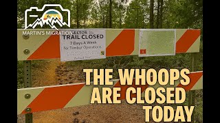
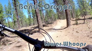
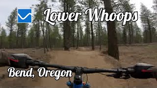
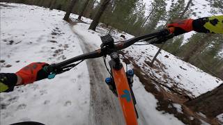
One of the most fun trails in the area. This trail is fast and fun. Multiple jump options and some that you can get pretty good air on. You can roll all the jumps, but there are some optional lines for some pretty big table tops. Rip through the trees, hit the berms, and then grind up the dirt road back to the top

Adaptive Bike Info
aMTB Blue Rating: Intermediate features and steeper terrain.

aMTB rating is provided for general information only and may not reflect the technical difficulty of the trail or a particular rider's support needs. COTA completed a trail assessment process, please find more information on our website: https://www.cotamtb.com/amtb-trail-information.html. Contact Oregon Adaptive Sports for more information or ride support: https://oregonadaptivesports.org.

Trail Supporters

  • USFS
    Land Manager
Local Trail Association

Recent Activity on Trail

Past Week
  • 37 rides
  • 20 miles average
6 Months
  • 516 rides
  • 14 miles avg distance
All
  • 5,199 rides
  • Last: Jun 21, 2026
c1c2c3c4
January
February
March
April
May
June
July
August
September
October
November
December
Status:
on Jun 6, 2026
Dry
Avg: 4.45 (90 votes)
Your vote: 0

view (27,951)
close
3D
Trail Conditions
  • Unknown
  • Snow Groomed
  • Snow Packed
  • Snow Covered
  • Snow Cover Partial
  • Freeze/thaw Cycle
  • Icy
  • Prevalent Mud
  • Wet
  • Variable
  • Ideal
  • Dry
  • Very Dry
Trail Flow (Ridden Direction)
Trailforks scans users ridelogs to determine the most popular direction each trail is ridden. A good flowing trail network will have most trails flowing in a single direction according to their intension.
The colour categories are based on what percentage of riders are riding a trail in its intended direction.
  • > 96%
  • > 90%
  • > 80%
  • > 70%
  • > 50%
  • < 50%
  • bi-directional trail
  • no data
Trail Last Ridden
Trailforks scans ridelogs to determine the last time a trail was ridden.
  • < 2 days
  • < 1 week
  • < 2 weeks
  • < 1 month
  • < 6 months
  • > 6 months
Trail Ridden Direction
The intended direction a trail should be ridden.
  • Downhill Only
  • Downhill Primary
  • Both Directions
  • Uphill Primary
  • Uphill Only
  • One Direction
Contribute Details
Colors indicate trail is missing specified detail.
  • Description
  • Photos
  • Description & Photos
  • Videos
Trail Popularity ?
Trailforks scans ridelogs to determine which trails are ridden the most in the last 9 months. Trails are compared with nearby trails in the same city region with a possible 25 colour shades. Think of this as a heatmap, more rides = more kinetic energy = warmer colors.
  • most popular
  • popular
  • less popular
  • not popular
ATV/ORV/OHV Filter
Max Vehicle Width
inches
US Cell Coverage
Legend
cell carrier legend

Radar Time
Activity Recordings
Trailforks uses anonymized public activity data. ?
Activity Recordings
Trailforks uses anonymized public activity data. ?
Personal Heatmap
Activity Types
all / none
Options
2
Date range month
Winter Trails
Warning A routing network for winter maps does not exist. Selecting trails using the winter trails layer has been disabled.
Missing Trails
Most Popular
Least Popular
Trails are colored based on popularity. The more popular a trail is, the more red. Less popular trails trend towards green.
Jump Magnitude Heatmap
Heatmap of where riders jump on trails. Zoom in to see individual jumps, click circles to view jump details.
BC Backroad Status

Service Road Atlas is a free to use, community-driven service for viewing and creating reports on the numerous back-country service roads around B.C. and Alberta.

map legend
Slope Aspect
Direction the slope faces
Flat N NE E SE S SW W NW
Trails Deemphasized
Trails are shown in grey.
disable
Only show trails with no bike usage.
Enable
Suggested Layers
Based on selected activity type

    Save the current map location and zoom level as your default home location whenever this page is loaded.

    Save
        Directions to whoops-lower trailhead (44.025010, -121.490520)

        Photos

        54 more »
        1,989 |
        May 16, 2013 @ 10:06am
        May 16, 2013
        2,856 |
        Nov 19, 2013 @ 9:17am
        Nov 19, 2013
        112 |
        Dec 14, 2025 @ 11:59am
        Dec 14, 2025
        112 |
        May 5, 2024 @ 10:41pm
        May 5, 2024

        Videos

        19 more »
        The Whoops Are Closed | An Awkward Mountain...
        18:47 | 43 | Jan 21, 2026 , Bend
        MTB Bend, Oregon - Lower Whoops (2025)
        6:50 | 145 | Aug 10, 2025 , Bend
        Lower Whoops at Phil's Riding Area in Bend, Oregon
        7:36 | 241 | Jan 4, 2025 , Bend
        Lower Whoops Trail -- Bend, Oregon
        4:34 | 209 | Nov 23, 2024 , Bend

        Routes with this trail

        4.0 4 miles 478 ft 2
        Cross country style climb up Pinedrops, followed by a flowy descent with jumps on . Repeat this loop as...
        5.0 22 miles 1,057 ft 6 Shuttled
        One ride hitting some of the best trails in town. Start on Flagline from the Dutchman Flats Sno-Park...
        4.2 8 miles 1,138 ft 4 Loop
        Whoops Loop with climb on road

        Trail Products

        7 Reviews & Comments


        We hope you've been enjoying Trailforks!

        Create a FREE account to view trail comments and much more.

        Frequently Asked Questions About Whoops (Lower)

        Where is Whoops (Lower) located?
        Whoops (Lower) is located in Phil's, Bend, Oregon, United States. It is part of the Phil's trail network. The trailhead is located at coordinates 44.02501, -121.49052.
        How hard is Whoops (Lower)?
        Whoops (Lower) is rated as Blue difficulty. The average grade is 4.6%.
        What is the elevation gain for Whoops (Lower)?
        The trail has 431 ft of elevation descent. The elevation ranges from 4,506 ft to 4,939 ft.
        Is Whoops (Lower) a point to point trail?
        Yes, Whoops (Lower) is a point to point trail. The direction is Downhill Only. The trail type is singletrack.

        Hit the Trail

        Open in App

        Get this trail on your phone instantly.
        open trail in app

        Download Trail

        Save to wishlist, Garmin & download.
        save the trail

        Find Related Routes

        Find routes and users activities that include this trail.
        find routes for this trail

        You must enter a description before submitting.