more stats
1,680 ft
Distance
-139 ft
Descent
00:08:24
Avg time
-141 ft
Altitude change
1,891 ft
Altitude min
2,032 ft
Altitude max
2,032 ft
Altitude start
1,893 ft
Altitude end
-8.4%
Grade
-27.8%
Grade max
2.3%
Grade min
56 ft
Distance climb
1,302 ft
Distance down
299 ft
Distance flat
00:08:24
Avg time

Lower Yer Saddle Details

  • Activities
    • Mountain Bike
    • Hike
    • Trail Running
  • Riding Area
    Cheakamus
    Whistler, British Columbia
  • Difficulty Rating
  • Local Popularity
    20 in Mountain Biking [+]
    • 35 in Trail Running
    • 20 in Hiking
  • Global Ranking
    #114779 in Mountain Biking [+]
    • #123777 in Trail Running
    • #114895 in Hiking
  • Trail Type
    Singletrack
  • Bike Type
    AM, XC
  • Direction
    Downhill Primary
    Popular Direction Shown
  • Physical Rating
    Moderate
  • Dogs Allowed
    Yes
  • TTFs on Trail
    Bridge, Ladder Bridge, Rock Face

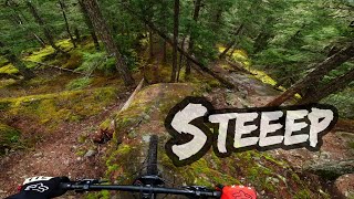
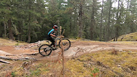
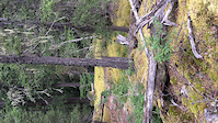
Pretty fun trail. Starts with two optional ways to climb to the top of a rock. There's two (double-black-ish) rock faces from the top, one of which ends in a big wooden bridge. After that, the trail descends a series of easier, rolly rock faces. The trail crosses a fancy bridge and then spits you out at the railroad. The ride-arounds on the trail can be pretty janky, and while the rock faces are pretty committing, they aren't actually that hard.

Local Trail Association

Recent Activity on Trail

Past Week
  • 0 rides
  •  
6 Months
  • 2 rides
  • 8 miles avg distance
All
  • 125 rides
  • Last: May 3, 2026
c1c2c3c4
January
February
March
April
May
June
July
August
September
October
November
December
update trails status or condition

Lower Yer Saddle Trail Reports

statusdatedescription
Apr 6, 2026 @ 3:57pm (America/Vancouver)
Apr 6, 2026
re-establish the trail to the rail crossing, and up the other side. Good to go.
Apr 5, 2026 @ 5:09pm (America/Vancouver)
Apr 5, 2026
Good to go except the descent to the railroad crossing, which was decommissioned by CN
Mar 6, 2026 @ 8:05am (America/Los_Angeles)
Mar 6, 2026
We cleared the blowdown trees down to the river. Still a few smaller trees across the trail from the river to the start of Runaway Train which can...
May 3, 2025 @ 6:24am
May 3, 2025
Aug 1, 2024 @ 4:49pm
Aug 1, 2024
reporter
more »
Status:
on Apr 6, 2026
Ideal
Avg: 4.55 (12 votes)
Your vote: 0

view (638)
close
3D
Trail Conditions
  • Unknown
  • Snow Groomed
  • Snow Packed
  • Snow Covered
  • Snow Cover Partial
  • Freeze/thaw Cycle
  • Icy
  • Prevalent Mud
  • Wet
  • Variable
  • Ideal
  • Dry
  • Very Dry
Trail Flow (Ridden Direction)
Trailforks scans users ridelogs to determine the most popular direction each trail is ridden. A good flowing trail network will have most trails flowing in a single direction according to their intension.
The colour categories are based on what percentage of riders are riding a trail in its intended direction.
  • > 96%
  • > 90%
  • > 80%
  • > 70%
  • > 50%
  • < 50%
  • bi-directional trail
  • no data
Trail Last Ridden
Trailforks scans ridelogs to determine the last time a trail was ridden.
  • < 2 days
  • < 1 week
  • < 2 weeks
  • < 1 month
  • < 6 months
  • > 6 months
Trail Ridden Direction
The intended direction a trail should be ridden.
  • Downhill Only
  • Downhill Primary
  • Both Directions
  • Uphill Primary
  • Uphill Only
  • One Direction
Contribute Details
Colors indicate trail is missing specified detail.
  • Description
  • Photos
  • Description & Photos
  • Videos
Trail Popularity ?
Trailforks scans ridelogs to determine which trails are ridden the most in the last 9 months. Trails are compared with nearby trails in the same city region with a possible 25 colour shades. Think of this as a heatmap, more rides = more kinetic energy = warmer colors.
  • most popular
  • popular
  • less popular
  • not popular
ATV/ORV/OHV Filter
Max Vehicle Width
inches
US Cell Coverage
Legend
cell carrier legend

Radar Time
Activity Recordings
Trailforks uses anonymized public activity data. ?
Activity Recordings
Trailforks uses anonymized public activity data. ?
Personal Heatmap
Activity Types
all / none
Options
2
Date range month
Winter Trails
Warning A routing network for winter maps does not exist. Selecting trails using the winter trails layer has been disabled.
Missing Trails
Most Popular
Least Popular
Trails are colored based on popularity. The more popular a trail is, the more red. Less popular trails trend towards green.
Jump Magnitude Heatmap
Heatmap of where riders jump on trails. Zoom in to see individual jumps, click circles to view jump details.
BC Backroad Status

Service Road Atlas is a free to use, community-driven service for viewing and creating reports on the numerous back-country service roads around B.C. and Alberta.

map legend
Slope Aspect
Direction the slope faces
Flat N NE E SE S SW W NW
Trails Deemphasized
Trails are shown in grey.
disable
Only show trails with no bike usage.
Enable
Suggested Layers
Based on selected activity type

    Save the current map location and zoom level as your default home location whenever this page is loaded.

    Save
        Directions to lower-yer-saddle trailhead (50.083400, -123.058750)

        Photos

        39 more »
        389 |
        Jun 7, 2017 @ 9:51pm
        Jun 7, 2017
        688 |
        Aug 24, 2014 @ 11:27pm
        Aug 24, 2014
        61 |
        Feb 13, 2024 @ 5:45pm
        Feb 13, 2024
        58 |
        Feb 13, 2024 @ 5:45pm
        Feb 13, 2024

        Videos

        6 more »
        Places to visit in Whistler 'Train Wreck' |...
        4:26 | 109 | Apr 21, 2024 , Whistler
        LOWER YER SADDLE 4K - NEW JERRYS ON THE BLOCK
        0:05 | 497 | Sep 15, 2020 , Whistler
        Rock Rolls Austin Jewett
        0:45 | 236 | Aug 15, 2018 , Whistler
        Back at it
        0:15 | 81 | Sep 4, 2017 , Whistler

        Trail Lists

        Routes with this trail

        25 miles 5,110 ft 22
        2020 Cheakamus trail supporter challenge.
        2 miles 253 ft 7 Race
        The Seventh WORCA Virtual Toonie. Back to Cheakmus! Cause who Doesn't love these trails! In order to earn...

        Trail Products

        5 Reviews & Comments


        We hope you've been enjoying Trailforks!

        Create a FREE account to view trail comments and much more.

        Frequently Asked Questions About Lower Yer Saddle

        Where is Lower Yer Saddle located?
        Lower Yer Saddle is located in Cheakamus, Whistler, British Columbia, Canada. It is part of the Cheakamus trail network. The trailhead is located at coordinates 50.0834, -123.05875.
        How hard is Lower Yer Saddle?
        Lower Yer Saddle is rated as Black Diamond difficulty. The physical rating is Moderate. The average grade is 8.4%.
        What is the elevation gain for Lower Yer Saddle?
        The trail has 42 m of elevation descent. The elevation ranges from 576 m to 619 m.
        Is Lower Yer Saddle a point to point trail?
        Lower Yer Saddle is not a point to point trail. The direction is Downhill Primary. The trail type is singletrack.

        Hit the Trail

        Open in App

        Get this trail on your phone instantly.
        open trail in app

        Download Trail

        Save to wishlist, Garmin & download.
        save the trail

        Find Related Routes

        Find routes and users activities that include this trail.
        find routes for this trail

        You must enter a description before submitting.