more stats
1.8 miles
Distance
17 ft
Climb
-1,810 ft
Descent
00:14:54
Avg time
-1,793 ft
Altitude change
527 ft
Altitude min
2,320 ft
Altitude max
2,320 ft
Altitude start
528 ft
Altitude end
-18.9%
Grade
-82%
Grade max
20.3%
Grade min
210 ft
Distance climb
2 miles
Distance down
69 ft
Distance flat
00:14:54
Avg time

Machete 3.0 Details

  • Activities
    • Mountain Bike
    • Hike
    • Trail Running
  • Riding Area
  • Difficulty Rating
  • Voted Difficulty
    Secondary Access Road/Trail (2 votes)
  • Local Popularity
    95 in Mountain Biking [+]
    • 5 in Trail Running
    • 5 in Hiking
  • Global Ranking
    #29397 in Mountain Biking [+]
    • #127128 in Trail Running
    • #120345 in Hiking
  • Hiking SAC Scale
    T2 Mountain Hiking
  • Trail Type
    Singletrack
  • Bike Type
    DH, AM, XC
  • Direction
    Downhill Primary
    Popular Direction Shown
  • Climb Difficulty
    Blue
  • Physical Rating
    Moderate
  • eBike Allowed
    Yes up to Class 1
  • TTFs on Trail
    Drop, Rock Garden
  • Year Opened
    2016
  • Land Owner
    Italia

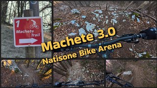
Please use this instead of old Machete 2.0.
The trail is CLOSED on wednesdays and sundays from 01.09 to 31.12

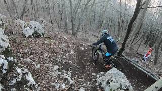
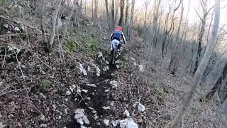
One of the most famous and fulfilling trails of the Natisone Bike Arena. A very mixed trail with different difficulties and terrains. It starts with some steepy tight turns, then after a short pathway jumps into a short but not so easy rockgarden to be dealt carefully. After a flat fast part starts the most flow part full of turns and counterslopes. Then a steepy canyon and a short flat path leads into the "GamePark", a serie of banked turns followed by a reeeeally fast part that brings to the last part of the trail. - We suggest STRICLY to speed down as you approach the village -
On the most technical and difficult passages we also made a Tofu (Chicken) line for the beginners. On these lines is possible to ride (but carefully) also on wet conditions even if, in this situation, is suitable only to advanced riders.

ASD Machete Team

Local Trail Association

Recent Activity on Trail

Past Week
  • 0 rides
  •  
6 Months
  • 18 rides
  • 25.7 km avg distance
All
  • 94 rides
  • Last: Jun 14, 2026
c1c2c3c4
January
February
March
April
May
June
July
August
September
October
November
December
update trails status or condition

Machete 3.0 Trail Reports

statusdatedescription
May 4, 2026 @ 9:00pm (Europe/Rome)
May 4, 2026
Dec 13, 2025 @ 9:38am (Europe/Ljubljana)
Dec 13, 2025
Impegnativo, per esperti, percorso in ottime condizioni
Nov 8, 2025 @ 5:13pm (Europe/Rome)
Nov 8, 2025
Many leafes on the trail.
Nov 8, 2025 @ 3:59am (Europe/Rome)
Nov 7, 2025
Lots of leaves on the ground and some rain runnels from the last storm, which makes riding fast very hard :P
Sep 10, 2025 @ 6:17am
Sep 10, 2025
Trail interamente ripulito e liberato da tutti gli schianti.
more »
Status:
on May 4, 2026
Ideal
Avg: 4.46 (18 votes)
Your vote: 0

view (917)
close
3D
Trail Conditions
  • Unknown
  • Snow Groomed
  • Snow Packed
  • Snow Covered
  • Snow Cover Partial
  • Freeze/thaw Cycle
  • Icy
  • Prevalent Mud
  • Wet
  • Variable
  • Ideal
  • Dry
  • Very Dry
Trail Flow (Ridden Direction)
Trailforks scans users ridelogs to determine the most popular direction each trail is ridden. A good flowing trail network will have most trails flowing in a single direction according to their intension.
The colour categories are based on what percentage of riders are riding a trail in its intended direction.
  • > 96%
  • > 90%
  • > 80%
  • > 70%
  • > 50%
  • < 50%
  • bi-directional trail
  • no data
Trail Last Ridden
Trailforks scans ridelogs to determine the last time a trail was ridden.
  • < 2 days
  • < 1 week
  • < 2 weeks
  • < 1 month
  • < 6 months
  • > 6 months
Trail Ridden Direction
The intended direction a trail should be ridden.
  • Downhill Only
  • Downhill Primary
  • Both Directions
  • Uphill Primary
  • Uphill Only
  • One Direction
Contribute Details
Colors indicate trail is missing specified detail.
  • Description
  • Photos
  • Description & Photos
  • Videos
Trail Popularity ?
Trailforks scans ridelogs to determine which trails are ridden the most in the last 9 months. Trails are compared with nearby trails in the same city region with a possible 25 colour shades. Think of this as a heatmap, more rides = more kinetic energy = warmer colors.
  • most popular
  • popular
  • less popular
  • not popular
ATV/ORV/OHV Filter
Max Vehicle Width
inches
US Cell Coverage
Legend
cell carrier legend

Radar Time
Activity Recordings
Trailforks uses anonymized public activity data. ?
Activity Recordings
Trailforks uses anonymized public activity data. ?
Personal Heatmap
Activity Types
all / none
Options
2
Date range month
Winter Trails
Warning A routing network for winter maps does not exist. Selecting trails using the winter trails layer has been disabled.
Missing Trails
Most Popular
Least Popular
Trails are colored based on popularity. The more popular a trail is, the more red. Less popular trails trend towards green.
Jump Magnitude Heatmap
Heatmap of where riders jump on trails. Zoom in to see individual jumps, click circles to view jump details.
BC Backroad Status

Service Road Atlas is a free to use, community-driven service for viewing and creating reports on the numerous back-country service roads around B.C. and Alberta.

map legend
Slope Aspect
Direction the slope faces
Flat N NE E SE S SW W NW
Trails Deemphasized
Trails are shown in grey.
disable
Only show trails with no bike usage.
Enable
Suggested Layers
Based on selected activity type

    Save the current map location and zoom level as your default home location whenever this page is loaded.

    Save
        Directions to machete-3-0 trailhead (46.138710, 13.462550)

        Photos

        15 more »
        242 |
        Feb 1, 2020 @ 7:00am
        Feb 1, 2020
        229 |
        Jan 29, 2020 @ 12:33am
        Jan 29, 2020
        230 |
        Jan 29, 2020 @ 12:30am
        Jan 29, 2020
        267 |
        Jan 29, 2020 @ 12:30am
        Jan 29, 2020

        Videos

        6 more »
        Machete 3.0 - Enduro-MTB Trail im Valli del...
        9:14 | 305 | Feb 23, 2025 , San Pietro Al Natisone
        3 SENTIERI DA PROVARE (SECONDO ME) NELLA...
        20:45 | 420 | Mar 24, 2023 , San Pietro Al Natisone
        Machete Trail Rocco Line nuova variante
        0:23 | 732 | Jan 30, 2020 , San Pietro Al Natisone
        Machete Trail TofuLine
        0:36 | 463 | Jan 30, 2020 , San Pietro Al Natisone

        Routes with this trail

        3.0 8 miles 1,995 ft 6
        Giro al Machete da Vernasso

        10 Reviews & Comments


        We hope you've been enjoying Trailforks!

        Create a FREE account to view trail comments and much more.

        • By maxmisdarisTF Pro MGNR & contributors
        • #82143 - 8,487 views

        Frequently Asked Questions About Machete 3.0

        Where is Machete 3.0 located?
        Machete 3.0 is located in Natisone Bike Arena (S.Pietro/Pulfero), San Pietro Al Natisone, Italy. It is part of the Natisone Bike Arena (S.Pietro/Pulfero) trail network. The trailhead is located at coordinates 46.13871, 13.46255.
        How hard is Machete 3.0?
        Machete 3.0 is rated as Red difficulty. The physical rating is Moderate. The average grade is 18.9%. The climb difficulty is rated Blue.
        What is the elevation gain for Machete 3.0?
        Machete 3.0 has 5 m of elevation gain. The trail has 552 m of elevation descent. The elevation ranges from 161 m to 707 m.
        Is Machete 3.0 a point to point trail?
        Machete 3.0 is not a point to point trail. The direction is Downhill Primary. The trail type is singletrack.

        Hit the Trail

        Open in App

        Get this trail on your phone instantly.
        open trail in app

        Download Trail

        Save to wishlist, Garmin & download.
        save the trail

        Find Related Routes

        Find routes and users activities that include this trail.
        find routes for this trail

        You must enter a description before submitting.