more stats
1,070 ft
Distance
-74 ft
Descent
00:03:04
Avg time
-75 ft
Altitude change
1,139 ft
Altitude min
1,214 ft
Altitude max
1,214 ft
Altitude start
1,138 ft
Altitude end
-7%
Grade
-22.4%
Grade max
-0.7%
Grade min
20 ft
Distance climb
843 ft
Distance down
207 ft
Distance flat
00:03:04
Avg time

Mad Hatter (Upper) Details

  • Activities
    • Mountain Bike
    • E-Bike
    • Gravel Bike
    • Hike
    • Trail Running
  • Riding Area
    Blowing Springs
    Bella Vista, Arkansas
  • Difficulty Rating
  • Local Popularity
    90 in Mountain Biking [+]
    • 95 in E-Biking
    • 55 in Trail Running
    • 55 in Hiking
  • Global Ranking
    #6256 in Mountain Biking [+]
    • #5386 in E-Biking
    • #105400 in Trail Running
    • #89370 in Hiking
  • Hiking SAC Scale
    T2 Mountain Hiking
  • Trail Type
    Doubletrack
  • Bike Type
    DH, AM, XC, DJ, Fat, Adaptive MTB, Gravel
  • Direction
    Downhill Only[+]
    Popular Direction Shown
    • Downhill Only for Gravel Biking
  • Physical Rating
    Moderate
  • Trail Visibility
    Always easy to follow
  • eBike Allowed
    Yes up to Class 1
  • TTFs on Trail
    Berm, Bridge, Jump
  • Year Opened
    2020

No community description for Mad Hatter (Upper) trail has been added yet!

AI Generated Description

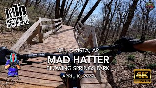
Mad Hatter (Upper) is a highly rated 1,070 ft popular blue difficulty doubletrack trail located near Bella Vista Arkansas. This multi-use trail can be used downhill only and has a moderate overall physical rating. It features berm, bridge and jump. Adaptive MTB rating: amtb blue. Trail visibility is always easy to follow. On average it takes 3 minutes to complete this trail.

Adaptive Bike Info
aMTB Blue Rating: Intermediate features and steeper terrain.

The trail itself is rated aMTB1x (no support needed with advanced features) but the exit may require assistance. Solo adaptive riders must exit using Woz Up to the south. Exiting using Through the Looking Glass via Woz Up to the north requires assistance.

Local Trail Association

Recent Activity on Trail

Past Week
  • 2 rides
  • 15 miles average
6 Months
  • 139 rides
  • 14 miles avg distance
All
  • 1,044 rides
  • Last: Jun 21, 2026
c1c2c3c4
January
February
March
April
May
June
July
August
September
October
November
December
Status:
on Jun 13, 2026
Ideal
Avg: 4.28 (9 votes)
Your vote: 0

view (12,534)
close
3D
Trail Conditions
  • Unknown
  • Snow Groomed
  • Snow Packed
  • Snow Covered
  • Snow Cover Partial
  • Freeze/thaw Cycle
  • Icy
  • Prevalent Mud
  • Wet
  • Variable
  • Ideal
  • Dry
  • Very Dry
Trail Flow (Ridden Direction)
Trailforks scans users ridelogs to determine the most popular direction each trail is ridden. A good flowing trail network will have most trails flowing in a single direction according to their intension.
The colour categories are based on what percentage of riders are riding a trail in its intended direction.
  • > 96%
  • > 90%
  • > 80%
  • > 70%
  • > 50%
  • < 50%
  • bi-directional trail
  • no data
Trail Last Ridden
Trailforks scans ridelogs to determine the last time a trail was ridden.
  • < 2 days
  • < 1 week
  • < 2 weeks
  • < 1 month
  • < 6 months
  • > 6 months
Trail Ridden Direction
The intended direction a trail should be ridden.
  • Downhill Only
  • Downhill Primary
  • Both Directions
  • Uphill Primary
  • Uphill Only
  • One Direction
Contribute Details
Colors indicate trail is missing specified detail.
  • Description
  • Photos
  • Description & Photos
  • Videos
Trail Popularity ?
Trailforks scans ridelogs to determine which trails are ridden the most in the last 9 months. Trails are compared with nearby trails in the same city region with a possible 25 colour shades. Think of this as a heatmap, more rides = more kinetic energy = warmer colors.
  • most popular
  • popular
  • less popular
  • not popular
ATV/ORV/OHV Filter
Max Vehicle Width
inches
US Cell Coverage
Legend
cell carrier legend

Radar Time
Activity Recordings
Trailforks uses anonymized public activity data. ?
Activity Recordings
Trailforks uses anonymized public activity data. ?
Personal Heatmap
Activity Types
all / none
Options
2
Date range month
Winter Trails
Warning A routing network for winter maps does not exist. Selecting trails using the winter trails layer has been disabled.
Missing Trails
Most Popular
Least Popular
Trails are colored based on popularity. The more popular a trail is, the more red. Less popular trails trend towards green.
Jump Magnitude Heatmap
Heatmap of where riders jump on trails. Zoom in to see individual jumps, click circles to view jump details.
BC Backroad Status

Service Road Atlas is a free to use, community-driven service for viewing and creating reports on the numerous back-country service roads around B.C. and Alberta.

map legend
Slope Aspect
Direction the slope faces
Flat N NE E SE S SW W NW
Trails Deemphasized
Trails are shown in grey.
disable
Only show trails with no bike usage.
Enable
Suggested Layers
Based on selected activity type

    Save the current map location and zoom level as your default home location whenever this page is loaded.

    Save
        Directions to mad-hatter-upper trailhead (36.429650, -94.221160)

        Photos

        13 more »
        40 |
        Oct 14, 2025 @ 2:51pm
        Oct 14, 2025
        75 |
        Sep 22, 2024 @ 7:39am
        Sep 22, 2024
        150 |
        Nov 14, 2022 @ 11:19am
        Nov 14, 2022
        132 |
        Nov 14, 2022 @ 11:19am
        Nov 14, 2022

        Videos

        13 more »
        youtuber MTB Riding | Mad Hatter | Blowing Springs Park...
        2:37 | 278 | Jun 6, 2024 , Bella Vista
        Mad Hatter (Upper and Lower) 04/07/2023
        0:28 | 181 | Apr 14, 2023 , Bella Vista
        Mad Hatter with Mason Dekeyrel
        0:00 | 225 | Jan 14, 2023 , Bella Vista
        MTB FPV TRAIN CHASE | Mad Hatter Flow Check
        0:17 | 185 | Jan 14, 2023 , Bella Vista

        Routes with this trail

        5.0 9 miles 1,035 ft 21
        This is a fun ride that links together the Blowing Springs and Alice in Wonderland Trails. There are lots...
        4.0 6 miles 703 ft 11 Loop
        This route is intended for adaptive riders to access the Wonderland DH trails, but is great for all. It...
        5.0 138 miles 12,933 ft 95
        This is the route Payson McElveen posted on his strava for the Bentonville trail challenge 2021.

        2 Reviews & Comments


        We hope you've been enjoying Trailforks!

        Create a FREE account to view trail comments and much more.

        • By hogankoesisTF Pro DMP & contributors
        • #382410 - 4,951 views

        Frequently Asked Questions About Mad Hatter (Upper)

        Where is Mad Hatter (Upper) located?
        Mad Hatter (Upper) is located in Blowing Springs, Bella Vista, Arkansas, United States. It is part of the Blowing Springs trail network. The trailhead is located at coordinates 36.42965, -94.22116.
        How hard is Mad Hatter (Upper)?
        Mad Hatter (Upper) is rated as Blue difficulty. The physical rating is Moderate. The average grade is 7%.
        What is the elevation gain for Mad Hatter (Upper)?
        The trail has 74 ft of elevation descent. The elevation ranges from 1,139 ft to 1,214 ft.
        Is Mad Hatter (Upper) a point to point trail?
        Yes, Mad Hatter (Upper) is a point to point trail. The direction is Downhill Only. The trail type is doubletrack.

        Hit the Trail

        Open in App

        Get this trail on your phone instantly.
        open trail in app

        Download Trail

        Save to wishlist, Garmin & download.
        save the trail

        Find Related Routes

        Find routes and users activities that include this trail.
        find routes for this trail

        You must enter a description before submitting.