more stats
1.4 miles
Distance
49 ft
Climb
-417 ft
Descent
00:10:58
Avg time
-366 ft
Altitude change
457 ft
Altitude min
831 ft
Altitude max
831 ft
Altitude start
466 ft
Altitude end
-4.8%
Grade
-29.3%
Grade max
14.7%
Grade min
820 ft
Distance climb
1 mile
Distance down
545 ft
Distance flat
00:10:58
Avg time

Madrona Details

  • Activities
    • Mountain Bike
    • Adaptive Bike
    • Horse
    • Hike
    • Trail Running
  • Riding Area
  • Difficulty Rating
  • Local Popularity
    60 in Mountain Biking [+]
    • 75 in Trail Running
    • 75 in Hiking
    • 5 in Horseback
  • Global Ranking
    #30567 in Mountain Biking [+]
    • #80895 in Trail Running
    • #78319 in Hiking
  • Hiking SAC Scale
    T1 Hiking
  • Trail Type
    Singletrack
  • Bike Type
    AM, XC, Adaptive MTB
  • Direction
    Both Directions
  • Climb Difficulty
    Blue
  • Physical Rating
    Moderate
  • Season
    Late spring through late fall
  • Family Friendly
    Yes
  • eBike Allowed
  • Year Opened
    2022
  • Land Owner

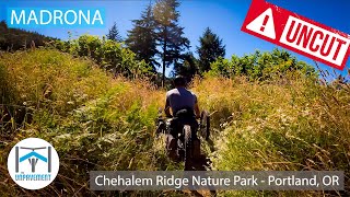
Peeling off from the Chehalem Ridge Trail in a dense forest, this trail quickly breaks into the open with views into the Tualatin Valley. It descends playfully down the hillside, cutting back and forth before intersecting with a gravel road. The trail continues for nearly half a mile on the gravel road (including up a steep hill) to another small segment of trail that loops around a meadow. While many riders may choose to turn around at the bottom of the main descent, the meadow loop is a worthy destination, especially in spring when the wildflowers are making their appearance.

Please be courteous and yield to pedestrians, equestrians, and ascending mountain bikers. Ride in control at all times, we're all outside, hoping to enjoy ourselves

Do not ride soil trails when they are wet, the damage can be difficult and costly to repair. The site has several improved-surface trails that can handle the rain so ride them when the other trails are muddy.

Metro parks do not allow dogs because unfortunately our canine friends are perceived as predators; impacting wildlife behavior, nesting, and feeding patterns. Please leave your pooch at home when riding at Chehalem Ridge. Thank you!

Adaptive Bike Info
aMTB Green Rating: Beginner features and moderate terrain.
Trail Supporters
Local Trail Association
Traditionally Indigenous Territory

Recent Activity on Trail

Past Week
  • 3 rides
  • 9 miles average
6 Months
  • 22 rides
  • 11 miles avg distance
All
  • 113 rides
  • Last: Jun 15, 2026
c1c2c3c4
January
February
March
April
May
June
July
August
September
October
November
December
update trails status or condition

Madrona Trail Reports

Status:
on May 3, 2026
Ideal
Avg: 3.88 (3 votes)
Your vote: 0

view (492)
close
3D
Trail Conditions
  • Unknown
  • Snow Groomed
  • Snow Packed
  • Snow Covered
  • Snow Cover Partial
  • Freeze/thaw Cycle
  • Icy
  • Prevalent Mud
  • Wet
  • Variable
  • Ideal
  • Dry
  • Very Dry
Trail Flow (Ridden Direction)
Trailforks scans users ridelogs to determine the most popular direction each trail is ridden. A good flowing trail network will have most trails flowing in a single direction according to their intension.
The colour categories are based on what percentage of riders are riding a trail in its intended direction.
  • > 96%
  • > 90%
  • > 80%
  • > 70%
  • > 50%
  • < 50%
  • bi-directional trail
  • no data
Trail Last Ridden
Trailforks scans ridelogs to determine the last time a trail was ridden.
  • < 2 days
  • < 1 week
  • < 2 weeks
  • < 1 month
  • < 6 months
  • > 6 months
Trail Ridden Direction
The intended direction a trail should be ridden.
  • Downhill Only
  • Downhill Primary
  • Both Directions
  • Uphill Primary
  • Uphill Only
  • One Direction
Contribute Details
Colors indicate trail is missing specified detail.
  • Description
  • Photos
  • Description & Photos
  • Videos
Trail Popularity ?
Trailforks scans ridelogs to determine which trails are ridden the most in the last 9 months. Trails are compared with nearby trails in the same city region with a possible 25 colour shades. Think of this as a heatmap, more rides = more kinetic energy = warmer colors.
  • most popular
  • popular
  • less popular
  • not popular
ATV/ORV/OHV Filter
Max Vehicle Width
inches
US Cell Coverage
Legend
cell carrier legend

Radar Time
Activity Recordings
Trailforks uses anonymized public activity data. ?
Activity Recordings
Trailforks uses anonymized public activity data. ?
Personal Heatmap
Activity Types
all / none
Options
2
Date range month
Winter Trails
Warning A routing network for winter maps does not exist. Selecting trails using the winter trails layer has been disabled.
Missing Trails
Most Popular
Least Popular
Trails are colored based on popularity. The more popular a trail is, the more red. Less popular trails trend towards green.
Jump Magnitude Heatmap
Heatmap of where riders jump on trails. Zoom in to see individual jumps, click circles to view jump details.
BC Backroad Status

Service Road Atlas is a free to use, community-driven service for viewing and creating reports on the numerous back-country service roads around B.C. and Alberta.

map legend
Slope Aspect
Direction the slope faces
Flat N NE E SE S SW W NW
Trails Deemphasized
Trails are shown in grey.
disable
Only show trails with no bike usage.
Enable
Suggested Layers
Based on selected activity type

    Save the current map location and zoom level as your default home location whenever this page is loaded.

    Save
        Directions to madrona trailhead (45.453980, -123.087630)

        Photos

        No photos have been added for Madrona yet, add a photo.

        Videos

        1 more »
        UNCUT Madrona - Adaptive MTB - Chehalem Ridge...
        9:22 | 653 | Aug 8, 2022 , Gaston

        Reviews / Comments

        No reviews yet, be the first to write a review or ask a question.
        Use trail reports to comment on trail conditions.


        We hope you've been enjoying Trailforks!

        Create a FREE account to view trail comments and much more.

        • By elvis-b & contributors
        • #533798 - 1,274 views

        Frequently Asked Questions About Madrona

        Where is Madrona located?
        Madrona is located in Chehalem Ridge Nature Park, Gaston, Oregon, United States. It is part of the Chehalem Ridge Nature Park trail network. The trailhead is located at coordinates 45.45398, -123.08763.
        How hard is Madrona?
        Madrona is rated as Blue difficulty. The physical rating is Moderate. The average grade is 4.8%. The climb difficulty is rated Blue.
        What is the elevation gain for Madrona?
        Madrona has 49 ft of elevation gain. The trail has 417 ft of elevation descent. The elevation ranges from 457 ft to 831 ft.
        Is Madrona a point to point trail?
        Madrona is not a point to point trail. The direction is Both Directions. The trail type is singletrack.

        Hit the Trail

        Open in App

        Get this trail on your phone instantly.
        open trail in app

        Download Trail

        Save to wishlist, Garmin & download.
        save the trail

        Find Related Routes

        Find routes and users activities that include this trail.
        find routes for this trail

        You must enter a description before submitting.