more stats
3,143 ft
Distance
9 ft
Climb
-329 ft
Descent
00:08:45
Avg time
-319 ft
Altitude change
258 ft
Altitude min
583 ft
Altitude max
577 ft
Altitude start
259 ft
Altitude end
-10.1%
Grade
-47.8%
Grade max
4.7%
Grade min
154 ft
Distance climb
2,684 ft
Distance down
308 ft
Distance flat
00:08:45
Avg time

Maidstone DH Details

  • Activities
    • Mountain Bike
    • E-Bike
    • Winter Fat Bike
  • Riding Area
  • Difficulty Rating
  • Local Popularity
    55 in Mountain Biking
  • Global Ranking
    #98908 in Mountain Biking
  • Trail Type
    Singletrack
  • Bike Type
    DH, AM
  • Direction
    Downhill Only[+]
    Popular Direction Shown
    • Downhill Only for E-Biking
    • Downhill Only for Winter Fat Biking
  • Climb Difficulty
    Green
  • Physical Rating
    Hard
  • Trail Visibility
    Always easy to follow
  • Season
    Oct - Apr
  • Dogs Allowed
    Yes
  • eBike Allowed
  • TTFs on Trail
    Berm, Bridge, Drop, Jump, Gap Jump, Ladder Bridge, Rock Face, Rock Garden, Skinny
  • Land Owner

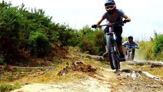
Technical downhill trail with multiple line choices all over. All these trails dry pretty well due to their exposure but are treacherous in the wet due to Upper Hutt's clay soil.

Access Info

Access to this trail is from the end of Seymore Grove in Kingsley Heights. Take the ridge line track to the start ofthis downhill.

Recent Activity on Trail

Past Week
  • 0 rides
  •  
6 Months
  • 1 rides
  • 5 miles avg distance
All
  • 23 rides
  • Last: May 3, 2026
c1c2c3c4
January
February
March
April
May
June
July
August
September
October
November
December
update trails status or condition

Maidstone DH Trail Reports

statusdatedescription
May 8, 2026 @ 8:41am (Pacific/Auckland)
May 7, 2026
Still riding well considering all the wet weather lately. Trail fairies have been at work on the middle steep section before entering the forest.
Apr 5, 2026 @ 7:56am (Pacific/Auckland)
Apr 4, 2026
Trail fairies have put in a little work through the middle section of this over the summer. Still riding really well.
Mar 21, 2025 @ 5:21pm
Mar 21, 2025
Needs work, lots of ruts and jumps are collapsing almost unridable
Jan 8, 2025 @ 6:42pm
Jan 8, 2025
Tons of ruts in the track, jumps are crumbling overgrown very sketchy
Jan 8, 2024 @ 3:23pm
Jan 8, 2024
Needs a bit of trimming and ladder drop needs to be refurbished, run in is a bit sketchy
more »
Status:
on May 8, 2026
Avg: 3.98 (1 votes)
Your vote: 0

view (331)
close
3D
Trail Conditions
  • Unknown
  • Snow Groomed
  • Snow Packed
  • Snow Covered
  • Snow Cover Partial
  • Freeze/thaw Cycle
  • Icy
  • Prevalent Mud
  • Wet
  • Variable
  • Ideal
  • Dry
  • Very Dry
Trail Flow (Ridden Direction)
Trailforks scans users ridelogs to determine the most popular direction each trail is ridden. A good flowing trail network will have most trails flowing in a single direction according to their intension.
The colour categories are based on what percentage of riders are riding a trail in its intended direction.
  • > 96%
  • > 90%
  • > 80%
  • > 70%
  • > 50%
  • < 50%
  • bi-directional trail
  • no data
Trail Last Ridden
Trailforks scans ridelogs to determine the last time a trail was ridden.
  • < 2 days
  • < 1 week
  • < 2 weeks
  • < 1 month
  • < 6 months
  • > 6 months
Trail Ridden Direction
The intended direction a trail should be ridden.
  • Downhill Only
  • Downhill Primary
  • Both Directions
  • Uphill Primary
  • Uphill Only
  • One Direction
Contribute Details
Colors indicate trail is missing specified detail.
  • Description
  • Photos
  • Description & Photos
  • Videos
Trail Popularity ?
Trailforks scans ridelogs to determine which trails are ridden the most in the last 9 months. Trails are compared with nearby trails in the same city region with a possible 25 colour shades. Think of this as a heatmap, more rides = more kinetic energy = warmer colors.
  • most popular
  • popular
  • less popular
  • not popular
ATV/ORV/OHV Filter
Max Vehicle Width
inches
US Cell Coverage
Legend
cell carrier legend

Radar Time
Activity Recordings
Trailforks uses anonymized public activity data. ?
Activity Recordings
Trailforks uses anonymized public activity data. ?
Personal Heatmap
Activity Types
all / none
Options
2
Date range month
Winter Trails
Warning A routing network for winter maps does not exist. Selecting trails using the winter trails layer has been disabled.
Missing Trails
Most Popular
Least Popular
Trails are colored based on popularity. The more popular a trail is, the more red. Less popular trails trend towards green.
Jump Magnitude Heatmap
Heatmap of where riders jump on trails. Zoom in to see individual jumps, click circles to view jump details.
BC Backroad Status

Service Road Atlas is a free to use, community-driven service for viewing and creating reports on the numerous back-country service roads around B.C. and Alberta.

map legend
Slope Aspect
Direction the slope faces
Flat N NE E SE S SW W NW
Trails Deemphasized
Trails are shown in grey.
disable
Only show trails with no bike usage.
Enable
Suggested Layers
Based on selected activity type

    Save the current map location and zoom level as your default home location whenever this page is loaded.

    Save
        Directions to maidstone-dh trailhead (-41.131100, 175.078370)

        Photos

        20 more »
        67 |
        Nov 30, 2020 @ 9:31pm
        Nov 30, 2020
        139 |
        Apr 9, 2020 @ 11:58pm
        Apr 9, 2020
        114 |
        Oct 19, 2018 @ 2:38am
        Oct 19, 2018
        100 |
        Oct 19, 2018 @ 2:38am
        Oct 19, 2018

        Videos

        13 more »
        Maidstone Max DH Trail - Upper Hutt, NZ
        2:27 | 1368 | Oct 11, 2019 , Upper Hutt
        Maidstone Dh
        0:59 | 2007 | Feb 19, 2019 , Upper Hutt
        Maidstone downhill 2019 'easy run'
        3:33 | 621 | Feb 19, 2019 , Upper Hutt
        MAIDSTONE DOWNHILL TRACK RAWRR
        0:33 | 1424 | Feb 19, 2019 , Upper Hutt

        Routes with this trail

        3,484 ft 52 ft 2 Shuttled
        This is the Downhill Course for the Cycling New Zealand Schools MTB Champs 2020. There is about 230m of...

        8 Reviews & Comments


        We hope you've been enjoying Trailforks!

        Create a FREE account to view trail comments and much more.

        • By nikholden & contributors
        • #17888 - 13,572 views

        Frequently Asked Questions About Maidstone DH

        Where is Maidstone DH located?
        Maidstone DH is located in Maidstone Max Downhill Trails, Upper Hutt, New Zealand. It is part of the Maidstone Max Downhill Trails trail network. The trailhead is located at coordinates -41.1311, 175.07837.
        How hard is Maidstone DH?
        Maidstone DH is rated as Black Diamond difficulty. The physical rating is Hard. The average grade is 10.1%. The climb difficulty is rated Green.
        What is the elevation gain for Maidstone DH?
        Maidstone DH has 9 ft of elevation gain. The trail has 329 ft of elevation descent. The elevation ranges from 258 ft to 583 ft.
        Is Maidstone DH a point to point trail?
        Yes, Maidstone DH is a point to point trail. The direction is Downhill Only. The trail type is singletrack.

        Hit the Trail

        Open in App

        Get this trail on your phone instantly.
        open trail in app

        Download Trail

        Save to wishlist, Garmin & download.
        save the trail

        Find Related Routes

        Find routes and users activities that include this trail.
        find routes for this trail

        You must enter a description before submitting.