more stats
4,075 ft
Distance
235 ft
Climb
-15 ft
Descent
00:09:32
Avg time
220 ft
Altitude change
714 ft
Altitude min
934 ft
Altitude max
714 ft
Altitude start
935 ft
Altitude end
5.4%
Grade
-6.6%
Grade max
23.9%
Grade min
2,851 ft
Distance climb
436 ft
Distance down
787 ft
Distance flat
00:09:32
Avg time

Mainline Details

  • Activities
    • Mountain Bike
    • E-Bike
    • Gravel Bike
    • Horse
    • Hike
    • Trail Running
  • Riding Area
    Boxley Creek
    North Bend, Washington
  • Difficulty Rating
  • Local Popularity
    75 in Mountain Biking [+]
    • 65 in E-Biking
    • 85 in Trail Running
    • 5 in Hiking
    • 5 in Horseback
  • Global Ranking
    #174320 in Mountain Biking [+]
    • #72717 in E-Biking
    • #71094 in Trail Running
    • #320258 in Hiking
    • #11051 in Horseback
  • Hiking SAC Scale
    T1 Hiking
  • Trail Type
    Singletrack
  • Bike Type
    AM, XC, Gravel
  • Direction
    Both Directions
    Popular Direction Shown
  • Climb Difficulty
    Blue
  • Physical Rating
    Moderate
  • Trail Visibility
    Sometimes hard to follow
  • Season
    Year round
  • Family Friendly
    Yes
  • Dogs Allowed
    Yes
  • eBike Allowed
    Yes up to Class 1
  • Ride in Rain
    Yes
  • Land Owner

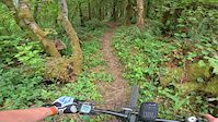
Main trail to climb from Snoqualmie Valley Trail to the downhill courses that start at the top of Boxley Creek. Middle section is flow with climbs at the beginning and end of trail. Multi directional with primary flow from east to west. Trail has several offshoots that can be mistaken as Mainline. Mainline is generally marked by orange tape.

Traditionally Indigenous Territory

Recent Activity on Trail

Past Week
  • 0 rides
  •  
6 Months
  • 20 rides
  • 9 miles avg distance
All
  • 130 rides
  • Last: Jun 7, 2026
c1c2c3c4
January
February
March
April
May
June
July
August
September
October
November
December
update trails status or condition

Mainline Trail Reports

statusdatedescription
Mar 23, 2026 @ 12:41pm (America/Vancouver)
Mar 23, 2026
Still needs logging tread work, buts downs cleared to top.
Mar 21, 2026 @ 5:03pm (America/Vancouver)
Mar 21, 2026
Mainline is clear from the SVT entrance to where the logging area ends. Some tread work still needs to occur, but cleared & raked/rideable....
Feb 27, 2026 @ 12:52pm (Pacific/Midway)
Feb 27, 2026
Mainline has major damage where it parallels the power line clearing. There is some sort of forest clearing activity with heavy equipment which...
Nov 22, 2025 @ 7:17pm (America/Los_Angeles)
Nov 22, 2025
Cleared. Went on rode most of the rest of the Box / didn't come across any others.
Nov 20, 2025 @ 1:56pm (America/Los_Angeles)
Nov 20, 2025
The trail is blocked by a substantial fallen tree at the top of the first climb.
more »
Status:
on Mar 23, 2026
Variable
no votes yet
Your vote: 0

view (720)
close
3D
Trail Conditions
  • Unknown
  • Snow Groomed
  • Snow Packed
  • Snow Covered
  • Snow Cover Partial
  • Freeze/thaw Cycle
  • Icy
  • Prevalent Mud
  • Wet
  • Variable
  • Ideal
  • Dry
  • Very Dry
Trail Flow (Ridden Direction)
Trailforks scans users ridelogs to determine the most popular direction each trail is ridden. A good flowing trail network will have most trails flowing in a single direction according to their intension.
The colour categories are based on what percentage of riders are riding a trail in its intended direction.
  • > 96%
  • > 90%
  • > 80%
  • > 70%
  • > 50%
  • < 50%
  • bi-directional trail
  • no data
Trail Last Ridden
Trailforks scans ridelogs to determine the last time a trail was ridden.
  • < 2 days
  • < 1 week
  • < 2 weeks
  • < 1 month
  • < 6 months
  • > 6 months
Trail Ridden Direction
The intended direction a trail should be ridden.
  • Downhill Only
  • Downhill Primary
  • Both Directions
  • Uphill Primary
  • Uphill Only
  • One Direction
Contribute Details
Colors indicate trail is missing specified detail.
  • Description
  • Photos
  • Description & Photos
  • Videos
Trail Popularity ?
Trailforks scans ridelogs to determine which trails are ridden the most in the last 9 months. Trails are compared with nearby trails in the same city region with a possible 25 colour shades. Think of this as a heatmap, more rides = more kinetic energy = warmer colors.
  • most popular
  • popular
  • less popular
  • not popular
ATV/ORV/OHV Filter
Max Vehicle Width
inches
US Cell Coverage
Legend
cell carrier legend

Radar Time
Activity Recordings
Trailforks uses anonymized public activity data. ?
Activity Recordings
Trailforks uses anonymized public activity data. ?
Personal Heatmap
Activity Types
all / none
Options
2
Date range month
Winter Trails
Warning A routing network for winter maps does not exist. Selecting trails using the winter trails layer has been disabled.
Missing Trails
Most Popular
Least Popular
Trails are colored based on popularity. The more popular a trail is, the more red. Less popular trails trend towards green.
Jump Magnitude Heatmap
Heatmap of where riders jump on trails. Zoom in to see individual jumps, click circles to view jump details.
BC Backroad Status

Service Road Atlas is a free to use, community-driven service for viewing and creating reports on the numerous back-country service roads around B.C. and Alberta.

map legend
Slope Aspect
Direction the slope faces
Flat N NE E SE S SW W NW
Trails Deemphasized
Trails are shown in grey.
disable
Only show trails with no bike usage.
Enable
Suggested Layers
Based on selected activity type

    Save the current map location and zoom level as your default home location whenever this page is loaded.

    Save
        Directions to mainline-419976 trailhead (47.453550, -121.725110)

        Photos

        0 more »
        35 |
        Nov 22, 2025 @ 7:19pm
        Nov 22, 2025
        22 |
        Nov 27, 2024 @ 2:26pm
        Nov 27, 2024
        30 |
        Nov 27, 2024 @ 2:26pm
        Nov 27, 2024
        27 |
        Nov 27, 2024 @ 2:26pm
        Nov 27, 2024

        Videos

        2 more »
        youtuber A Small Gem of a Trail System || Boxley Creek
        8:31 | 158 | Nov 18, 2024 , North Bend
        First Recording (Boxley Creek)
        0:59 | 42 | Aug 14, 2024 , North Bend

        Routes with this trail

        2 miles 243 ft 2
        The Loop is a popular route through the Boxley Creek region. This route utilizes the two most popular...

        Reviews / Comments

        No reviews yet, be the first to write a review or ask a question.
        Use trail reports to comment on trail conditions.


        We hope you've been enjoying Trailforks!

        Create a FREE account to view trail comments and much more.

        • By METT-TCTF Pro & contributors
        • #419976 - 1,213 views

        Frequently Asked Questions About Mainline

        Where is Mainline located?
        Mainline is located in Boxley Creek, North Bend, Washington, United States. It is part of the Boxley Creek trail network. The trailhead is located at coordinates 47.45355, -121.72511.
        How hard is Mainline?
        Mainline is rated as Blue difficulty. The physical rating is Moderate. The average grade is 5.4%. The climb difficulty is rated Blue.
        What is the elevation gain for Mainline?
        Mainline has 235 ft of elevation gain. The trail has 15 ft of elevation descent. The elevation ranges from 714 ft to 934 ft.
        Is Mainline a point to point trail?
        Mainline is not a point to point trail. The direction is Both Directions. The trail type is singletrack.

        Hit the Trail

        Open in App

        Get this trail on your phone instantly.
        open trail in app

        Download Trail

        Save to wishlist, Garmin & download.
        save the trail

        Find Related Routes

        Find routes and users activities that include this trail.
        find routes for this trail

        You must enter a description before submitting.