more stats
6.9 miles
Distance
360 ft
Climb
-6,773 ft
Descent
01:22:54
Avg time
-6,413 ft
Altitude change
3,076 ft
Altitude min
9,490 ft
Altitude max
9,490 ft
Altitude start
3,076 ft
Altitude end
-17.701%
Grade
-67.735%
Grade max
38.056%
Grade min
3,927 ft
Distance climb
6 miles
Distance down
564 ft
Distance flat
01:22:54
Avg time

Mama Rumi Details

  • Activities
    • Mountain Bike
    • Hike
    • Trail Running
  • Riding Area
  • Difficulty Rating
  • Local Popularity
    100 in Mountain Biking [+]
    • 5 in Trail Running
    • 5 in Hiking
  • Global Ranking
    #39786 in Mountain Biking [+]
    • #130169 in Trail Running
    • #123195 in Hiking
  • Trail Type
    Singletrack
  • Bike Type
    DH
  • Direction
    Downhill Primary
    Popular Direction Shown
  • Physical Rating
    Hard
  • Season
    May-Dec
  • Dogs Allowed
    Yes
  • TTFs on Trail
    Rock Face
  • Year Opened
    2009

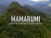
The Mama Rumi trail in Ecuador was traditionally a bootleg alcohol smuggling route. It was rediscovered and turned into an amazing mountain bike downhill adventure. It is a long track with a mix of technical and fast terrain. Most of it is a singletrail full of bobsled sections, called "culuncos", that offer great natural berms and ruts. It also has lots of sharp rocks in every size, slimy roots, and natural jumps. With only a couple climbs, Mama Rumi offers a beautiful aventure that crosses forests and plantations in 12 kilometers that descend from 2,800 meters above sea level to only 800. Now there's some jumps at the end, next to the small town of Telimbela, and a little pumptrack.

Traditionally Indigenous Territory

Recent Activity on Trail

Past Week
  • 0 rides
  •  
6 Months
  • 0 rides
  •  
All
  • 9 rides
  • Last: Nov 15, 2025
c1c2c3c4
January
February
March
April
May
June
July
August
September
October
November
December
update trails status or condition

Mama Rumi Trail Reports

statusdatedescription
Sep 27, 2024 @ 4:31pm
Sep 27, 2024
Sep 28, 2021 @ 8:00am
Sep 28, 2021
Jan 1, 2020 @ 7:28pm
Jan 1, 2020
Some trees down on the upper section. It is important that this track is the old version of the trail, the upper part until the big fire road is...
Nov 8, 2019 @ 5:58pm
Nov 8, 2019
The upper section might have some rain but the last section, after the open road, is bone dry and loose.
Nov 21, 2015 @ 3:42pm
Nov 21, 2015
more »
Status:
on Sep 27, 2024
Avg: 4.32 (3 votes)
Your vote: 0

view (189)
close
3D
Trail Conditions
  • Unknown
  • Snow Groomed
  • Snow Packed
  • Snow Covered
  • Snow Cover Partial
  • Freeze/thaw Cycle
  • Icy
  • Prevalent Mud
  • Wet
  • Variable
  • Ideal
  • Dry
  • Very Dry
Trail Flow (Ridden Direction)
Trailforks scans users ridelogs to determine the most popular direction each trail is ridden. A good flowing trail network will have most trails flowing in a single direction according to their intension.
The colour categories are based on what percentage of riders are riding a trail in its intended direction.
  • > 96%
  • > 90%
  • > 80%
  • > 70%
  • > 50%
  • < 50%
  • bi-directional trail
  • no data
Trail Last Ridden
Trailforks scans ridelogs to determine the last time a trail was ridden.
  • < 2 days
  • < 1 week
  • < 2 weeks
  • < 1 month
  • < 6 months
  • > 6 months
Trail Ridden Direction
The intended direction a trail should be ridden.
  • Downhill Only
  • Downhill Primary
  • Both Directions
  • Uphill Primary
  • Uphill Only
  • One Direction
Contribute Details
Colors indicate trail is missing specified detail.
  • Description
  • Photos
  • Description & Photos
  • Videos
Trail Popularity ?
Trailforks scans ridelogs to determine which trails are ridden the most in the last 9 months. Trails are compared with nearby trails in the same city region with a possible 25 colour shades. Think of this as a heatmap, more rides = more kinetic energy = warmer colors.
  • most popular
  • popular
  • less popular
  • not popular
ATV/ORV/OHV Filter
Max Vehicle Width
inches
US Cell Coverage
Legend
cell carrier legend

Radar Time
Activity Recordings
Trailforks uses anonymized public activity data. ?
Activity Recordings
Trailforks uses anonymized public activity data. ?
Personal Heatmap
Activity Types
all / none
Options
2
Date range month
Winter Trails
Warning A routing network for winter maps does not exist. Selecting trails using the winter trails layer has been disabled.
Missing Trails
Most Popular
Least Popular
Trails are colored based on popularity. The more popular a trail is, the more red. Less popular trails trend towards green.
Jump Magnitude Heatmap
Heatmap of where riders jump on trails. Zoom in to see individual jumps, click circles to view jump details.
BC Backroad Status

Service Road Atlas is a free to use, community-driven service for viewing and creating reports on the numerous back-country service roads around B.C. and Alberta.

map legend
Slope Aspect
Direction the slope faces
Flat N NE E SE S SW W NW
Trails Deemphasized
Trails are shown in grey.
disable
Only show trails with no bike usage.
Enable
Suggested Layers
Based on selected activity type

    Save the current map location and zoom level as your default home location whenever this page is loaded.

    Save
        Directions to mama-rumi trailhead (-1.652290, -79.108060)

        Photos

        75 more »
        113 |
        Jan 25, 2023 @ 7:39am
        Jan 25, 2023
        131 |
        Feb 19, 2020 @ 7:52pm
        Feb 19, 2020
        140 |
        Feb 19, 2020 @ 7:52pm
        Feb 19, 2020
        259 |
        Nov 8, 2019 @ 10:13am
        Nov 8, 2019

        Videos

        7 more »
        MAMARUMI - Un Sendero Preinca
        6:23 | 1621 | Oct 12, 2015 , Guaranda
        MAMA RUMI 2014 - VIDEO OFFICIAL ᴴᴰ
        774 | Oct 7, 2015 , Guaranda
        PROMO MAMA RUMI 2013
        615 | Oct 7, 2015 , Guaranda
        Downhill Mama Rumi
        1149 | Oct 7, 2015 , Guaranda

        1 Review & Comments


        We hope you've been enjoying Trailforks!

        Create a FREE account to view trail comments and much more.

        • By Paking MTBECUADOR & contributors
        • #23611 - 8,317 views

        Frequently Asked Questions About Mama Rumi

        Where is Mama Rumi located?
        Mama Rumi is located in Guaranda, Ecuador. It is part of the Guaranda trail network. The trailhead is located at coordinates -1.65229, -79.10806.
        How hard is Mama Rumi?
        Mama Rumi is rated as Double Black Diamond difficulty. The physical rating is Hard. The average grade is 17.701%.
        What is the elevation gain for Mama Rumi?
        Mama Rumi has 110 m of elevation gain. The trail has 2,065 m of elevation descent. The elevation ranges from 938 m to 2,892 m.
        Is Mama Rumi a point to point trail?
        Mama Rumi is not a point to point trail. The direction is Downhill Primary. The trail type is singletrack.

        Hit the Trail

        Open in App

        Get this trail on your phone instantly.
        open trail in app

        Download Trail

        Save to wishlist, Garmin & download.
        save the trail

        Find Related Routes

        Find routes and users activities that include this trail.
        find routes for this trail

        You must enter a description before submitting.