more stats
1.2 miles
Distance
-481 ft
Descent
00:11:06
Avg time
-481 ft
Altitude change
6,765 ft
Altitude min
7,245 ft
Altitude max
7,245 ft
Altitude start
6,765 ft
Altitude end
-7.5%
Grade
-24.7%
Grade max
-1.2%
Grade min
1 mile
Distance down
00:11:06
Avg time

Mamane Details

  • Activities
    • Mountain Bike
    • Hike
    • Trail Running
  • Riding Area
    Kula Forest Reserve
    Kula, Hawaii
  • Difficulty Rating
  • Local Popularity
    95 in Mountain Biking [+]
    • 5 in Trail Running
    • 70 in Hiking
  • Global Ranking
    #35623 in Mountain Biking [+]
    • #41584 in Hiking
  • Trail Type
    Singletrack
  • Bike Type
    DH, AM, XC
  • Direction
    Both Directions
    Popular Direction Shown
  • Climb Difficulty
    Blue
  • Physical Rating
    Hard
  • Dogs Allowed
    Yes
  • eBike Allowed
  • Ride in Rain
    Yes
  • Land Owner

The upper end is access via the Waipoli doubletrack to Skyline. It beings in low shrubs and grass slopes with lots of whoops and turns. The fun factor is high with plenty of opportunities to catch air.

The middle section of the trail transitions to a bit more technical riding with some loose cobble and small drops. The tree cover also changes and you'll find yourself riding through big bushy pine trees.

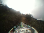
The lower reaches are the most technical with extended sections of rocks and boulders. The forest is perhaps the most beautiful with tall trees and small pockets of meadows. Unless you hit the trail early in the morning, you'll also find yourself riding through the mist.

Local Trail Association
Traditionally Indigenous Territory

Recent Activity on Trail

Past Week
  • 0 rides
  •  
6 Months
  • 8 rides
  • 19 miles avg distance
All
  • 65 rides
  • Last: Jan 6, 2026
c1c2c3c4
January
February
March
April
May
June
July
August
September
October
November
December
update trails status or condition

Mamane Trail Reports

statusdatedescription
Jul 28, 2023 @ 4:43am
Jul 28, 2023
A bit over grown in spots. Some thorns sticking out into the trail in a few areas so watch out. They can sang your clothes or skin.
Apr 10, 2023 @ 4:45pm
Apr 10, 2023
reporter
Jan 31, 2023 @ 1:48am
Jan 31, 2023
reporter Latest update from DLNR is end of March 2023 re-opening.
Jun 29, 2022 @ 7:46am
Jun 29, 2022
reporter Latest update is possible October 1, 2022 opening. Work has begun on road repairs. Recently riders who have been riding up Waipoli to access the...
Mar 3, 2022 @ 4:17pm
Mar 3, 2022
reporter Latest update from the State Forestry department is likely to stay closed until the end of 2022. Suggest contacting Maui DLNR office and...
more »
Status:
on Jul 28, 2023
Avg: 4.16 (8 votes)
Your vote: 0

view (336)
close
3D
Trail Conditions
  • Unknown
  • Snow Groomed
  • Snow Packed
  • Snow Covered
  • Snow Cover Partial
  • Freeze/thaw Cycle
  • Icy
  • Prevalent Mud
  • Wet
  • Variable
  • Ideal
  • Dry
  • Very Dry
Trail Flow (Ridden Direction)
Trailforks scans users ridelogs to determine the most popular direction each trail is ridden. A good flowing trail network will have most trails flowing in a single direction according to their intension.
The colour categories are based on what percentage of riders are riding a trail in its intended direction.
  • > 96%
  • > 90%
  • > 80%
  • > 70%
  • > 50%
  • < 50%
  • bi-directional trail
  • no data
Trail Last Ridden
Trailforks scans ridelogs to determine the last time a trail was ridden.
  • < 2 days
  • < 1 week
  • < 2 weeks
  • < 1 month
  • < 6 months
  • > 6 months
Trail Ridden Direction
The intended direction a trail should be ridden.
  • Downhill Only
  • Downhill Primary
  • Both Directions
  • Uphill Primary
  • Uphill Only
  • One Direction
Contribute Details
Colors indicate trail is missing specified detail.
  • Description
  • Photos
  • Description & Photos
  • Videos
Trail Popularity ?
Trailforks scans ridelogs to determine which trails are ridden the most in the last 9 months. Trails are compared with nearby trails in the same city region with a possible 25 colour shades. Think of this as a heatmap, more rides = more kinetic energy = warmer colors.
  • most popular
  • popular
  • less popular
  • not popular
ATV/ORV/OHV Filter
Max Vehicle Width
inches
US Cell Coverage
Legend
cell carrier legend

Radar Time
Activity Recordings
Trailforks uses anonymized public activity data. ?
Activity Recordings
Trailforks uses anonymized public activity data. ?
Personal Heatmap
Activity Types
all / none
Options
2
Date range month
Winter Trails
Warning A routing network for winter maps does not exist. Selecting trails using the winter trails layer has been disabled.
Missing Trails
Most Popular
Least Popular
Trails are colored based on popularity. The more popular a trail is, the more red. Less popular trails trend towards green.
Jump Magnitude Heatmap
Heatmap of where riders jump on trails. Zoom in to see individual jumps, click circles to view jump details.
BC Backroad Status

Service Road Atlas is a free to use, community-driven service for viewing and creating reports on the numerous back-country service roads around B.C. and Alberta.

map legend
Slope Aspect
Direction the slope faces
Flat N NE E SE S SW W NW
Trails Deemphasized
Trails are shown in grey.
disable
Only show trails with no bike usage.
Enable
Suggested Layers
Based on selected activity type

    Save the current map location and zoom level as your default home location whenever this page is loaded.

    Save
        Directions to mamane trailhead (20.679090, -156.318420)

        Photos

        41 more »
        192 |
        Mar 15, 2020 @ 11:14am
        Mar 15, 2020
        194 |
        Feb 23, 2019 @ 9:19am
        Feb 23, 2019
        187 |
        Feb 23, 2019 @ 9:19am
        Feb 23, 2019
        288 |
        Sep 15, 2016 @ 3:49pm
        Sep 15, 2016

        Videos

        1 more »
        mamane trail maui.hawaii
        4:29 | 586 | Nov 26, 2010 , Kula

        2 Reviews & Comments


        We hope you've been enjoying Trailforks!

        Create a FREE account to view trail comments and much more.

        • By Anthonyfonzi & contributors
        • #49808 - 3,692 views

        Frequently Asked Questions About Mamane

        Where is Mamane located?
        Mamane is located in Kula Forest Reserve, Kula, Hawaii, United States. It is part of the Kula Forest Reserve trail network. The trailhead is located at coordinates 20.67909, -156.31842.
        How hard is Mamane?
        Mamane is rated as Blue difficulty. The physical rating is Hard. The average grade is 7.5%. The climb difficulty is rated Blue.
        What is the elevation gain for Mamane?
        The trail has 481 ft of elevation descent. The elevation ranges from 6,765 ft to 7,245 ft.
        Is Mamane a point to point trail?
        Mamane is not a point to point trail. The direction is Both Directions. The trail type is singletrack.

        Hit the Trail

        Open in App

        Get this trail on your phone instantly.
        open trail in app

        Download Trail

        Save to wishlist, Garmin & download.
        save the trail

        Find Related Routes

        Find routes and users activities that include this trail.
        find routes for this trail

        You must enter a description before submitting.