more stats
4.0 miles
Distance
1,475 ft
Climb
-85 ft
Descent
00:53:57
Avg time
1,391 ft
Altitude change
1,098 ft
Altitude min
2,493 ft
Altitude max
1,103 ft
Altitude start
2,493 ft
Altitude end
6.6%
Grade
-7.9%
Grade max
42.8%
Grade min
3 miles
Distance climb
2,697 ft
Distance down
794 ft
Distance flat
00:53:57
Avg time

Manana Trail Details

  • Activities
    • Mountain Bike
    • Hike
    • Trail Running
  • Riding Area
    Pearl City
    , Hawaii
  • Difficulty Rating
  • Voted Difficulty
    Proline (1 vote)
  • Local Popularity
    85 in Mountain Biking [+]
    • 70 in Trail Running
    • 60 in Hiking
  • Global Ranking
    #57574 in Mountain Biking [+]
    • #30187 in Hiking
  • Hiking SAC Scale
    T2 Mountain Hiking
  • Trail Type
    Singletrack
  • Direction
    Both Directions
    Popular In Reverse
  • Climb Difficulty
    Black Diamond
  • Physical Rating
    Hard
  • Dogs Allowed
    Yes

Manana Trail is a fun there and back again ride. One way it runs about 2.75 miles giving you a solid 5.5 mile ride.

The trail itself is fairly diverse, ranging from paved road, jeep road, single track, roots, and grassy fields. The views are beautiful.

After passing the entrance gate to the trail you will ride up a paved road that eventually turns into a dirt road. This part of the trail is wide and you'll be able to ride side by side others. Eventually it transforms from a jeep road into more of hiking trail. Get ready to work, there are some big climbs ahead. Did I mention the roots? These big climbs are often packed full of pretty large roots.

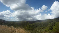
Eventually you will hit a little sign that shows a hiker and points left, you will want to take this. This will take you out of the trees and onto more of a ridge line single track. If you see signs that say to wear bright colors so you don't get shot by hunters, you are going the right way..... There are some wooden steps to navigate followed by a steady climb up the ridge. The trail at this point offers some beautiful views of O'ahu. This single track portion of the trail has tall grass on both sides and few trees giving it a completely different feel than the lower half. Keep heading up the ridge past the covered picnic table to complete the upward part of the trail.

Manana trail has some sections that are fairly steep and technical both up and down. Be sure to get off and walk your bike if you feel uncomfortable. Also the trail isn't always marked that well. Looking at the gps above you can see that it runs mostly straight up into the mountains, any trails that seem to sharply veer off to the right or left will most likely take you off the main trail.

Overall I really enjoy Manana Trail. It's a diverse, challenging but fun uphill climb with a rewarding and fast downhill.

source: MTB Hawaii
Access Info

Trail Google directions: https://goo.gl/maps/1PPnd

Local Trail Association
Traditionally Indigenous Territory

Recent Activity on Trail

Past Week
  • 0 rides
  •  
6 Months
  • 0 rides
  •  
All
  • 28 rides
  • Last: Jun 22, 2026
c1c2c3c4
January
February
March
April
May
June
July
August
September
October
November
December
update trails status or condition

Manana Trail Trail Reports

statusdatedescription
Dec 26, 2021 @ 3:42pm
Dec 26, 2021
Washout making trail very narrow
Feb 13, 2021 @ 11:29am
Feb 13, 2021
HEADS UP.. The narrow land bridge after the first plateau has a large chunk that eroded away. What was skinny and sorta sketch is even more...
Jul 2, 2020 @ 9:49pm
Jul 2, 2020
Jun 8, 2020 @ 11:43pm
Jun 8, 2020
Jun 8, 2020 @ 11:43pm
Jun 8, 2020
Dry most areas. Every afternoon the rain seems to come out of the valley and make the trail a little moist. It usually drys out fairly quickly....
more »
Status:
on Dec 26, 2021
Prevalent Mud
Avg: 3.99 (3 votes)
Your vote: 0

view (210)
close
3D
Trail Conditions
  • Unknown
  • Snow Groomed
  • Snow Packed
  • Snow Covered
  • Snow Cover Partial
  • Freeze/thaw Cycle
  • Icy
  • Prevalent Mud
  • Wet
  • Variable
  • Ideal
  • Dry
  • Very Dry
Trail Flow (Ridden Direction)
Trailforks scans users ridelogs to determine the most popular direction each trail is ridden. A good flowing trail network will have most trails flowing in a single direction according to their intension.
The colour categories are based on what percentage of riders are riding a trail in its intended direction.
  • > 96%
  • > 90%
  • > 80%
  • > 70%
  • > 50%
  • < 50%
  • bi-directional trail
  • no data
Trail Last Ridden
Trailforks scans ridelogs to determine the last time a trail was ridden.
  • < 2 days
  • < 1 week
  • < 2 weeks
  • < 1 month
  • < 6 months
  • > 6 months
Trail Ridden Direction
The intended direction a trail should be ridden.
  • Downhill Only
  • Downhill Primary
  • Both Directions
  • Uphill Primary
  • Uphill Only
  • One Direction
Contribute Details
Colors indicate trail is missing specified detail.
  • Description
  • Photos
  • Description & Photos
  • Videos
Trail Popularity ?
Trailforks scans ridelogs to determine which trails are ridden the most in the last 9 months. Trails are compared with nearby trails in the same city region with a possible 25 colour shades. Think of this as a heatmap, more rides = more kinetic energy = warmer colors.
  • most popular
  • popular
  • less popular
  • not popular
ATV/ORV/OHV Filter
Max Vehicle Width
inches
US Cell Coverage
Legend
cell carrier legend

Radar Time
Activity Recordings
Trailforks uses anonymized public activity data. ?
Activity Recordings
Trailforks uses anonymized public activity data. ?
Personal Heatmap
Activity Types
all / none
Options
2
Date range month
Winter Trails
Warning A routing network for winter maps does not exist. Selecting trails using the winter trails layer has been disabled.
Missing Trails
Most Popular
Least Popular
Trails are colored based on popularity. The more popular a trail is, the more red. Less popular trails trend towards green.
Jump Magnitude Heatmap
Heatmap of where riders jump on trails. Zoom in to see individual jumps, click circles to view jump details.
BC Backroad Status

Service Road Atlas is a free to use, community-driven service for viewing and creating reports on the numerous back-country service roads around B.C. and Alberta.

map legend
Slope Aspect
Direction the slope faces
Flat N NE E SE S SW W NW
Trails Deemphasized
Trails are shown in grey.
disable
Only show trails with no bike usage.
Enable
Suggested Layers
Based on selected activity type

    Save the current map location and zoom level as your default home location whenever this page is loaded.

    Save
        Directions to manana-trail trailhead (21.434710, -157.927690)

        Photos

        57 more »
        265 |
        Mar 13, 2021 @ 7:45am
        Mar 13, 2021
        210 |
        Mar 13, 2021 @ 7:45am
        Mar 13, 2021
        116 |
        Jan 19, 2021 @ 7:31pm
        Jan 19, 2021
        159 |
        Jan 19, 2021 @ 7:31pm
        Jan 19, 2021

        Videos

        2 more »
        Mountain Biking Manana Ridge Trail On Oahu!!!!!!
        10:45 | 654 | Jan 7, 2022 , Pearl City
        Hawaii mountain biking, Manana Trail
        4:38 | 1165 | Mar 17, 2013 , Pearl City

        4 Reviews & Comments


        We hope you've been enjoying Trailforks!

        Create a FREE account to view trail comments and much more.

        • By canadakaTF Pro Trailforks & contributors
        • #28150 - 5,942 views

        Frequently Asked Questions About Manana Trail

        Where is Manana Trail located?
        Manana Trail is located in Pearl City, Hawaii, United States. It is part of the Pearl City trail network. The trailhead is located at coordinates 21.43471, -157.92769.
        How hard is Manana Trail?
        Manana Trail is rated as Black Diamond difficulty. The physical rating is Hard. The average grade is 6.6%. The climb difficulty is rated Black Diamond.
        What is the elevation gain for Manana Trail?
        Manana Trail has 1,475 ft of elevation gain. The trail has 85 ft of elevation descent. The elevation ranges from 1,098 ft to 2,493 ft.
        Is Manana Trail a point to point trail?
        Manana Trail is not a point to point trail. The direction is Both Directions. The trail type is singletrack.

        Hit the Trail

        Open in App

        Get this trail on your phone instantly.
        open trail in app

        Download Trail

        Save to wishlist, Garmin & download.
        save the trail

        Find Related Routes

        Find routes and users activities that include this trail.
        find routes for this trail

        You must enter a description before submitting.