more stats
2,126 ft
Distance
-414 ft
Descent
1,243 ft
High Point
-414 ft
Altitude change
829 ft
Altitude min
1,243 ft
Altitude start
830 ft
Altitude end
-19.5%
Grade
-39.3%
Grade max
-6.2%
Grade min
2,126 ft
Distance down

Mango Loco Details

  • Activities
    • Mountain Bike
    • E-Bike
  • Riding Area
  • Difficulty Rating
  • Voted Difficulty
    Red (4 votes)
  • Local Popularity
    90 in Mountain Biking [+]
    • 95 in E-Biking
  • Global Ranking
    #145572 in Mountain Biking [+]
    • #16518 in E-Biking
  • Trail Type
    Singletrack
  • Bike Type
    AM
  • Direction
    Downhill Only
    Popular Direction Shown
  • Trail Visibility
    Always easy to follow
  • Dogs Allowed
    Yes
  • eBike Allowed
    Yes up to Class 1
  • TTFs on Trail
    Berm, Drop, Jump, Gap Jump

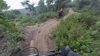
Trail amb força flow. Peraltes i salts. Tots ténen chicken accessible. La majoria son de dificultat blava però hi ha un en concret que és de nivell força més alt però no cal saltar-lo.

Trail con mucho flow. Peraltes y saltos. Todos tienen chicken accessible. La mayoría son de dificultad azul pero hay uno en concreto que el nivel es bastante más elevado pero no hace falta saltarlo.

Recent Activity on Trail

Past Week
  • 0 rides
  •  
6 Months
  • 36 rides
  • 13 miles avg distance
All
  • 86 rides
  • Last: Jun 10, 2026
c1c2c3c4
January
February
March
April
May
June
July
August
September
October
November
December
update trails status or condition

Mango Loco Trail Reports

statusdatedescription
Apr 15, 2026 @ 7:35pm (Europe/Madrid)
Apr 15, 2026
Muy chula...saltitos... dropetes...ojo el drop alargado que se esta descolgando el filo...
Apr 10, 2026 @ 3:40pm (Europe/Madrid)
Apr 10, 2026
Mar 8, 2026 @ 8:30pm (Europe/Madrid)
Mar 8, 2026
reporter
Mar 7, 2026 @ 8:48am (Europe/Madrid)
Mar 6, 2026
Una mica trillada al principi, necessita manteniment
Jan 8, 2026 @ 10:06am (Europe/Madrid)
Jan 8, 2026
more »
Status:
on Apr 15, 2026
Dry
Avg: 4.39 (4 votes)
Your vote: 0

view (1,108)
close
3D
Trail Conditions
  • Unknown
  • Snow Groomed
  • Snow Packed
  • Snow Covered
  • Snow Cover Partial
  • Freeze/thaw Cycle
  • Icy
  • Prevalent Mud
  • Wet
  • Variable
  • Ideal
  • Dry
  • Very Dry
Trail Flow (Ridden Direction)
Trailforks scans users ridelogs to determine the most popular direction each trail is ridden. A good flowing trail network will have most trails flowing in a single direction according to their intension.
The colour categories are based on what percentage of riders are riding a trail in its intended direction.
  • > 96%
  • > 90%
  • > 80%
  • > 70%
  • > 50%
  • < 50%
  • bi-directional trail
  • no data
Trail Last Ridden
Trailforks scans ridelogs to determine the last time a trail was ridden.
  • < 2 days
  • < 1 week
  • < 2 weeks
  • < 1 month
  • < 6 months
  • > 6 months
Trail Ridden Direction
The intended direction a trail should be ridden.
  • Downhill Only
  • Downhill Primary
  • Both Directions
  • Uphill Primary
  • Uphill Only
  • One Direction
Contribute Details
Colors indicate trail is missing specified detail.
  • Description
  • Photos
  • Description & Photos
  • Videos
Trail Popularity ?
Trailforks scans ridelogs to determine which trails are ridden the most in the last 9 months. Trails are compared with nearby trails in the same city region with a possible 25 colour shades. Think of this as a heatmap, more rides = more kinetic energy = warmer colors.
  • most popular
  • popular
  • less popular
  • not popular
ATV/ORV/OHV Filter
Max Vehicle Width
inches
US Cell Coverage
Legend
cell carrier legend

Radar Time
Activity Recordings
Trailforks uses anonymized public activity data. ?
Activity Recordings
Trailforks uses anonymized public activity data. ?
Personal Heatmap
Activity Types
all / none
Options
2
Date range month
Winter Trails
Warning A routing network for winter maps does not exist. Selecting trails using the winter trails layer has been disabled.
Missing Trails
Most Popular
Least Popular
Trails are colored based on popularity. The more popular a trail is, the more red. Less popular trails trend towards green.
Jump Magnitude Heatmap
Heatmap of where riders jump on trails. Zoom in to see individual jumps, click circles to view jump details.
BC Backroad Status

Service Road Atlas is a free to use, community-driven service for viewing and creating reports on the numerous back-country service roads around B.C. and Alberta.

map legend
Slope Aspect
Direction the slope faces
Flat N NE E SE S SW W NW
Trails Deemphasized
Trails are shown in grey.
disable
Only show trails with no bike usage.
Enable
Suggested Layers
Based on selected activity type

    Save the current map location and zoom level as your default home location whenever this page is loaded.

    Save
        Directions to mango-loco trailhead (41.579140, 2.447390)

        Photos

        0 more »
        17 |
        Apr 15, 2026 @ 10:35am
        Apr 15, 2026
        13 |
        Apr 15, 2026 @ 10:35am
        Apr 15, 2026
        18 |
        Apr 15, 2026 @ 10:35am
        Apr 15, 2026
        20 |
        Apr 15, 2026 @ 10:35am
        Apr 15, 2026

        Videos

        1 more »
        Mango loco - Mataró
        2:19 | 282 | Apr 30, 2025 , Mataró

        Routes with this trail

        15 miles 3,943 ft 17 Loop
        Ruta endurera espaectacular cerca de Mataró encadenando las mejores trialeras (azules) de la zona.

        1 Review & Comments


        We hope you've been enjoying Trailforks!

        Create a FREE account to view trail comments and much more.

        Nearby Trails

        • By snaker4TF Pro TFSPAIN & contributors
        • #831408 - 851 views

        Frequently Asked Questions About Mango Loco

        Where is Mango Loco located?
        Mango Loco is located in Mataró, Spain. It is part of the Mataró trail network. The trailhead is located at coordinates 41.57914, 2.44739.
        How hard is Mango Loco?
        Mango Loco is rated as Blue difficulty. The average grade is 19.5%.
        What is the elevation gain for Mango Loco?
        The trail has 126 m of elevation descent. The elevation ranges from 253 m to 379 m.
        Is Mango Loco a point to point trail?
        Yes, Mango Loco is a point to point trail. The direction is Downhill Only. The trail type is singletrack.

        Hit the Trail

        Open in App

        Get this trail on your phone instantly.
        open trail in app

        Download Trail

        Save to wishlist, Garmin & download.
        save the trail

        Find Related Routes

        Find routes and users activities that include this trail.
        find routes for this trail

        You must enter a description before submitting.