more stats
6.4 miles
Distance
2,279 ft
Climb
-2,241 ft
Descent
05:11:13
Avg time
37 ft
Altitude change
4,850 ft
Altitude min
6,967 ft
Altitude max
4,850 ft
Altitude start
4,888 ft
Altitude end
0.1%
Grade
-40.2%
Grade max
69.4%
Grade min
3 miles
Distance climb
3 miles
Distance down
1,752 ft
Distance flat
05:11:13
Avg time

Maple Pass Trail Details

  • Activities
    • Hike
    • Trail Running
  • Ref Number
    #740
  • AKA
    Heather-Maple Pass Loop
  • Difficulty Rating
  • Global Ranking
    #357486 in Hiking [+]
    • #348241 in Trail Running
  • Hiking SAC Scale
    T2 Mountain Hiking
  • Trail Type
    Singletrack
  • Direction
    Both Directions
    Popular In Reverse
  • Alpine Trail
    Yes
  • Dogs Allowed
    Yes
  • eBike Allowed
  • Land Owner
    USFS/NPS

If ever there was a hike to satisfy all a hiker's desires, this one comes as close as any. A loop hike with many fabulous changing faces throughout the seasons, Heather-Maple Pass features ridgelines blanketed in wildflowers in summer, lakes ringed with golden larches in fall, and before the highway closes for the season, a dramatic place to experience early winter’s snows.

The trail heading counter-clockwise leaves immediately from the parking lot, heading uphill moderately through second-growth forest and dappled sunlight. After about 1.25 miles, a trail branches left to Lake Ann, a jewel cradled in a talus bowl, a glacial cirque created in eons past. The detour is a relatively flat 0.6 miles round trip and well-worth it. Stopping by the shore of Lake Ann affords you a view of the pass that you're headed to. Be sure to note the forces of glaciation and landslides which have created it and the large island within it.

Back on the main trail, you'll traverse above Lake Ann, traversing through swathes of wildflowers before reaching Heather Pass, about three-quarters of a mile past the Lake Ann turnoff. From Heather Pass there are social trails which meander through meadows to the north. These are routes that cross-country hikers and climbers use to visit Lewis and Wing Lakes, Black Peak, and beyond. But views from the trail itself are stunning enough.

Now redirect yourself, following the trail as it heads left on the ridgeline and continue upward towards Maple Pass. Note that this section of the trail crosses a steep hillside that can retain snow until late in the season.

Gaining the ridge, the edge of the North Cascades National Park is evident by prominent park signs. Wander, gaze, luxuriate, and thrill at the views, both at your feet and off to the horizon. Watch for ptarmigans and their young roosts. Nearby mountains include Corteo, Frisco, Goode, Stiletto, Black Peak and many more. A bit more distant is the stately Liberty Bell group beckoning. And then past that, a sea of peaks stretches out in every direction as far as your imagination can hike.

All too soon this glorious loop starts switch-backing downwards. Luckily, the views continue unabated. The trail picks up speed through the forest. The last 2.5 miles drops about 1700 feet on pretty sound tread. When the trail finally pops out onto a paved ADA-accessible path, turn left and you’ve got just one half mile to your car.

If you decide to hike the trail heading clockwise, set out from the southern end of the parking lot, along a paved trail which travels the trail that also leads to Rainy Lake, a nice detour or alternate destination for those with a group of varying hiking abilities. One-half mile along this trail, arrive at a fork and take the right branch, turning uphill. Continuing straight would take you another 0.6 miles to Rainy Lake.

From the fork, hike uphill along your first switchback. The way is quite gradual, but gains elevation steadily through avalanche paths and mature woods. Continue climbing as you switchback a few times through hillsides awash in penstemon, Indian paintbrush, monkeyflower, sitka valerian and more, until you arrive in Maple Pass, with its stunning views of Black Peak and North Cascades National Park. Your descent is more gradual, sweeping along the loop as it arcs east, down to the junction with Lake Ann.

If you've got time, take the detour for Lake Ann. If not, the parking lot is a little more than a mile further on.

One can debate the merits of hiking this loop either clockwise or counter-clockwise. Going clockwise, one reaps the benefit of getting the steep part of the trail out of the way early in the day and a more gradual descent at day’s end, while a counter-clockwise hike offers ever more dramatic views of Black Peak and the North Cascades National Park as you climb to the pass. But at the end of the day, you will be in awe of the area no matter which way you elect to go.

Access Info

Going counter-clockwise the trail leaves directly from the Rainy Pass trailhead. Going clockwise, the trail is accessed after going a short while on the Rainy Lake Trail.

Local Trail Association

Recent Activity on Trail

Past Week
  • 0 rides
  •  
6 Months
  • 0 rides
  •  
All
  • 95 rides
  •  
c1c2c3c4
January
February
March
April
May
June
July
August
September
October
November
December
update trails status or condition

Maple Pass Trail Trail Reports

statusdatedescription
Oct 6, 2024 @ 9:25am
Oct 6, 2024
Jun 28, 2023 @ 3:27pm
Jun 28, 2023
Some patches of snow and mud, but easily done without microspikes. Poles may be helpful but not needed
Jun 27, 2021 @ 11:41am
Jun 27, 2021
50% snow travel; in the heat wave it was soft and easy to kick steps in. Used spikes. Slid down sections over Rainy so counterclockwise way...
Oct 17, 2020 @ 7:01pm
Oct 17, 2020
Snow covering the whole trail. crampon's and poles required.
more »
Status:
on Oct 6, 2024
Ideal
Avg: 5 (2 votes)
Your vote: 0

view (502)
close
3D
Trail Conditions
  • Unknown
  • Snow Groomed
  • Snow Packed
  • Snow Covered
  • Snow Cover Partial
  • Freeze/thaw Cycle
  • Icy
  • Prevalent Mud
  • Wet
  • Variable
  • Ideal
  • Dry
  • Very Dry
Trail Flow (Ridden Direction)
Trailforks scans users ridelogs to determine the most popular direction each trail is ridden. A good flowing trail network will have most trails flowing in a single direction according to their intension.
The colour categories are based on what percentage of riders are riding a trail in its intended direction.
  • > 96%
  • > 90%
  • > 80%
  • > 70%
  • > 50%
  • < 50%
  • bi-directional trail
  • no data
Trail Last Ridden
Trailforks scans ridelogs to determine the last time a trail was ridden.
  • < 2 days
  • < 1 week
  • < 2 weeks
  • < 1 month
  • < 6 months
  • > 6 months
Trail Ridden Direction
The intended direction a trail should be ridden.
  • Downhill Only
  • Downhill Primary
  • Both Directions
  • Uphill Primary
  • Uphill Only
  • One Direction
Contribute Details
Colors indicate trail is missing specified detail.
  • Description
  • Photos
  • Description & Photos
  • Videos
Trail Popularity ?
Trailforks scans ridelogs to determine which trails are ridden the most in the last 9 months. Trails are compared with nearby trails in the same city region with a possible 25 colour shades. Think of this as a heatmap, more rides = more kinetic energy = warmer colors.
  • most popular
  • popular
  • less popular
  • not popular
ATV/ORV/OHV Filter
Max Vehicle Width
inches
US Cell Coverage
Legend
cell carrier legend

Radar Time
Activity Recordings
Trailforks uses anonymized public activity data. ?
Activity Recordings
Trailforks uses anonymized public activity data. ?
Personal Heatmap
Activity Types
all / none
Options
2
Date range month
Winter Trails
Warning A routing network for winter maps does not exist. Selecting trails using the winter trails layer has been disabled.
Missing Trails
Most Popular
Least Popular
Trails are colored based on popularity. The more popular a trail is, the more red. Less popular trails trend towards green.
Jump Magnitude Heatmap
Heatmap of where riders jump on trails. Zoom in to see individual jumps, click circles to view jump details.
BC Backroad Status

Service Road Atlas is a free to use, community-driven service for viewing and creating reports on the numerous back-country service roads around B.C. and Alberta.

map legend
Slope Aspect
Direction the slope faces
Flat N NE E SE S SW W NW
Trails Deemphasized
Trails are shown in grey.
disable
Only show trails with no bike usage.
Enable
Suggested Layers
Based on selected activity type

    Save the current map location and zoom level as your default home location whenever this page is loaded.

    Save
        Directions to maple-pass-trail trailhead (48.510520, -120.734770)

        Photos

        5 more »
        38 |
        Aug 28, 2022 @ 8:18pm
        Aug 28, 2022
        46 |
        Aug 28, 2022 @ 8:18pm
        Aug 28, 2022
        59 |
        Oct 14, 2021 @ 3:11pm
        Oct 14, 2021
        70 |
        Sep 22, 2021 @ 5:00pm
        Sep 22, 2021

        Videos

        no videos have been added for Maple Pass Trail yet, add a video.

        Articles

        Winthrop, WA: Lake Ann, Heather Pass, Maple Pass, Rainy Lake Loop
        Sep 19, 2013 from backpacker.com
        Think of this hike as a five-star gourmet meal for the price of a cheeseburger, the crescendo will leave you utterly speechless, yet leave you...

        Routes with this trail

        7 miles 2,289 ft 1 Loop
        Breathtaking mountain views on this very popular loop hike. Choose your loop direction wisely: get the...
        9 miles 2,398 ft 4 Loop
        Think of this hike as a five-star gourmet meal for the price of a cheeseburger... Hike to both Maple and...

        Reviews / Comments

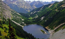
        No reviews yet, be the first to write a review or ask a question.
        Use trail reports to comment on trail conditions.


        We hope you've been enjoying Trailforks!

        Create a FREE account to view trail comments and much more.

        Nearby Trails

        • By k-wTF Pro & contributors
        • #329853 - 1,429 views

        Frequently Asked Questions About Maple Pass Trail

        Where is Maple Pass Trail located?
        Maple Pass Trail is located in Washington, United States. The trailhead is located at coordinates 48.51052, -120.73477.
        How hard is Maple Pass Trail?
        Maple Pass Trail is rated as Blue difficulty. The average grade is 0.1%.
        What is the elevation gain for Maple Pass Trail?
        Maple Pass Trail has 2,279 ft of elevation gain. The trail has 2,241 ft of elevation descent. The elevation ranges from 4,850 ft to 6,967 ft.
        Is Maple Pass Trail a point to point trail?
        Maple Pass Trail is not a point to point trail. The direction is Both Directions. The trail type is singletrack.

        Hit the Trail

        Open in App

        Get this trail on your phone instantly.
        open trail in app

        Download Trail

        Save to wishlist, Garmin & download.
        save the trail

        Find Related Routes

        Find routes and users activities that include this trail.
        find routes for this trail

        You must enter a description before submitting.