more stats
4,541 ft
Distance
537 ft
Climb
-28 ft
Descent
00:16:01
Avg time
509 ft
Altitude change
315 ft
Altitude min
823 ft
Altitude max
315 ft
Altitude start
823 ft
Altitude end
11.2%
Grade
-12.2%
Grade max
46.6%
Grade min
3,917 ft
Distance climb
577 ft
Distance down
46 ft
Distance flat
00:16:01
Avg time

Marmolera Details

  • Activities
    • Mountain Bike
    • E-Bike
    • Horse
    • Hike
    • Trail Running
  • Riding Area
    Castellón Ciudad
    Castellon de La Plana
  • Difficulty Rating
  • Local Popularity
    95 in Mountain Biking [+]
    • 100 in E-Biking
    • 5 in Trail Running
    • 5 in Hiking
  • Global Ranking
    #55674 in Mountain Biking [+]
    • #1009 in E-Biking
    • #75531 in Trail Running
    • #170692 in Hiking
  • Trail Exposure
    High Risk
  • Trail Type
    Singletrack
  • Bike Type
    AM, XC
  • Direction
    Both Directions[+]
    Popular Direction Shown
    • Both Directions for Horseback
  • Climb Difficulty
    Blue
  • Physical Rating
    Hard
  • Trail Visibility
    Always easy to follow
  • Dogs Allowed
    Yes
  • eBike Allowed
    Yes up to Class 1

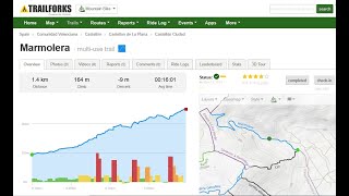
Camino Mas de la Figuera más comúnmente conocido como la "Marmolera" al ser un antiguo acceso a una cantera de mármol. Ojo porque se pasa por un terreno privado. Ahora mismo es un sendero que en algunos sitios se cierra. La parte alta se pasa por encima de la cantera de mármol y hay que ir con mucho cuidado. Si tropiezas y caes te matas.

Recent Activity on Trail

Past Week
  • 0 rides
  •  
6 Months
  • 11 rides
  • 40.6 km avg distance
All
  • 103 rides
  • Last: May 29, 2026
c1c2c3c4
January
February
March
April
May
June
July
August
September
October
November
December
update trails status or condition

Marmolera Trail Reports

statusdatedescription
May 11, 2026 @ 7:32am (Europe/Madrid)
May 10, 2026
ojo garrapas
Apr 23, 2026 @ 8:37am (Europe/Andorra)
Apr 22, 2026
reporter Como siempre, en subida no te deja un respiro de lo rota que está.
Mar 17, 2026 @ 9:30am (Europe/Andorra)
Mar 17, 2026
reporter
Sep 25, 2025 @ 8:45am (Europe/Andorra)
Sep 24, 2025
reporter Está creciendo la vegetación y el estado del camino va a peor
Jun 23, 2025 @ 8:04am
Jun 23, 2025
reporter
more »
Status:
on May 11, 2026
Avg: 4.13 (2 votes)
Your vote: 0

view (618)
close
3D
Trail Conditions
  • Unknown
  • Snow Groomed
  • Snow Packed
  • Snow Covered
  • Snow Cover Partial
  • Freeze/thaw Cycle
  • Icy
  • Prevalent Mud
  • Wet
  • Variable
  • Ideal
  • Dry
  • Very Dry
Trail Flow (Ridden Direction)
Trailforks scans users ridelogs to determine the most popular direction each trail is ridden. A good flowing trail network will have most trails flowing in a single direction according to their intension.
The colour categories are based on what percentage of riders are riding a trail in its intended direction.
  • > 96%
  • > 90%
  • > 80%
  • > 70%
  • > 50%
  • < 50%
  • bi-directional trail
  • no data
Trail Last Ridden
Trailforks scans ridelogs to determine the last time a trail was ridden.
  • < 2 days
  • < 1 week
  • < 2 weeks
  • < 1 month
  • < 6 months
  • > 6 months
Trail Ridden Direction
The intended direction a trail should be ridden.
  • Downhill Only
  • Downhill Primary
  • Both Directions
  • Uphill Primary
  • Uphill Only
  • One Direction
Contribute Details
Colors indicate trail is missing specified detail.
  • Description
  • Photos
  • Description & Photos
  • Videos
Trail Popularity ?
Trailforks scans ridelogs to determine which trails are ridden the most in the last 9 months. Trails are compared with nearby trails in the same city region with a possible 25 colour shades. Think of this as a heatmap, more rides = more kinetic energy = warmer colors.
  • most popular
  • popular
  • less popular
  • not popular
ATV/ORV/OHV Filter
Max Vehicle Width
inches
US Cell Coverage
Legend
cell carrier legend

Radar Time
Activity Recordings
Trailforks uses anonymized public activity data. ?
Activity Recordings
Trailforks uses anonymized public activity data. ?
Personal Heatmap
Activity Types
all / none
Options
2
Date range month
Winter Trails
Warning A routing network for winter maps does not exist. Selecting trails using the winter trails layer has been disabled.
Missing Trails
Most Popular
Least Popular
Trails are colored based on popularity. The more popular a trail is, the more red. Less popular trails trend towards green.
Jump Magnitude Heatmap
Heatmap of where riders jump on trails. Zoom in to see individual jumps, click circles to view jump details.
BC Backroad Status

Service Road Atlas is a free to use, community-driven service for viewing and creating reports on the numerous back-country service roads around B.C. and Alberta.

map legend
Slope Aspect
Direction the slope faces
Flat N NE E SE S SW W NW
Trails Deemphasized
Trails are shown in grey.
disable
Only show trails with no bike usage.
Enable
Suggested Layers
Based on selected activity type

    Save the current map location and zoom level as your default home location whenever this page is loaded.

    Save
        Directions to marmolera trailhead (40.032690, -0.034230)

        Photos

        1 more »
        49 |
        May 23, 2023 @ 9:14am
        May 23, 2023

        Videos

        1 more »
        Marmolera
        4:57 | 57 | Mar 31, 2025 , Castellon de La Plana

        Routes with this trail

        28 miles 2,878 ft 6 Loop
        Ruta de mucho empujar la bici

        Reviews / Comments

        No reviews yet, be the first to write a review or ask a question.
        Use trail reports to comment on trail conditions.


        We hope you've been enjoying Trailforks!

        Create a FREE account to view trail comments and much more.

        • By rafafernandezcsTF Pro & contributors
        • #337163 - 449 views

        Frequently Asked Questions About Marmolera

        Where is Marmolera located?
        Marmolera is located in Castellón Ciudad, Castellon de La Plana, Spain. It is part of the Castellón Ciudad trail network. The trailhead is located at coordinates 40.03269, -0.03423.
        How hard is Marmolera?
        Marmolera is rated as Blue difficulty. The physical rating is Hard. The average grade is 11.2%. The climb difficulty is rated Blue.
        What is the elevation gain for Marmolera?
        Marmolera has 537 ft of elevation gain. The trail has 28 ft of elevation descent. The elevation ranges from 315 ft to 823 ft.
        Is Marmolera a point to point trail?
        Marmolera is not a point to point trail. The direction is Both Directions. The trail type is singletrack.

        Hit the Trail

        Open in App

        Get this trail on your phone instantly.
        open trail in app

        Download Trail

        Save to wishlist, Garmin & download.
        save the trail

        Find Related Routes

        Find routes and users activities that include this trail.
        find routes for this trail

        You must enter a description before submitting.