more stats
7.0 miles
Distance
182 ft
Climb
-4,769 ft
Descent
01:33:49
Avg time
-4,590 ft
Altitude change
765 ft
Altitude min
5,355 ft
Altitude max
5,355 ft
Altitude start
764 ft
Altitude end
-12.4%
Grade
-61.7%
Grade max
22.1%
Grade min
3,369 ft
Distance climb
6 miles
Distance down
1,713 ft
Distance flat
01:33:49
Avg time

Matadown Trail Details

  • Activities
    • Mountain Bike
    • E-Bike
    • Hike
    • Trail Running
  • Riding Area
  • Difficulty Rating
  • Voted Difficulty
    Red (9 votes)
  • Local Popularity
    55 in Mountain Biking [+]
    • 55 in E-Biking
    • 5 in Trail Running
    • 95 in Hiking
  • Global Ranking
    #13688 in Mountain Biking [+]
    • #3810 in E-Biking
    • #110900 in Trail Running
    • #106955 in Hiking
  • Trail Type
    Singletrack
  • Bike Type
    DH, AM, XC
  • Direction
    Downhill Primary
    Popular Direction Shown
  • Climb Difficulty
    Blue
  • Physical Rating
    Hard
  • Dogs Allowed
    Yes
  • eBike Allowed
    Yes up to Class 1
  • TTFs on Trail
    Drop, Rock Garden
  • Land Owner
    Italia

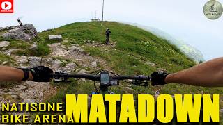
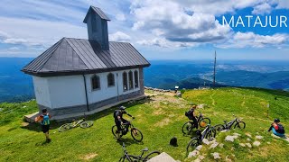
The King of Trails of Natisone Bike Arena
A long 12 km natural trail from the edge of Mt. Matajur to the valley bottom near Sorzento's village after 1.450 mt of negative descent.
Voted by readers of a most-known bike website as one of the best trails in whole Europe. The trail is very eclectic and begins with a steepy and rocky part that push to the limit both bike and rider's strenght. After the fields before Glevizza's pass we jump into the middle part reaaaally flow with some technical passages and counterslopes. The final part after the short uphill after S. Canziano's pass leads into two nice rockgardens and a small bike-park area with easy jumps and drops before the St. Nicolò Church.
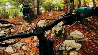
The terrain is clayey so not recommended in wet condition.

The Matadown Race will be held on 09.08.2020 - check infos on Matadown page in Facebook.

ASD Machete Team

Local Trail Association

Recent Activity on Trail

Past Week
  • 0 rides
  •  
6 Months
  • 6 rides
  • 44.5 km avg distance
All
  • 63 rides
  • Last: Jun 13, 2026
c1c2c3c4
January
February
March
April
May
June
July
August
September
October
November
December
update trails status or condition

Matadown Trail Trail Reports

statusdatedescription
Nov 9, 2025 @ 8:34am (Europe/Rome)
Nov 8, 2025
Top is peefect. Lots of leaves in the middle section, few places where it is slippery as the ground is not fully drying up anymore. Fun but...
Oct 18, 2025 @ 10:57am (Europe/Rome)
Oct 18, 2025
Running great apart from the big ruts in the grass at the top.
Jul 7, 2025 @ 11:55am
Jul 7, 2025
Good condition, no riding issues. After summit there are some meadow trail parts which are eroded with flowing rain water, but in reasonable speed...
May 24, 2025 @ 10:49am
May 24, 2025
Nov 4, 2024 @ 9:22am
Nov 4, 2024
Trail is in good condition. Lot of leaves in the lower parts.
more »
Status:
on Nov 9, 2025
Variable
Avg: 4.62 (28 votes)
Your vote: 0

view (366)
close
3D
Trail Conditions
  • Unknown
  • Snow Groomed
  • Snow Packed
  • Snow Covered
  • Snow Cover Partial
  • Freeze/thaw Cycle
  • Icy
  • Prevalent Mud
  • Wet
  • Variable
  • Ideal
  • Dry
  • Very Dry
Trail Flow (Ridden Direction)
Trailforks scans users ridelogs to determine the most popular direction each trail is ridden. A good flowing trail network will have most trails flowing in a single direction according to their intension.
The colour categories are based on what percentage of riders are riding a trail in its intended direction.
  • > 96%
  • > 90%
  • > 80%
  • > 70%
  • > 50%
  • < 50%
  • bi-directional trail
  • no data
Trail Last Ridden
Trailforks scans ridelogs to determine the last time a trail was ridden.
  • < 2 days
  • < 1 week
  • < 2 weeks
  • < 1 month
  • < 6 months
  • > 6 months
Trail Ridden Direction
The intended direction a trail should be ridden.
  • Downhill Only
  • Downhill Primary
  • Both Directions
  • Uphill Primary
  • Uphill Only
  • One Direction
Contribute Details
Colors indicate trail is missing specified detail.
  • Description
  • Photos
  • Description & Photos
  • Videos
Trail Popularity ?
Trailforks scans ridelogs to determine which trails are ridden the most in the last 9 months. Trails are compared with nearby trails in the same city region with a possible 25 colour shades. Think of this as a heatmap, more rides = more kinetic energy = warmer colors.
  • most popular
  • popular
  • less popular
  • not popular
ATV/ORV/OHV Filter
Max Vehicle Width
inches
US Cell Coverage
Legend
cell carrier legend

Radar Time
Activity Recordings
Trailforks uses anonymized public activity data. ?
Activity Recordings
Trailforks uses anonymized public activity data. ?
Personal Heatmap
Activity Types
all / none
Options
2
Date range month
Winter Trails
Warning A routing network for winter maps does not exist. Selecting trails using the winter trails layer has been disabled.
Missing Trails
Most Popular
Least Popular
Trails are colored based on popularity. The more popular a trail is, the more red. Less popular trails trend towards green.
Jump Magnitude Heatmap
Heatmap of where riders jump on trails. Zoom in to see individual jumps, click circles to view jump details.
BC Backroad Status

Service Road Atlas is a free to use, community-driven service for viewing and creating reports on the numerous back-country service roads around B.C. and Alberta.

map legend
Slope Aspect
Direction the slope faces
Flat N NE E SE S SW W NW
Trails Deemphasized
Trails are shown in grey.
disable
Only show trails with no bike usage.
Enable
Suggested Layers
Based on selected activity type

    Save the current map location and zoom level as your default home location whenever this page is loaded.

    Save
        Directions to matadown-trail trailhead (46.212190, 13.529510)

        Photos

        44 more »
        392 |
        May 6, 2023 @ 2:15pm
        May 6, 2023
        365 |
        Aug 16, 2022 @ 5:35am
        Aug 16, 2022
        286 |
        Aug 16, 2022 @ 5:35am
        Aug 16, 2022
        309 |
        Aug 16, 2022 @ 5:35am
        Aug 16, 2022

        Videos

        8 more »
        Top trail Matadown v Natisone Bike Arena to je...
        43:21 | 124 | Jan 29, 2026 , San Pietro Al Natisone
        Matajur Matadown Trail (2016-2018)
        15:44 | 1198 | Feb 21, 2022 , San Pietro Al Natisone
        Matadown half (DH) marathon - Matajur trail...
        15:49 | 615 | Aug 13, 2021 , San Pietro Al Natisone
        Matadown 2021
        43:08 | 1183 | Jun 27, 2021 , San Pietro Al Natisone

        Routes with this trail

        5.0 21 miles 5,182 ft 1 Point to Point
        Tough route that starts in Pulfero (170 mt altitude) and reach the Matajur mountain (1.650 mt. altitude)...

        10 Reviews & Comments


        We hope you've been enjoying Trailforks!

        Create a FREE account to view trail comments and much more.

        • By maxmisdarisTF Pro MGNR & contributors
        • #82239 - 19,171 views

        Frequently Asked Questions About Matadown Trail

        Where is Matadown Trail located?
        Matadown Trail is located in Natisone Bike Arena (S.Pietro/Pulfero), San Pietro Al Natisone, Italy. It is part of the Natisone Bike Arena (S.Pietro/Pulfero) trail network. The trailhead is located at coordinates 46.21219, 13.52951.
        How hard is Matadown Trail?
        Matadown Trail is rated as Red difficulty. The physical rating is Hard. The average grade is 12.4%. The climb difficulty is rated Blue.
        What is the elevation gain for Matadown Trail?
        Matadown Trail has 182 ft of elevation gain. The trail has 4,769 ft of elevation descent. The elevation ranges from 765 ft to 5,355 ft.
        Is Matadown Trail a point to point trail?
        Matadown Trail is not a point to point trail. The direction is Downhill Primary. The trail type is singletrack.

        Hit the Trail

        Open in App

        Get this trail on your phone instantly.
        open trail in app

        Download Trail

        Save to wishlist, Garmin & download.
        save the trail

        Find Related Routes

        Find routes and users activities that include this trail.
        find routes for this trail

        You must enter a description before submitting.