more stats
4,258 ft
Distance
121 ft
Climb
-19 ft
Descent
00:05:06
Avg time
102 ft
Altitude change
5,190 ft
Altitude min
5,305 ft
Altitude max
5,204 ft
Altitude start
5,305 ft
Altitude end
2.39%
Grade
-14.006%
Grade max
31.913%
Grade min
2,468 ft
Distance climb
1,040 ft
Distance down
750 ft
Distance flat
00:05:06
Avg time

Maxwell (A Trail) Details

  • Activities
    • Mountain Bike
    • Hike
    • Trail Running
  • Riding Area
    Maxwell Natural Area
    Fort Collins, Colorado
  • Difficulty Rating
  • Local Popularity
    100 in Mountain Biking [+]
    • 100 in Trail Running
    • 95 in Hiking
  • Global Ranking
    #37514 in Mountain Biking [+]
    • #2238 in Trail Running
    • #22897 in Hiking
  • Trail Type
    Singletrack
  • Bike Type
    AM, XC
  • Direction
    Both Directions
  • Climb Difficulty
    Blue
  • Physical Rating
    Moderate
  • Season
    Year Round
  • Dogs Allowed
    Yes
  • Land Owner
    City of Fort Collins

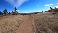
Maxwell is a multi-use non-directional trail. It consists of dry hard pack clay and rocks. It can be ridden by any skill level and is offers higher difficulty line choices for those wanting to push it. It is very popular and therefore best ridden weekdays or early in the mornings when there are less hikers, dog walkers and trail runners.

Trail Supporters
  • Overland Mountain Bike Club
    Sponsor
Local Trail Association

Recent Activity on Trail

Past Week
  • 8 rides
  • 10 miles average
6 Months
  • 135 rides
  • 10 miles avg distance
All
  • 1,074 rides
  • Last: Jun 20, 2026
c1c2c3c4
January
February
March
April
May
June
July
August
September
October
November
December
update trails status or condition

Maxwell (A Trail) Trail Reports

statusdatedescription
Oct 23, 2025 @ 3:28pm (America/Denver)
Oct 23, 2025
Trail was dry, good amount of loose, granular dirt on sections.
Jun 29, 2025 @ 6:10am
Jun 29, 2025
No snakes this morning and trail is in good condition. Needs some water diversion about 3/4 of the way up (deep cracks in the middle of the trail).
May 4, 2025 @ 11:08am
May 4, 2025
Oct 23, 2024 @ 5:16pm
Oct 23, 2024
Oct 9, 2024 @ 5:20pm
Oct 9, 2024
more »
Status:
on Oct 23, 2025
Very Dry
Avg: 3.99 (3 votes)
Your vote: 0

view (13,136)
close
3D
Trail Conditions
  • Unknown
  • Snow Groomed
  • Snow Packed
  • Snow Covered
  • Snow Cover Partial
  • Freeze/thaw Cycle
  • Icy
  • Prevalent Mud
  • Wet
  • Variable
  • Ideal
  • Dry
  • Very Dry
Trail Flow (Ridden Direction)
Trailforks scans users ridelogs to determine the most popular direction each trail is ridden. A good flowing trail network will have most trails flowing in a single direction according to their intension.
The colour categories are based on what percentage of riders are riding a trail in its intended direction.
  • > 96%
  • > 90%
  • > 80%
  • > 70%
  • > 50%
  • < 50%
  • bi-directional trail
  • no data
Trail Last Ridden
Trailforks scans ridelogs to determine the last time a trail was ridden.
  • < 2 days
  • < 1 week
  • < 2 weeks
  • < 1 month
  • < 6 months
  • > 6 months
Trail Ridden Direction
The intended direction a trail should be ridden.
  • Downhill Only
  • Downhill Primary
  • Both Directions
  • Uphill Primary
  • Uphill Only
  • One Direction
Contribute Details
Colors indicate trail is missing specified detail.
  • Description
  • Photos
  • Description & Photos
  • Videos
Trail Popularity ?
Trailforks scans ridelogs to determine which trails are ridden the most in the last 9 months. Trails are compared with nearby trails in the same city region with a possible 25 colour shades. Think of this as a heatmap, more rides = more kinetic energy = warmer colors.
  • most popular
  • popular
  • less popular
  • not popular
ATV/ORV/OHV Filter
Max Vehicle Width
inches
US Cell Coverage
Legend
cell carrier legend

Radar Time
Activity Recordings
Trailforks uses anonymized public activity data. ?
Activity Recordings
Trailforks uses anonymized public activity data. ?
Personal Heatmap
Activity Types
all / none
Options
2
Date range month
Winter Trails
Warning A routing network for winter maps does not exist. Selecting trails using the winter trails layer has been disabled.
Missing Trails
Most Popular
Least Popular
Trails are colored based on popularity. The more popular a trail is, the more red. Less popular trails trend towards green.
Jump Magnitude Heatmap
Heatmap of where riders jump on trails. Zoom in to see individual jumps, click circles to view jump details.
BC Backroad Status

Service Road Atlas is a free to use, community-driven service for viewing and creating reports on the numerous back-country service roads around B.C. and Alberta.

map legend
Slope Aspect
Direction the slope faces
Flat N NE E SE S SW W NW
Trails Deemphasized
Trails are shown in grey.
disable
Only show trails with no bike usage.
Enable
Suggested Layers
Based on selected activity type

    Save the current map location and zoom level as your default home location whenever this page is loaded.

    Save
        Directions to maxwell-a-trail trailhead (40.556570, -105.143820)

        Photos

        1 more »
        70 |
        Dec 2, 2021 @ 3:46pm
        Dec 2, 2021

        Videos

        2 more »
        CO - Maxwell (A Trail)
        79 | Jun 13, 2025 , Fort Collins
        Maxwell with the new hero7 black
        2:23 | 145 | Oct 3, 2018 , Fort Collins

        Routes with this trail

        10 miles 919 ft 9
        A fun ride around the foothills that includes a bit of flow and a bit of tech.
        11 miles 1,564 ft 20
        This loop takes in many of the multiple trails that make up the Foothills system. Easily accessible from...

        1 Review & Comments


        We hope you've been enjoying Trailforks!

        Create a FREE account to view trail comments and much more.

        • By toddTF Pro Trailforks & contributors
        • #13631 - 2,707 views

        Frequently Asked Questions About Maxwell (A Trail)

        Where is Maxwell (A Trail) located?
        Maxwell (A Trail) is located in Maxwell Natural Area, Fort Collins, Colorado, United States. It is part of the Maxwell Natural Area trail network. The trailhead is located at coordinates 40.55657, -105.14382.
        How hard is Maxwell (A Trail)?
        Maxwell (A Trail) is rated as Green difficulty. The physical rating is Moderate. The average grade is 2.39%. The climb difficulty is rated Blue.
        What is the elevation gain for Maxwell (A Trail)?
        Maxwell (A Trail) has 121 ft of elevation gain. The trail has 19 ft of elevation descent. The elevation ranges from 5,190 ft to 5,305 ft.
        Is Maxwell (A Trail) a point to point trail?
        Maxwell (A Trail) is not a point to point trail. The direction is Both Directions. The trail type is singletrack.

        Hit the Trail

        Open in App

        Get this trail on your phone instantly.
        open trail in app

        Download Trail

        Save to wishlist, Garmin & download.
        save the trail

        Find Related Routes

        Find routes and users activities that include this trail.
        find routes for this trail

        You must enter a description before submitting.