more stats
10.6 miles
Distance
920 ft
Climb
-931 ft
Descent
01:18:49
Avg time
-10 ft
Altitude change
2,698 ft
Altitude min
3,295 ft
Altitude max
2,709 ft
Altitude start
2,700 ft
Altitude end
-28%
Grade max
39.3%
Grade min
4 miles
Distance climb
4 miles
Distance down
2 miles
Distance flat
01:18:49
Avg time

Trail Details

  • Activities
    • Mountain Bike
    • E-Bike
    • Gravel Bike
    • Adaptive Bike
    • Hike
    • Trail Running
  • Riding Area
    East Kootenays
    British Columbia
  • Difficulty Rating
  • Global Ranking
    #156629 in Mountain Biking [+]
    • #181995 in E-Biking
    • #348438 in Trail Running
    • #357722 in Hiking
  • Trail Type
    Gravel Path
  • Bike Type
    AM, XC, Gravel, Adaptive MTB
  • Direction
    Both Directions
  • Climb Difficulty
    Green
  • Physical Rating
    Easy
  • Season
    Apr-Oct
  • Dogs Allowed
    Yes
  • eBike Allowed
    Yes up to Class 1
  • Year Opened
    2016
  • Land Owner

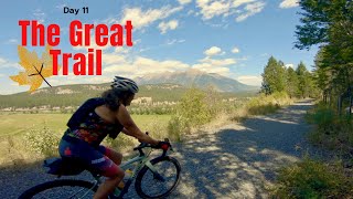
Considered to be the most fun part of the Chief Isadore Trail, this graveled cycling trail is a enjoyable ride from families up to seniors. Designed to not exceed 5% grades for the most part, this x-country route has plenty of turns, SBs, and is highlighted by 4 aluminum bridges over bubbling creeks.

Access Info

Pritchard Road Trailhead, Ha Ha Road Trail Head

Trail Supporters
Local Trail Association
Traditionally Indigenous Territory

Recent Activity on Trail

Past Week
  • 0 rides
  •  
6 Months
  • 9 rides
  • 31 miles avg distance
All
  • 163 rides
  • Last: Jun 14, 2026
c1c2c3c4
January
February
March
April
May
June
July
August
September
October
November
December
update trails status or condition

Mayook Section... Trail Reports

Status:
on Apr 25, 2026
Avg: 3.99 (6 votes)
Your vote: 0

view (1,040)
close
3D
Trail Conditions
  • Unknown
  • Snow Groomed
  • Snow Packed
  • Snow Covered
  • Snow Cover Partial
  • Freeze/thaw Cycle
  • Icy
  • Prevalent Mud
  • Wet
  • Variable
  • Ideal
  • Dry
  • Very Dry
Trail Flow (Ridden Direction)
Trailforks scans users ridelogs to determine the most popular direction each trail is ridden. A good flowing trail network will have most trails flowing in a single direction according to their intension.
The colour categories are based on what percentage of riders are riding a trail in its intended direction.
  • > 96%
  • > 90%
  • > 80%
  • > 70%
  • > 50%
  • < 50%
  • bi-directional trail
  • no data
Trail Last Ridden
Trailforks scans ridelogs to determine the last time a trail was ridden.
  • < 2 days
  • < 1 week
  • < 2 weeks
  • < 1 month
  • < 6 months
  • > 6 months
Trail Ridden Direction
The intended direction a trail should be ridden.
  • Downhill Only
  • Downhill Primary
  • Both Directions
  • Uphill Primary
  • Uphill Only
  • One Direction
Contribute Details
Colors indicate trail is missing specified detail.
  • Description
  • Photos
  • Description & Photos
  • Videos
Trail Popularity ?
Trailforks scans ridelogs to determine which trails are ridden the most in the last 9 months. Trails are compared with nearby trails in the same city region with a possible 25 colour shades. Think of this as a heatmap, more rides = more kinetic energy = warmer colors.
  • most popular
  • popular
  • less popular
  • not popular
ATV/ORV/OHV Filter
Max Vehicle Width
inches
US Cell Coverage
Legend
cell carrier legend

Radar Time
Activity Recordings
Trailforks uses anonymized public activity data. ?
Activity Recordings
Trailforks uses anonymized public activity data. ?
Personal Heatmap
Activity Types
all / none
Options
2
Date range month
Winter Trails
Warning A routing network for winter maps does not exist. Selecting trails using the winter trails layer has been disabled.
Missing Trails
Most Popular
Least Popular
Trails are colored based on popularity. The more popular a trail is, the more red. Less popular trails trend towards green.
Jump Magnitude Heatmap
Heatmap of where riders jump on trails. Zoom in to see individual jumps, click circles to view jump details.
BC Backroad Status

Service Road Atlas is a free to use, community-driven service for viewing and creating reports on the numerous back-country service roads around B.C. and Alberta.

map legend
Slope Aspect
Direction the slope faces
Flat N NE E SE S SW W NW
Trails Deemphasized
Trails are shown in grey.
disable
Only show trails with no bike usage.
Enable
Suggested Layers
Based on selected activity type

    Save the current map location and zoom level as your default home location whenever this page is loaded.

    Save
        Directions to mayook-section-chief-isadore-trail trailhead (49.518000, -115.602490)

        Photos

        24 more »
        138 |
        Feb 1, 2021 @ 4:27pm
        Feb 1, 2021
        213 |
        May 20, 2020 @ 5:06pm
        May 20, 2020
        195 |
        May 20, 2020 @ 5:04pm
        May 20, 2020
        201 |
        May 20, 2020 @ 5:01pm
        May 20, 2020

        Videos

        1 more »
        1,000 kilometre gravel cycling adventure - The...
        20:12 | 370 | Apr 5, 2022 , My City

        Routes with this trail

        4.5 27 miles 1,129 ft 12 Point to Point
        .The trail is maintained and supported by Trails BC/Rockies Region The Chief Isadore Trail from Cranbrook...
        2.9 27 miles 1,129 ft 12 Point to Point
        .The trail is maintained and supported by Trails BC/Rockies Region The Chief Isadore Trail from Cranbrook...
        41 miles 1,913 ft 6
        Cranbrook the Koocanusa Campsite. Follows the TransCanada Trail. (Chief Isadore Trail) moderate fitness...

        4 Reviews & Comments


        We hope you've been enjoying Trailforks!

        Create a FREE account to view trail comments and much more.

        • By TrailsBCTF Pro TrailsBC & contributors
        • #68523 - 6,831 views

        Frequently Asked Questions About Mayook Section (Chief Isadore Trail)

        Where is Mayook Section (Chief Isadore Trail) located?
        Mayook Section (Chief Isadore Trail) is located in East Kootenays, British Columbia, Canada. It is part of the East Kootenays trail network. The trailhead is located at coordinates 49.518, -115.60249.
        How hard is Mayook Section (Chief Isadore Trail)?
        Mayook Section (Chief Isadore Trail) is rated as Green difficulty. The physical rating is Easy. The climb difficulty is rated Green.
        What is the elevation gain for Mayook Section (Chief Isadore Trail)?
        Mayook Section (Chief Isadore Trail) has 920 ft of elevation gain. The trail has 931 ft of elevation descent. The elevation ranges from 2,698 ft to 3,295 ft.
        Is Mayook Section (Chief Isadore Trail) a point to point trail?
        Mayook Section (Chief Isadore Trail) is not a point to point trail. The direction is Both Directions. The trail type is gravel path.

        Hit the Trail

        Open in App

        Get this trail on your phone instantly.
        open trail in app

        Download Trail

        Save to wishlist, Garmin & download.
        save the trail

        Find Related Routes

        Find routes and users activities that include this trail.
        find routes for this trail

        You must enter a description before submitting.