more stats
1.4 miles
Distance
160 ft
Climb
-201 ft
Descent
00:12:20
Avg time
-43 ft
Altitude change
1,142 ft
Altitude min
1,215 ft
Altitude max
1,190 ft
Altitude start
1,148 ft
Altitude end
-0.6%
Grade
-33.8%
Grade max
22%
Grade min
1,949 ft
Distance climb
3,202 ft
Distance down
2,195 ft
Distance flat
00:12:20
Avg time

Medusa Details

  • Activities
    • Mountain Bike
    • E-Bike
    • Gravel Bike
    • Hike
    • Trail Running
  • Riding Area
    Slaughter Pen Trails
    Bentonville, Arkansas
  • Difficulty Rating
  • Voted Difficulty
    Blue (4 votes)
  • Local Popularity
    65 in Mountain Biking [+]
    • 65 in E-Biking
    • 65 in Trail Running
    • 30 in Hiking
  • Global Ranking
    #1242 in Mountain Biking [+]
    • #2225 in E-Biking
    • #84701 in Trail Running
    • #107921 in Hiking
  • Hiking SAC Scale
    T3 Demanding Mountain Hiking
  • Trail Type
    Singletrack
  • Bike Type
    AM, XC, Fat, CX, Gravel
  • Direction
    Downhill Only[+]
    • Downhill Only for E-Biking
    • Downhill Only for Trail Running
    • Downhill Only for Hiking
    • Downhill Only for Gravel Biking
  • Climb Difficulty
    Blue
  • Physical Rating
    Easy
  • Trail Visibility
    Always easy to follow
  • Season
    Jan - Dec
  • Dogs Allowed
    Yes
  • eBike Allowed
    Yes up to Class 1
  • TTFs on Trail
    Bridge, Jump, Ladder Bridge, Log Ride, Rock Garden, Skinny

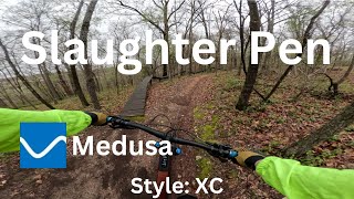
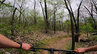
Medusa is part of the Slaughter Pen Trail system and is the highest on the hill so climbing is required to access the trail. The trails are wide and well marked.

Most of the trail is cross country type riding and many of the more difficult features have an alternate line. The trail starts at the the SE end with an optional elevated catwalk that is about 18-24" wide. The trail traverses the length of the hill and does merge briefly with Tatamagouche (stay on the uphill side to continue Medusa). A right turn at the northern end of the trail leads to the the Slaughter Pen DH Flow trail.

A "less experienced rider" hitting all the major features of Medusa would probably consider the trail a difficult black diamond, but seasoned riders will find it to be a good intermediate challenge. It is a great place to gain confidence and experience.

Local Trail Association

Recent Activity on Trail

Past Week
  • 12 rides
  • 12 miles average
6 Months
  • 237 rides
  • 14 miles avg distance
All
  • 1,628 rides
  • Last: Jun 18, 2026
c1c2c3c4
January
February
March
April
May
June
July
August
September
October
November
December
Status:
on Apr 1, 2026
Dry
Avg: 4.08 (18 votes)
Your vote: 0

view (11,217)
close
3D
Trail Conditions
  • Unknown
  • Snow Groomed
  • Snow Packed
  • Snow Covered
  • Snow Cover Partial
  • Freeze/thaw Cycle
  • Icy
  • Prevalent Mud
  • Wet
  • Variable
  • Ideal
  • Dry
  • Very Dry
Trail Flow (Ridden Direction)
Trailforks scans users ridelogs to determine the most popular direction each trail is ridden. A good flowing trail network will have most trails flowing in a single direction according to their intension.
The colour categories are based on what percentage of riders are riding a trail in its intended direction.
  • > 96%
  • > 90%
  • > 80%
  • > 70%
  • > 50%
  • < 50%
  • bi-directional trail
  • no data
Trail Last Ridden
Trailforks scans ridelogs to determine the last time a trail was ridden.
  • < 2 days
  • < 1 week
  • < 2 weeks
  • < 1 month
  • < 6 months
  • > 6 months
Trail Ridden Direction
The intended direction a trail should be ridden.
  • Downhill Only
  • Downhill Primary
  • Both Directions
  • Uphill Primary
  • Uphill Only
  • One Direction
Contribute Details
Colors indicate trail is missing specified detail.
  • Description
  • Photos
  • Description & Photos
  • Videos
Trail Popularity ?
Trailforks scans ridelogs to determine which trails are ridden the most in the last 9 months. Trails are compared with nearby trails in the same city region with a possible 25 colour shades. Think of this as a heatmap, more rides = more kinetic energy = warmer colors.
  • most popular
  • popular
  • less popular
  • not popular
ATV/ORV/OHV Filter
Max Vehicle Width
inches
US Cell Coverage
Legend
cell carrier legend

Radar Time
Activity Recordings
Trailforks uses anonymized public activity data. ?
Activity Recordings
Trailforks uses anonymized public activity data. ?
Personal Heatmap
Activity Types
all / none
Options
2
Date range month
Winter Trails
Warning A routing network for winter maps does not exist. Selecting trails using the winter trails layer has been disabled.
Missing Trails
Most Popular
Least Popular
Trails are colored based on popularity. The more popular a trail is, the more red. Less popular trails trend towards green.
Jump Magnitude Heatmap
Heatmap of where riders jump on trails. Zoom in to see individual jumps, click circles to view jump details.
BC Backroad Status

Service Road Atlas is a free to use, community-driven service for viewing and creating reports on the numerous back-country service roads around B.C. and Alberta.

map legend
Slope Aspect
Direction the slope faces
Flat N NE E SE S SW W NW
Trails Deemphasized
Trails are shown in grey.
disable
Only show trails with no bike usage.
Enable
Suggested Layers
Based on selected activity type

    Save the current map location and zoom level as your default home location whenever this page is loaded.

    Save
        Directions to medusa trailhead (36.410910, -94.214630)

        Photos

        38 more »
        44 |
        Mar 15, 2026 @ 1:16pm
        Mar 15, 2026
        46 |
        Mar 15, 2026 @ 1:14pm
        Mar 15, 2026
        54 |
        May 27, 2025 @ 7:28am
        May 27, 2025
        145 |
        Nov 4, 2023 @ 8:38pm
        Nov 4, 2023

        Videos

        3 more »
        Medusa - Slaughter Pen
        10:59 | 348 | May 31, 2024 , Bentonville
        Snaky Skinny Fail
        0:09 | 609 | Apr 29, 2021 , Bentonville
        A little bit of Slaughter Pen
        3:11 | 1012 | Nov 8, 2017 , Bentonville

        Routes with this trail

        5.0 138 miles 12,933 ft 95
        This is the route Payson McElveen posted on his strava for the Bentonville trail challenge 2021.
        5.0 154 miles 16,667 ft 120
        This is my plan for the 2021 Bentonville Trail Challenge.
        5.0 17 miles 1,986 ft 36 Loop
        This route hits most of my Slaughter Pen favorites.

        7 Reviews & Comments


        We hope you've been enjoying Trailforks!

        Create a FREE account to view trail comments and much more.

        Frequently Asked Questions About Medusa

        Where is Medusa located?
        Medusa is located in Slaughter Pen Trails, Bentonville, Arkansas, United States. It is part of the Slaughter Pen Trails trail network. The trailhead is located at coordinates 36.41091, -94.21463.
        How hard is Medusa?
        Medusa is rated as Blue difficulty. The physical rating is Easy. The average grade is 0.6%. The climb difficulty is rated Blue.
        What is the elevation gain for Medusa?
        Medusa has 160 ft of elevation gain. The trail has 201 ft of elevation descent. The elevation ranges from 1,142 ft to 1,215 ft.
        Is Medusa a point to point trail?
        Yes, Medusa is a point to point trail. The direction is Downhill Only. The trail type is singletrack.

        Hit the Trail

        Open in App

        Get this trail on your phone instantly.
        open trail in app

        Download Trail

        Save to wishlist, Garmin & download.
        save the trail

        Find Related Routes

        Find routes and users activities that include this trail.
        find routes for this trail

        You must enter a description before submitting.