more stats
2,808 ft
Distance
-284 ft
Descent
00:05:19
Avg time
-284 ft
Altitude change
3,225 ft
Altitude min
3,510 ft
Altitude max
3,510 ft
Altitude start
3,225 ft
Altitude end
-10.1%
Grade
-40.7%
Grade max
2,664 ft
Distance down
144 ft
Distance flat
00:05:19
Avg time

Mega Drive Details

  • Activities
    • Mountain Bike
    • Hike
    • Trail Running
  • Riding Area
    Macacos
    Nova Lima
  • Difficulty Rating
  • Local Popularity
    75 in Mountain Biking [+]
    • 5 in Trail Running
    • 5 in Hiking
  • Global Ranking
    #93237 in Mountain Biking [+]
    • #148528 in Trail Running
    • #142836 in Hiking
  • Hiking SAC Scale
    T2 Mountain Hiking
  • Trail Type
    Singletrack
  • Bike Type
    AM, XC
  • Direction
    Downhill Only
    Popular Direction Shown
  • Climb Difficulty
    Black Diamond
  • Physical Rating
    Moderate
  • Trail Visibility
    Sometimes hard to follow
  • Dogs Allowed
    Yes
  • TTFs on Trail
    Drop

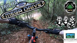
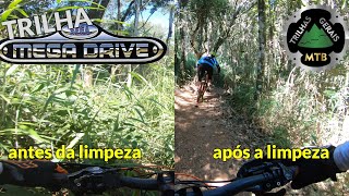
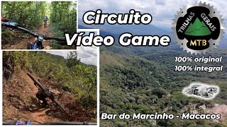
trilha paralela a estrada de acesso ao Bar do Marcinho. É muito comum ter troncos e mato dentro da trilha pois ela é dentro da mata. Trilha pouco usada

Access Info

Atenção: logo na entrada deve virar a direita. Se for reto vai para outra trilha até dentro do rio.

Local Trail Association

Recent Activity on Trail

Past Week
  • 0 rides
  •  
6 Months
  • 1 rides
  • 49 miles avg distance
All
  • 29 rides
  • Last: Jun 10, 2026
c1c2c3c4
January
February
March
April
May
June
July
August
September
October
November
December
update trails status or condition

Mega Drive Trail Reports

statusdatedescription
Sep 1, 2024 @ 7:34am
Sep 1, 2024
Muita terra solta devido ao tempo seco, mesmo assim a trilha está ótima.
Jul 28, 2024 @ 7:32am
Jul 28, 2024
Muito seca, bem prejudicada pelas motos.
Apr 3, 2023 @ 9:07am
Apr 3, 2023
Aug 14, 2021 @ 6:38am
Aug 14, 2021
Jul 25, 2020 @ 12:49pm
Jul 25, 2020
Trilha com trato para MTB, atualmente está 100% pedalável.
more »
Status:
on Sep 1, 2024
Dry
Avg: 4.13 (1 votes)
Your vote: 0

view (602)
close
3D
Trail Conditions
  • Unknown
  • Snow Groomed
  • Snow Packed
  • Snow Covered
  • Snow Cover Partial
  • Freeze/thaw Cycle
  • Icy
  • Prevalent Mud
  • Wet
  • Variable
  • Ideal
  • Dry
  • Very Dry
Trail Flow (Ridden Direction)
Trailforks scans users ridelogs to determine the most popular direction each trail is ridden. A good flowing trail network will have most trails flowing in a single direction according to their intension.
The colour categories are based on what percentage of riders are riding a trail in its intended direction.
  • > 96%
  • > 90%
  • > 80%
  • > 70%
  • > 50%
  • < 50%
  • bi-directional trail
  • no data
Trail Last Ridden
Trailforks scans ridelogs to determine the last time a trail was ridden.
  • < 2 days
  • < 1 week
  • < 2 weeks
  • < 1 month
  • < 6 months
  • > 6 months
Trail Ridden Direction
The intended direction a trail should be ridden.
  • Downhill Only
  • Downhill Primary
  • Both Directions
  • Uphill Primary
  • Uphill Only
  • One Direction
Contribute Details
Colors indicate trail is missing specified detail.
  • Description
  • Photos
  • Description & Photos
  • Videos
Trail Popularity ?
Trailforks scans ridelogs to determine which trails are ridden the most in the last 9 months. Trails are compared with nearby trails in the same city region with a possible 25 colour shades. Think of this as a heatmap, more rides = more kinetic energy = warmer colors.
  • most popular
  • popular
  • less popular
  • not popular
ATV/ORV/OHV Filter
Max Vehicle Width
inches
US Cell Coverage
Legend
cell carrier legend

Radar Time
Activity Recordings
Trailforks uses anonymized public activity data. ?
Activity Recordings
Trailforks uses anonymized public activity data. ?
Personal Heatmap
Activity Types
all / none
Options
2
Date range month
Winter Trails
Warning A routing network for winter maps does not exist. Selecting trails using the winter trails layer has been disabled.
Missing Trails
Most Popular
Least Popular
Trails are colored based on popularity. The more popular a trail is, the more red. Less popular trails trend towards green.
Jump Magnitude Heatmap
Heatmap of where riders jump on trails. Zoom in to see individual jumps, click circles to view jump details.
BC Backroad Status

Service Road Atlas is a free to use, community-driven service for viewing and creating reports on the numerous back-country service roads around B.C. and Alberta.

map legend
Slope Aspect
Direction the slope faces
Flat N NE E SE S SW W NW
Trails Deemphasized
Trails are shown in grey.
disable
Only show trails with no bike usage.
Enable
Suggested Layers
Based on selected activity type

    Save the current map location and zoom level as your default home location whenever this page is loaded.

    Save
        Directions to mega-drive trailhead (-20.034910, -43.943530)

        Photos

        1 more »
        39 |
        Jun 19, 2020 @ 8:45pm
        Jun 19, 2020

        Videos

        5 more »
        youtuber Mega Drive, Depois do Trato (Recém Limpa)....
        5:10 | 317 | Apr 14, 2021 , Nova Lima
        youtuber Mega Drive: Antes e Depois da Limpeza. Trilha...
        6:58 | 317 | May 17, 2020 , Nova Lima
        youtuber Bar do Marcinho: Circuito Vídeo Game e...
        47:12 | 54 | Dec 14, 2025 , Nova Lima
        Trilha Mega Drive
        3:33 | 22 | Sep 26, 2025 , Nova Lima

        Routes with this trail

        4,642 ft 278 ft 1 Loop
        Trilha de downhill e enduro em sentido único com inclinação acentuada. Múltiplos trechos técnicos com...

        Reviews / Comments

        No reviews yet, be the first to write a review or ask a question.
        Use trail reports to comment on trail conditions.


        We hope you've been enjoying Trailforks!

        Create a FREE account to view trail comments and much more.

        • By renatobaltarTF Pro WTFB & contributors
        • #279335 - 782 views

        Frequently Asked Questions About Mega Drive

        Where is Mega Drive located?
        Mega Drive is located in Macacos, Nova Lima, Brazil. It is part of the Macacos trail network. The trailhead is located at coordinates -20.03491, -43.94353.
        How hard is Mega Drive?
        Mega Drive is rated as Black Diamond difficulty. The physical rating is Moderate. The average grade is 10.1%. The climb difficulty is rated Black Diamond.
        What is the elevation gain for Mega Drive?
        The trail has 284 ft of elevation descent. The elevation ranges from 3,225 ft to 3,510 ft.
        Is Mega Drive a point to point trail?
        Yes, Mega Drive is a point to point trail. The direction is Downhill Only. The trail type is singletrack.

        Hit the Trail

        Open in App

        Get this trail on your phone instantly.
        open trail in app

        Download Trail

        Save to wishlist, Garmin & download.
        save the trail

        Find Related Routes

        Find routes and users activities that include this trail.
        find routes for this trail

        You must enter a description before submitting.