more stats
1,178 ft
Distance
-156 ft
Descent
00:06:10
Avg time
-156 ft
Altitude change
900 ft
Altitude min
1,055 ft
Altitude max
1,055 ft
Altitude start
899 ft
Altitude end
-13.2%
Grade
-35.7%
Grade max
0.9%
Grade min
994 ft
Distance down
184 ft
Distance flat
00:06:10
Avg time

Megalodon Details

  • Activities
    • Mountain Bike
  • Riding Area
    Camp Fortune
    Chelsea, Quebec
  • Difficulty Rating
  • Voted Difficulty
    Double Black Diamond (1 vote)
  • Local Popularity
    20 in Mountain Biking
  • Global Ranking
    #50732 in Mountain Biking
  • Trail Type
    Singletrack
  • Bike Type
    DH
  • eBike Allowed
  • TTFs on Trail
    Berm, Drop, Jump, Gap Jump, Rock Face, Rock Garden, Wallride
  • Land Owner
    Camp Fortune

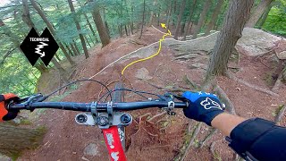
The hardest trail at Camp Fortune for hitting jumps Megalodon is the crown jewl of hits on the slope.
Starting with small jumps,gaps and drops. Then a skinny/hit and a large wallride. Followed by fast and flowy downhill afterwards. A must ride for daredevils

Bike Park

Local Trail Association

Recent Activity on Trail

Past Week
  • 0 rides
  •  
6 Months
  • 4 rides
  • 11 miles avg distance
All
  • 61 rides
  • Last: Jun 3, 2026
c1c2c3c4
January
February
March
April
May
June
July
August
September
October
November
December
update trails status or condition

Megalodon Trail Reports

Status:
on May 20, 2026
Avg: 3.99 (7 votes)
Your vote: 0

view (489)
close
3D
Trail Conditions
  • Unknown
  • Snow Groomed
  • Snow Packed
  • Snow Covered
  • Snow Cover Partial
  • Freeze/thaw Cycle
  • Icy
  • Prevalent Mud
  • Wet
  • Variable
  • Ideal
  • Dry
  • Very Dry
Trail Flow (Ridden Direction)
Trailforks scans users ridelogs to determine the most popular direction each trail is ridden. A good flowing trail network will have most trails flowing in a single direction according to their intension.
The colour categories are based on what percentage of riders are riding a trail in its intended direction.
  • > 96%
  • > 90%
  • > 80%
  • > 70%
  • > 50%
  • < 50%
  • bi-directional trail
  • no data
Trail Last Ridden
Trailforks scans ridelogs to determine the last time a trail was ridden.
  • < 2 days
  • < 1 week
  • < 2 weeks
  • < 1 month
  • < 6 months
  • > 6 months
Trail Ridden Direction
The intended direction a trail should be ridden.
  • Downhill Only
  • Downhill Primary
  • Both Directions
  • Uphill Primary
  • Uphill Only
  • One Direction
Contribute Details
Colors indicate trail is missing specified detail.
  • Description
  • Photos
  • Description & Photos
  • Videos
Trail Popularity ?
Trailforks scans ridelogs to determine which trails are ridden the most in the last 9 months. Trails are compared with nearby trails in the same city region with a possible 25 colour shades. Think of this as a heatmap, more rides = more kinetic energy = warmer colors.
  • most popular
  • popular
  • less popular
  • not popular
ATV/ORV/OHV Filter
Max Vehicle Width
inches
US Cell Coverage
Legend
cell carrier legend

Radar Time
Activity Recordings
Trailforks uses anonymized public activity data. ?
Activity Recordings
Trailforks uses anonymized public activity data. ?
Personal Heatmap
Activity Types
all / none
Options
2
Date range month
Winter Trails
Warning A routing network for winter maps does not exist. Selecting trails using the winter trails layer has been disabled.
Missing Trails
Most Popular
Least Popular
Trails are colored based on popularity. The more popular a trail is, the more red. Less popular trails trend towards green.
Jump Magnitude Heatmap
Heatmap of where riders jump on trails. Zoom in to see individual jumps, click circles to view jump details.
BC Backroad Status

Service Road Atlas is a free to use, community-driven service for viewing and creating reports on the numerous back-country service roads around B.C. and Alberta.

map legend
Slope Aspect
Direction the slope faces
Flat N NE E SE S SW W NW
Trails Deemphasized
Trails are shown in grey.
disable
Only show trails with no bike usage.
Enable
Suggested Layers
Based on selected activity type

    Save the current map location and zoom level as your default home location whenever this page is loaded.

    Save
        Directions to megalodon trailhead (45.509930, -75.844970)

        Photos

        153 more »
        156 |
        Sep 15, 2023 @ 8:54pm
        Sep 15, 2023
        278 |
        Mar 20, 2021 @ 6:09pm
        Mar 20, 2021
        355 |
        Apr 27, 2020 @ 7:23pm
        Apr 27, 2020
        234 |
        Sep 30, 2019 @ 10:04am
        Sep 30, 2019

        Videos

        16 more »
        youtuber Most INSANE Moments of 2022! (Pt. 6) -...
        16:45 | 251 | Apr 15, 2023 , Chelsea
        CAMP FORTUNE//CHELSEA QC//2020 - Rough trails...
        17:56 | 308 | Sep 19, 2021 , Chelsea
        30-so foot gap
        0:06 | | Dec 24, 2024 , Chelsea
        Megalodon Chesty
        0:54 | 677 | Aug 12, 2014 , Chelsea

        Routes with this trail

        6 miles 1,292 ft 43
        A little bit of everything

        1 Review & Comments


        We hope you've been enjoying Trailforks!

        Create a FREE account to view trail comments and much more.

        • By StephaneMarceauTF Pro TRAILFORKS & contributors
        • #32823 - 4,932 views

        Frequently Asked Questions About Megalodon

        Where is Megalodon located?
        Megalodon is located in Camp Fortune, Chelsea, Quebec, Canada. It is part of the Camp Fortune trail network. The trailhead is located at coordinates 45.50993, -75.84497.
        How hard is Megalodon?
        Megalodon is rated as Double Black Diamond difficulty. The average grade is 13.2%.
        What is the elevation gain for Megalodon?
        The trail has 156 ft of elevation descent. The elevation ranges from 900 ft to 1,055 ft.
        How long is Megalodon?
        Megalodon is 1,178 ft long. The trail type is singletrack.

        Hit the Trail

        Open in App

        Get this trail on your phone instantly.
        open trail in app

        Download Trail

        Save to wishlist, Garmin & download.
        save the trail

        Find Related Routes

        Find routes and users activities that include this trail.
        find routes for this trail

        You must enter a description before submitting.