more stats
3.7 miles
Distance
160 ft
Climb
-1,539 ft
Descent
00:41:42
Avg time
-1,381 ft
Altitude change
3,747 ft
Altitude min
5,138 ft
Altitude max
5,128 ft
Altitude start
3,747 ft
Altitude end
-7.1%
Grade
-82.3%
Grade max
10.5%
Grade min
3,773 ft
Distance climb
3 miles
Distance down
499 ft
Distance flat
00:41:42
Avg time

Melosa Ridge Details

  • Activities
    • Mountain Bike
    • E-Bike
    • Hike
    • Trail Running
  • Riding Area
    Molini
    Molini di Triora
  • Difficulty Rating
  • Local Popularity
    85 in Mountain Biking [+]
    • 90 in E-Biking
    • 5 in Trail Running
    • 5 in Hiking
  • Global Ranking
    #2843 in Mountain Biking [+]
    • #18196 in E-Biking
    • #131057 in Trail Running
    • #124152 in Hiking
  • Hiking SAC Scale
    T2 Mountain Hiking
  • Trail Type
    Singletrack
  • Bike Type
    AM
  • Direction
    Downhill Primary
    Popular Direction Shown
  • Climb Difficulty
    Black Diamond
  • Physical Rating
    Moderate
  • Trail Visibility
    Sometimes hard to follow
  • Dogs Allowed
    Yes
  • eBike Allowed
    Yes up to Class 2

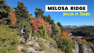
It’s a really panoramic trail with amazing sections in the forest and some view points on the way. It starts from the Rifugio Allavena and finishes just at the starting point of some other amazing trails. So you can ride it in combination with other trails.
It touches the road at half way.
Not particularly difficult, but slippery when wet; some little uphill sections.

Recent Activity on Trail

Past Week
  • 1 rides
  • 36 miles average
6 Months
  • 12 rides
  • 19 miles avg distance
All
  • 106 rides
  • Last: Jun 28, 2026
c1c2c3c4
January
February
March
April
May
June
July
August
September
October
November
December
Status:
on Sep 21, 2025
Dry
Avg: 4.24 (8 votes)
Your vote: 0

view (467)
close
3D
Trail Conditions
  • Unknown
  • Snow Groomed
  • Snow Packed
  • Snow Covered
  • Snow Cover Partial
  • Freeze/thaw Cycle
  • Icy
  • Prevalent Mud
  • Wet
  • Variable
  • Ideal
  • Dry
  • Very Dry
Trail Flow (Ridden Direction)
Trailforks scans users ridelogs to determine the most popular direction each trail is ridden. A good flowing trail network will have most trails flowing in a single direction according to their intension.
The colour categories are based on what percentage of riders are riding a trail in its intended direction.
  • > 96%
  • > 90%
  • > 80%
  • > 70%
  • > 50%
  • < 50%
  • bi-directional trail
  • no data
Trail Last Ridden
Trailforks scans ridelogs to determine the last time a trail was ridden.
  • < 2 days
  • < 1 week
  • < 2 weeks
  • < 1 month
  • < 6 months
  • > 6 months
Trail Ridden Direction
The intended direction a trail should be ridden.
  • Downhill Only
  • Downhill Primary
  • Both Directions
  • Uphill Primary
  • Uphill Only
  • One Direction
Contribute Details
Colors indicate trail is missing specified detail.
  • Description
  • Photos
  • Description & Photos
  • Videos
Trail Popularity ?
Trailforks scans ridelogs to determine which trails are ridden the most in the last 9 months. Trails are compared with nearby trails in the same city region with a possible 25 colour shades. Think of this as a heatmap, more rides = more kinetic energy = warmer colors.
  • most popular
  • popular
  • less popular
  • not popular
ATV/ORV/OHV Filter
Max Vehicle Width
inches
US Cell Coverage
Legend
cell carrier legend

Radar Time
Activity Recordings
Trailforks uses anonymized public activity data. ?
Activity Recordings
Trailforks uses anonymized public activity data. ?
Personal Heatmap
Activity Types
all / none
Options
2
Date range month
Winter Trails
Warning A routing network for winter maps does not exist. Selecting trails using the winter trails layer has been disabled.
Missing Trails
Most Popular
Least Popular
Trails are colored based on popularity. The more popular a trail is, the more red. Less popular trails trend towards green.
Jump Magnitude Heatmap
Heatmap of where riders jump on trails. Zoom in to see individual jumps, click circles to view jump details.
BC Backroad Status

Service Road Atlas is a free to use, community-driven service for viewing and creating reports on the numerous back-country service roads around B.C. and Alberta.

map legend
Slope Aspect
Direction the slope faces
Flat N NE E SE S SW W NW
Trails Deemphasized
Trails are shown in grey.
disable
Only show trails with no bike usage.
Enable
Suggested Layers
Based on selected activity type

    Save the current map location and zoom level as your default home location whenever this page is loaded.

    Save
        Directions to melosa-ridge trailhead (43.987610, 7.683280)

        Photos

        7 more »
        44 |
        Jul 30, 2025 @ 6:52am
        Jul 30, 2025
        49 |
        May 13, 2025 @ 2:51pm
        May 13, 2025
        55 |
        Sep 23, 2024 @ 10:20pm
        Sep 23, 2024
        40 |
        Sep 23, 2024 @ 10:20pm
        Sep 23, 2024

        Videos

        1 more »
        MTB Melosa Ridge (Molini di Triora)
        17:46 | 45 | Feb 13, 2026 , Molini di Triora

        1 Review & Comments


        We hope you've been enjoying Trailforks!

        Create a FREE account to view trail comments and much more.

        • By Atipico-outdoorescape & contributors
        • #444728 - 1,236 views

        Frequently Asked Questions About Melosa Ridge

        Where is Melosa Ridge located?
        Melosa Ridge is located in Molini, Molini di Triora, Italy. It is part of the Molini trail network. The trailhead is located at coordinates 43.98761, 7.68328.
        How hard is Melosa Ridge?
        Melosa Ridge is rated as Blue difficulty. The physical rating is Moderate. The average grade is 7.1%. The climb difficulty is rated Black Diamond.
        What is the elevation gain for Melosa Ridge?
        Melosa Ridge has 49 m of elevation gain. The trail has 469 m of elevation descent. The elevation ranges from 1,142 m to 1,566 m.
        Is Melosa Ridge a point to point trail?
        Melosa Ridge is not a point to point trail. The direction is Downhill Primary. The trail type is singletrack.

        Hit the Trail

        Open in App

        Get this trail on your phone instantly.
        open trail in app

        Download Trail

        Save to wishlist, Garmin & download.
        save the trail

        Find Related Routes

        Find routes and users activities that include this trail.
        find routes for this trail

        You must enter a description before submitting.