


Open in App
Get this trail on your phone instantly.

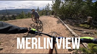
Built in 2014, Merlin View followed the successful build of Bobcat the previous year and it shares the same trademark features: consistent grades for easier climbing and flowing descents, sweeping bermed corners, rollers, bumps & table-tops. It has some good views too but you're likely to be too engaged by the trail to notice
Easily accessed from the trailhead via Braggin' Rights, Merlin View is a loop that should be ridden counter clockwise, and combines seamlessly with Braggin' Rights to create a fairly easy & shortish (14km) ride. You could also add Merlin to the traditional Northern Flow loop (15km) for some extra climbing. Choosing to ride Merlin View counter-clockwise gives you the shorter (2km, 9%) climb and the longer (3km, 6%) descent.
From the Braggin' Rights / Reconnect junction head west into the long meadow / cut-line and turn right to begin the climb (if you're riding counter-clockwise). The trail follows this cut-line for the next kilometre, snaking back and forth through the trees on either side, until it reaches a big meadow. There a bench made from boulders offers a chance for a rest at this mid-point on the climb and you can take in the views to the south & east.
The trail then enters the trees and after a short rock-armoured section it climbs to the summit before following the ridge for 500m. It dips briefly and crests another minor summit before the descent begins for real - and it continues for the next 3km!
The descent is punctuated by all sorts of berms & bumps etc. to add to the fun, but there's nothing that interrupts the flow or demands advanced riding skills.
Eventually the trail emerges into a meadow / cut-line again, and finally climbs (via one switchback in the trees) up the cut-line back to the Braggin' Rights junction. Take the right turn there to return directly to the trailhead.
| c1 | c2 | c3 | c4 |
|---|---|---|---|
January | February | March | April |
May | June | July | August |
September | October | November | December |

Service Road Atlas is a free to use, community-driven service for viewing and creating reports on the numerous back-country service roads around B.C. and Alberta.
Save the current map location and zoom level as your default home location whenever this page is loaded.
SaveWe hope you've been enjoying Trailforks!
Create a FREE account to view trail comments and much more.
You must enter a description before submitting.

