more stats
2.4 miles
Distance
41 ft
Climb
-1,280 ft
Descent
00:23:37
Avg time
-1,239 ft
Altitude change
3,229 ft
Altitude min
4,475 ft
Altitude max
4,468 ft
Altitude start
3,228 ft
Altitude end
-9.8%
Grade
-52.3%
Grade max
11.4%
Grade min
1,135 ft
Distance climb
2 miles
Distance down
499 ft
Distance flat
00:23:37
Avg time

Middle Sam Merrill Details

  • Activities
    • Mountain Bike
    • Hike
    • Trail Running
  • Riding Area
    Angeles National Forest
    Pasadena, California
  • Difficulty Rating
  • Voted Difficulty
    Double Black Diamond (2 votes)
  • Local Popularity
    70 in Mountain Biking [+]
    • 5 in Trail Running
    • 55 in Hiking
  • Global Ranking
    #37099 in Mountain Biking [+]
    • #48577 in Trail Running
    • #61618 in Hiking
  • Trail Type
    Singletrack
  • Bike Type
    AM
  • Direction
    Downhill Primary
    Popular Direction Shown
  • Physical Rating
    Hard
  • Season
    All Year
  • Dogs Allowed
    Yes
  • eBike Allowed
  • Ride in Rain
    Yes

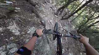
Middle Sam Merrill starts from the Mt Lowe Fire Road at the intersection to Inspiration Point. The single track trail is narrow, exposed and loose. It begins on the shady side of the mountain and wraps around to the sunny side where it gets increasingly loose and dry. This is an advanced trail with exposure, rock drops, etc.

Be aware this is a multi use trail and hikers are commonly found coming up from the Echo Mtn ruins below. Bell use is highly recommended and appreciated by other trail users. This trail commonly causes flats so be prepared with extra tubes, pump, etc. Also a good idea to check your brakes before riding this trail as you will be using them and using them heavily.

Trail Supporters

  • USFS
    Land Manager
Local Trail Association
Traditionally Indigenous Territory

Recent Activity on Trail

Past Week
  • 0 rides
  •  
6 Months
  • 6 rides
  • 17 miles avg distance
All
  • 158 rides
  • Last: Jun 6, 2026
c1c2c3c4
January
February
March
April
May
June
July
August
September
October
November
December
update trails status or condition

Middle Sam Merrill Trail Reports

statusdatedescription
May 25, 2026 @ 6:14pm (America/Los_Angeles)
May 25, 2026
Mar 19, 2026 @ 10:11pm (America/Los_Angeles)
Mar 19, 2026
There's been some work done. Brush is cleared, path is distinct and it seems the difficult features aren't as difficult as if it has been cleared...
Sep 13, 2025 @ 10:55pm (America/Los_Angeles)
Sep 13, 2025
Still closed.
Sep 7, 2025 @ 3:56pm
Sep 7, 2025
The last part leading to the ruins is fun and glory. Everything else is just awful. Constant HaB due to the trail having turned into a sandy silty...
Jan 30, 2025 @ 2:59pm
Jan 30, 2025
more »
Status:
on May 25, 2026
Dry
Avg: 4.43 (17 votes)
Your vote: 0

view (2,753)
close
3D
Trail Conditions
  • Unknown
  • Snow Groomed
  • Snow Packed
  • Snow Covered
  • Snow Cover Partial
  • Freeze/thaw Cycle
  • Icy
  • Prevalent Mud
  • Wet
  • Variable
  • Ideal
  • Dry
  • Very Dry
Trail Flow (Ridden Direction)
Trailforks scans users ridelogs to determine the most popular direction each trail is ridden. A good flowing trail network will have most trails flowing in a single direction according to their intension.
The colour categories are based on what percentage of riders are riding a trail in its intended direction.
  • > 96%
  • > 90%
  • > 80%
  • > 70%
  • > 50%
  • < 50%
  • bi-directional trail
  • no data
Trail Last Ridden
Trailforks scans ridelogs to determine the last time a trail was ridden.
  • < 2 days
  • < 1 week
  • < 2 weeks
  • < 1 month
  • < 6 months
  • > 6 months
Trail Ridden Direction
The intended direction a trail should be ridden.
  • Downhill Only
  • Downhill Primary
  • Both Directions
  • Uphill Primary
  • Uphill Only
  • One Direction
Contribute Details
Colors indicate trail is missing specified detail.
  • Description
  • Photos
  • Description & Photos
  • Videos
Trail Popularity ?
Trailforks scans ridelogs to determine which trails are ridden the most in the last 9 months. Trails are compared with nearby trails in the same city region with a possible 25 colour shades. Think of this as a heatmap, more rides = more kinetic energy = warmer colors.
  • most popular
  • popular
  • less popular
  • not popular
ATV/ORV/OHV Filter
Max Vehicle Width
inches
US Cell Coverage
Legend
cell carrier legend

Radar Time
Activity Recordings
Trailforks uses anonymized public activity data. ?
Activity Recordings
Trailforks uses anonymized public activity data. ?
Personal Heatmap
Activity Types
all / none
Options
2
Date range month
Winter Trails
Warning A routing network for winter maps does not exist. Selecting trails using the winter trails layer has been disabled.
Missing Trails
Most Popular
Least Popular
Trails are colored based on popularity. The more popular a trail is, the more red. Less popular trails trend towards green.
Jump Magnitude Heatmap
Heatmap of where riders jump on trails. Zoom in to see individual jumps, click circles to view jump details.
BC Backroad Status

Service Road Atlas is a free to use, community-driven service for viewing and creating reports on the numerous back-country service roads around B.C. and Alberta.

map legend
Slope Aspect
Direction the slope faces
Flat N NE E SE S SW W NW
Trails Deemphasized
Trails are shown in grey.
disable
Only show trails with no bike usage.
Enable
Suggested Layers
Based on selected activity type

    Save the current map location and zoom level as your default home location whenever this page is loaded.

    Save
        Directions to middle-sam-merrill trailhead (34.224180, -118.110260)

        Photos

        23 more »
        96 |
        Jul 17, 2024 @ 9:31pm
        Jul 17, 2024
        209 |
        Nov 7, 2021 @ 8:44am
        Nov 7, 2021
        316 |
        Nov 7, 2021 @ 8:44am
        Nov 7, 2021
        208 |
        Nov 7, 2021 @ 8:44am
        Nov 7, 2021

        Videos

        19 more »
        youtuber Middle Sam Merrill / Pasadena, CA / MTB
        9:43 | 202 | Jul 11, 2024 , Pasadena
        youtuber MT Wilson : Saving Rider from a Tragic Fall #bike
        11:55 | 183 | Jan 12, 2024 , Pasadena
        Don't Ride This Trail if You're Scared...
        8:00 | 138 | Jan 4, 2024 , Pasadena
        youtuber SAM MERRIL
        17:08 | 172 | Apr 11, 2023 , Pasadena

        Routes with this trail

        5.0 8 miles 691 ft 7 Shuttled
        Shuttle run from top of Mt. Lowe East to the bottom of .
        5.0 13 miles 1,514 ft 12 Shuttled
        This shuttle Route is one Variation of the so called Front side riding area in the Angeles National Forest.
        4.0 14 miles 840 ft 14
        Mt.Wilson shuttle is one of Southern California's most challenging trails, so much fun!

        1 Review & Comments


        We hope you've been enjoying Trailforks!

        Create a FREE account to view trail comments and much more.

        • By betamax-bandit & contributors
        • #20978 - 7,922 views

        Frequently Asked Questions About Middle Sam Merrill

        Where is Middle Sam Merrill located?
        Middle Sam Merrill is located in Angeles National Forest, Pasadena, California, United States. It is part of the Angeles National Forest trail network. The trailhead is located at coordinates 34.22418, -118.11026.
        How hard is Middle Sam Merrill?
        Middle Sam Merrill is rated as Black Diamond difficulty. The physical rating is Hard. The average grade is 9.8%.
        What is the elevation gain for Middle Sam Merrill?
        Middle Sam Merrill has 41 ft of elevation gain. The trail has 1,280 ft of elevation descent. The elevation ranges from 3,229 ft to 4,475 ft.
        Is Middle Sam Merrill a point to point trail?
        Middle Sam Merrill is not a point to point trail. The direction is Downhill Primary. The trail type is singletrack.

        Hit the Trail

        Open in App

        Get this trail on your phone instantly.
        open trail in app

        Download Trail

        Save to wishlist, Garmin & download.
        save the trail

        Find Related Routes

        Find routes and users activities that include this trail.
        find routes for this trail

        You must enter a description before submitting.